The commercial remote sensing boomby Jeff Foust
|
| “We were building satellites that looked and felt like PCs in a satellite world where everybody else was building mainframes,” said Skybox’s Mann. |
Skybox used that funding to develop a different approach to commercial remote sensing: rather than build a few very capable—but also very expensive—satellites, Skybox planned to develop a larger number of smaller satellites. While the images these satellites would produce would not be as sharp as those from bigger satellites, the larger number of satellites would reduce what in the industry is known as “revisit time,” the gap between images of the same location. A sufficiently large constellation could, conditions permitting, provide images of the same location every day, or even multiple times per day.
“Ultimately, the core idea behind Skybox was really, really simple,” said Julian Mann, the vice president of product management at Skybox and one of the company’s co-founders, in a presentation about the company last year at Stanford University. “We were building satellites that looked and felt like PCs in a satellite world where everybody else was building mainframes.”
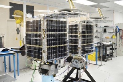
In November of last year, a Dnepr carrying Skybox’s first satellite, SkySat-1, lifted off from the Yasny Launch Base in southern Russia. Since then, Skybox has been showing off some of the images that satellite has provided, at panchromatic (black and white) resolutions of as sharp as 90 centimeters per pixel—relatively high resolution, although not as good as those from DigitalGlobe’s fleet of satellites. However, SkySat-1 can do something those other satellites can’t: take snippets of HD video up to 90 seconds long, a capability the company described as the ability “to gather dynamic information about the world around us at an unprecedented scale.”
The real strength of Skybox’s approach, though, required the company to develop a constellation of them that ultimately would be as large as 24 satellites. While SkySat-2 awaits launch later this year, the company signed contracts in February with Space Systems Loral to build 13 more satellites and with Orbital Sciences to launch six of them on a commercial version of the company’s Minotaur rocket, with options for additional launches. Those contracts, though, raised questions in the space industry: even when taking into account the lower cost of these smaller satellites, the value of these contracts likely exceeded the funds the company had raised to date. With its sole on-orbit satellite likely generating little revenue, the company needed to raise more money to build out its constellation—or find someone with deeper pockets to buy out the company.
Last week, the latter option emerged. Google announced June 10 it was acquiring Skybox Imaging for $500 million in cash, subject to various regulatory and shareholder approvals. “Skybox’s satellites will help keep Google Maps accurate with up-to-date imagery,” Google said in a brief statement announcing the deal. “Over time, we also hope that Skybox’s team and technology will be able to help improve Internet access and disaster relief—areas Google has long been interested in.”
Skybox was a little more effusive in its own announcement of the sale. “The time is right to join a company who can challenge us to think even bigger and bolder, and who can support us in accelerating our ambitious vision,” the company said in its own statement. “We both believe in making information (especially accurate geospatial information) accessible and useful.”
The deal was not particularly surprising to industry followers, who had heard rumors since at least April that Google was interested in acquiring Skybox. Some of those earlier rumors had suggested an even higher sales price for Skybox—on the order of $1 billion, by some accounts. However, Google will have to spend several hundred million dollars on top of the $500 million purchase price to build and launch that constellation, making the deal less of a bargain than it might initially seem.
| “We are imaging the planet to save the planet,” Marshall said. “Our mission is to create information people need to help life on the planet.” |
Skybox is not the only company, though, pursuing plans for constellations of remote sensing satellites. Nearly one year ago, Planet Labs unveiled its plans to develop a constellation of CubeSat-class satellites to provide medium-resolution imagery of the Earth, similar to the types provided by Landsat (see “Smallsat constellations: the killer app?”, The Space Review, July 1, 2013).
Since that announcement, Planet Labs has already deployed its first constellation, or “Flock,” of smallsats. An Orbital Sciences Cygnus cargo spacecraft ferried the 28 Flock-1 satellites to the International Space Station in January, which then deployed the satellites into orbit in the following weeks. In March, the company announced plans to launch more than 100 additional satellites over the next 12 months, using a combination of Russian and American vehicles, allowing the company to take imagery of the entire planet daily.
“We are imaging the planet to save the planet,” Planet Labs co-founder Will Marshall said in the March announcement. “Imaging the Earth at this frequency will help us to measure things from deforestation, to improving agricultural yield, to detecting overfishing. Our mission is to create information people need to help life on the planet.”
Planet Labs, which raised $52 million in a “Series B” funding round late last year, has been quiet of late about the performance of its satellites, or when the next group of them will be launched. Satellite observers have noted that about half of that original group of 28 satellites have already deorbited, not necessarily surprising given the effects of atmospheric drag on such small spacecraft that lack propulsion to raise their orbits. (The company did not respond to an inquiry late last week about the status of the Flock-1 satellites and the launch of future satellites.)
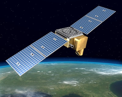 An illustration of one of 18 satellites that OmniEarth plans to launch by 2018 to provide global daily imagery for businesses and governments. (credit: Dynetics, Inc.) |
Other constellation contenders
Just last month, not one but two companies announced plans to develop their own constellations of remote sensing satellites. In early May, Russian-American aerospace company Dauria Aerospace announced a partnership with Spanish firm Elecnor Deimos to develop a constellation of remote sensing satellites. Eight Perseus-O satellites, to be built by Dauria, will join Elecnor Deimos’s existing Deimos-1 satellite (Deimos-2 is slated for launch on a Dnepr rocket later this month) by 2016.
“Deimos Perseus will allow for in-depth monitoring of wild fires, floods, crop yields, forest composition, among other agricultural and forestry data processing,” said Fabrizio Pirondini, head of the remote sensing business unit at Elecnor Deimos. “By 2016, Deimos Perseus will be able to image the entire Earth on a daily basis.”
The companies haven’t released many more details about their plans, although Dauria notes that the $20 million it raised from I2BF Global Ventures last October will be used to support development of the Perseus system, one of several smallsat concepts under development by the company.
| “It’s not a picture-taking system, although we’re going to take great pictures,” Dyrud said. “We’re not a picture-taking company, but instead a geospatial analytics company.” |
Dauria itself has an unusual organization, with offices both at the NASA Research Park, on the campus of NASA’s Ames Research Center, and in the Skolkovo Innovation Center, a high-tech research center outside Moscow. Such an arrangement would appear to be particularly problematic given the increased tensions between the US and Russia in recent months, but company president Mikhail Kokorich said in an interview in April during the Space Tech Expo in Long Beach, California, that the crisis had not yet caused any problems for the company, which is formally headquartered in Germany.
In late May, a new venture, OmniEarth, announced plans to deploy its own satellite constellation. Its planned constellation of 18 satellites, to be built by Dynetics with the support of Draper Labs and Harris Corporation, will also be able to provide medium-resolution imagery—about 2 to 5 meters per pixel, using many of the same spectral bands as Landsat—of the entire Earth, once per day.
“We are seeing a dramatic increasing need, from business leaders and society in general, to be able to assess, manage, and ultimately predict that global business activity and how it interplays with the Earth itself,” sais Lars Dyrud, president and CEO of OmniEarth, at a press conference announcing the venture during the 30th Space Symposium in Colorado Springs on May 20. “We’re at a time where advances in satellite technology and big data are presenting us with this significant opportunity to bring this capability to reality.”
Dyrud said that OmniEarth would focus less on the imagery its satellites will produce and more on the data that can be extracted from them. “It’s not a picture-taking system, although we’re going to take great pictures,” he said. “What we’re doing is trying to design an end-to-end system that maximizes the value of the data coming out of the system to be able to inform decisions. We’re not a picture-taking company, but instead a geospatial analytics company.”
OmniEarth current plans to launch its first satellite in the first quarter of 2016, with five more to follow by the end of that year; the remaining 12 would launch in 2018. The company is working to raise the estimated $250 million needed to develop and launch the system. Part of that could come from a hosted payload opportunity: the company is reserving payload space on its satellites for complementary payloads that seek to take advantage of the coverage offered by the OmniEarth system and its other characteristics, including data transmission rates of up to 1.2 gigabits per second.
Future prospects for big and small
The developments of these constellations of smallsat Earth imaging systems, one of them now backed by one of the world’s most powerful companies, might at first glance appear threatening to the incumbent provider, DigitalGlobe. It even appears to some as an example of disruptive innovation as popularized by Clayton Christensen in The Innovator’s Dilemma. However, DigitalGlobe has one key advantage over its smallsat rivals: its satellites can provide much sharper imagery.
And, last week, a change in policy helped DigitalGlobe extend that advantage. The company announced June 11 that the Commerce Department, which regulates commercial remote sensing systems in the US, will allow DigitalGlobe to sell commercially images with resolutions better than the previous limit of 50 centimeters per pixel. That change applies immediately to two of the company’s current satellites, GeoEye-1 and WorldView-2, which can take panchromatic images at resolutions of 41 and 46 centimeters, respectively.
| “The laws of physics still operate, and it takes a certain aperture size to achieve certain resolutions,” Hamel said of the value of larger remote sensing satellites. |
DigitalGlobe’s next satellite, WorldView-3, slated for launch in August, will be able to take images with resolutions as sharp as 31 centimeters per pixel. The new policy will allow the company to sell images at those resolutions starting six months after the satellite is declared operational. The GeoEye-2 satellite, substantially complete but with no firm launch date, will have similar capabilities.
The ruling is a major win for DigitalGlobe, which had been, with other members of the satellite commercial remote sensing industry, been lobbying for the change in resolution limits for several years, predating the company’s merger with the former GeoEye. Those companies had warned that without a change in resolution limits, US companies would be at a disadvantage to foreign firms, whose satellites, not limited by US regulations, have become increasingly capable.
“Our customers will immediately realize the benefits of this updated regulation, as for the first time, we will be able to make our very best imagery available to the commercial market,” DigitalGlobe CEO Jeffrey Tarr said in a statement announcing the revised policy. “As a result of this policy update and the forthcoming addition of WorldView-3 to our constellation, DigitalGlobe will further differentiate itself from foreign competition and expand our addressable market.”
So which approach will win out: the traditional large satellites, launched individually and capable of very high resolution imagery; or constellations of smaller satellites that can provide imagery more frequently? Mike Hamel, president of the Commercial Ventures division within Lockheed Martin Space Systems Company, said last week that the company was keeping an eye on the emerging smaller systems, but still believed larger satellites will play a role going forward.
“The laws of physics still operate, and it takes a certain aperture size to achieve certain resolutions,” he said in an interview during a company media day June 9 in Arlington, Virginia. He added that he thought the performance and reliability of the company’s satellites—it manufactured the IKONOS and GeoEye-2 satellites—allowed it to stand out favorably versus emerging smallsat constellations.
“We think there will probably be a mix over time, and we certainly will be keeping an eye towards what the opportunities are,” he added.
Among the smallsat constellation developers, there’s a scramble to try to differentiate from each other, with Skybox emphasizing its higher resolution and others their range of spectral bands, revisit times, and other attributes. “It means the same market, but different approaches and different segments,” Dauria’s Kokorich said in April as he described how his company’s system could coexist with Skybox and Planet Labs.
Ultimately, the success of any of these ventures will depend on what the market wants. And, for now, there’s no agreement on what exactly the market wants in terms of resolution, revisit time, cost, or other attributes. DigitalGlobe, publicly traded on the New York Stock Exchange, saw its shares drop four percent on June 10, the day the Google announced its acquisition of Skybox. (Google has been a major customer of DigitalGlobe’s imagery, and the market assumed a Skybox acquisition would end that relationship.) The next day, though, the company regained nearly all that lost value on news that the government was loosening its resolution images on the company’s commercial imagery—only to lose it again, and more, the next day.
Thus, it’s a little premature to start picking winners and losers in the market. Even Skybox, with the Google acquisition, is not assured of commercial success. Google has had a mixed record with acquisitions in general: the success of YouTube, for example, is offset by the disappearance of other companies it’s acquired, like Jaiku and Dodgeball. Some speculate that Google is less interested in Skybox’s capabilities for remote sensing satellites than for its smallsat expertise in general, which could be repurposed for the company’s rumored interest in a constellation of satellites to provide broadband global Internet access.
What it does suggest, though, is that the commercial satellite remote sensing industry is a lot more vibrant—and, for observers, bound to be a lot more interesting—than what people might have thought just a couple years ago.