Candy CORN: analyzing the CORONA concrete crosses mythby Joseph T. Page II
|
| I’ve got a filing cabinet in my basement filled with declassified NRO documents relating to CORONA (and a few other programs), and I had never heard this tale of concrete crosses in the desert within a CORONA context. |
The rest of the article hit a Cold War armchair historian’s sweet spot: parents who worked on secret programs they couldn’t talk about, what the CORONA satellite program did for US military planners and intelligence analysts, and the pride of surviving the threat of nuclear war. Admittedly, the tale was captivating: two adventurers venturing upon a “secret” that was hidden out in the open desert for decades.
However, once I heard the word “CORONA” mentioned, I knew something was amiss. As a space history researcher and frequent Freedom of Information Act (FOIA) requestor, I’ve got a filing cabinet in my basement filled with declassified National Reconnaissance Office (NRO) documents relating to CORONA (and a few other programs), and I had never heard this tale of concrete crosses in the desert within a CORONA context. [2]
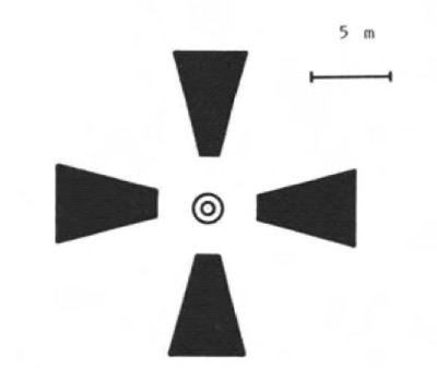 Design of a Casa Grande Aerial Target. |
What was CORONA?
CORONA was the program name for a series of photographic intelligence satellites that provided coverage of the Soviet Union, China, and other areas from its first successful flight in 1960 until its retirement in 1972. Intelligence analysts used satellite imagery for a variety of analytical purposes, ranging from monitoring Soviet strategic force development and deployment to estimating the size of grain production in Communist countries. The program’s major accomplishment early in its history was photographing all Soviet medium-range, intermediate-range, and intercontinental ballistic missile sites during the early 1960s, proving that there indeed was a “missile gap” but it was wholly in favor of the American side. [3]
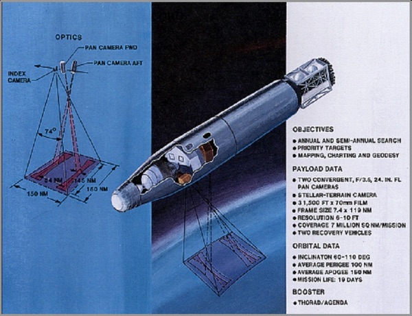 CORONA mission profile. (credit: NRO) |
Dr. Kevin Ruffner’s coverage of the program in his 1995 monograph “CORONA: America’s First Satellite Program,” gives a comparison table of CORONA cameras, as well an excellent explanation for a layperson:
“The first four versions of CORONA were designated KH-1 through KH-4 (KH denoted KEYHOLE); KH-4 went through three versions. The camera in KH-1 - public cover name DISCOVERER - had a nominal ground resolution of 40 feet. (Ground resolution is the ground size equivalent of the smallest visible imagery and its associated space). By 1963, improvements to the original CORONA had produced the KH-2 and KH-3, with cameras that achieved resolutions of 10 feet.” [4]
| Version | Camera | Launches | Time Period |
|---|---|---|---|
| KH-1 | C | 10 | 1959-60 |
| KH-2 | C’ (C Prime) | 10 | 1960-61 |
| KH-3 | C’’’ (C Triple Prime) | 6 | 1961-62 |
| KH-4 | M (Mural) | 26 | 1962-63 |
| KH-4A | Janus (J-1) | 52 | 1964-69 |
| KH-4B | Janus-3 (J-3) | 17 | 1967-72 |
Source: Ruffner, CIA 1995
The first photo provided by the CORONA system was of the Mys Shmidta airfield in August 1960 (Image 4). The image had an estimated ground resolved distance around 40 feet (12 meters) and the runway is barely discernable as a small, straight, light-colored strip, with the parking apron as a nearby light-colored rectangle. [5]
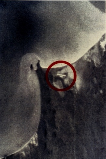 Mys Shmidta airfield, 1960. North is toward upper-left of photograph. (credit: NRO) |
Questioning the story’s ingredients
I could not come up with a satisfactory answer why the government would build a fixed optical range with such large targets specifically for CORONA in a post-1966 timeframe and not mention it in documentation anywhere. One website states the targets were calibration targets for CORONA from 1966 until 1972. The targets were supposedly abandoned due to shifting caused by subsidence from nearby ground water pumping. [6] Even Wikipedia has a page about these “Corona Satellite Calibration Targets.” Keen observers will note that while NRO references are listed at the bottom, no specific document is identified with information on either Casa Grande or the concrete cross dimensions. [7]
As someone who knows a little about CORONA, I wondered about why the programmatic specifics didn’t match up with the concrete cross myth… er… “story.” I had even more questions to mull over:
- What was the purpose of maintaining a (large) fixed size target, let alone nearly 300 of them, when camera resolution increased over the lifetime of the program? The range would be worthless after the KH-1 cameras obtained resolution better than 40 feet. [8]
- Why have a fixed range in one location that might not be under the satellite’s ground trace during a mission? Orbital shift due to Earth’s rotation, and variable timelines (e.g. battery power, amount of film left, early mission recall) could not guarantee a CORONA mission would pass over Arizona each flight or that film was available to photograph it.
- Why build larger targets during 1966 and beyond, when follow-on systems such as GAMBIT had much better resolution than the limits reached by CORONA’s best satellites (KH-4 series) at the time? The first KH-7 GAMBIT-1 was launched in 1963, and the high-resolution KH-8 GAMBIT-3 was first launched in 1966.
I received a banal response after emailing the webmaster of BornTourist.com and questioning some of the “facts” listed on their Corona Calibration Target page:
The targets at Casa Grande were not used to test camera resolution; they were used for something called “ground truthing.” The techs back on earth had to know exactly how high the satellite/camera was to determine target size. They would take a picture of the entire 16x16 mile grid and use that known size to determine the altitude of the satellite/camera and thus extrapolate target size for that particular sequence of pictures (or maybe roll(s) of film). Another aspect of the Casa Grande grid is that alternating rows had more targets in them (west and south side). This allowed the techs to determine satellite/camera orientation. In other words, determine which way is north in the pictures.
So while camera resolution was pretty impressive back then, putting a satellite/camera in space wasn't quite so exact. To confound matters, since these were very low earth orbits - to get better target resolution - the distance to earth varied not just from mission to mission, but sometimes orbit to orbit due to atmospheric drag. Apparently there was enough of a need for better distance resolution that they built a 256 square mile grid in the desert.” [9]
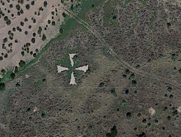
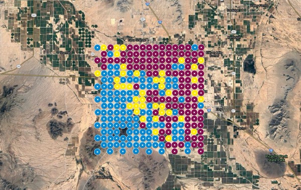 Overlay of Concrete Cross locations near Casa Grande, Arizona. Courtesy of Google Maps. |
A seemingly plausible explanation, right? The problem is that, regardless of the physics of aerial photography, there is no mention of Casa Grande within the NRO collections on CORONA. None. There was mention of an optical target range but it wasn’t fixed and was nowhere near Casa Grande, Arizona (more on that in a future article).
| I could not come up with a satisfactory answer why the government would build a fixed optical range with such large targets specifically for CORONA in a post-1966 timeframe and not mention it in documentation anywhere. |
The webmaster did indicate, however, his sourcing for the webpage: “…Local newspapers and interviews [were] the main source of information to link the Corona project to the targets.”
The bitter taste of misinformation
I re-read the NPR story online (and spin-off articles from local Arizona newspapers) and came away believing the tale was chock full of hasty generalizations and a flawed logic linking the concrete crosses to the nation’s first photographic satellite program:
- Premise: The crosses are in a methodical pattern, viewable from space.
- Premise: The brass markers date from the heyday of the Cold War (and CORONA program)
- Premise: The satellite reconnaissance program was Top Secret, so there would be no mention of a connection.
- Conclusion: The crosses were used for the CORONA program
What disturbed me the most was there was no mention of contacting the CIA or NRO or reviewing the declassified document collection on CORONA by either the adventurers or the reporters writing the story. When Executive Order 12951 declassified the CORONA satellite program on February 22, 1995, the amount of available information increased from scant mention via press releases to thousands of pages and actual imagery. [10] To handle this deluge of declassified information, the NRO instituted a public reading room at their Chantilly, Virginia, headquarters; due to a dearth of in-person visitors, a web-based portal now provides the information to the public. At the time of the story’s publication, Hajek or subsequent reporters could have used any number of released mission reports from the early CORONA missions to check their hypothesis. If specific missions were not already available, the reporter could have requested documentation using FOIA as I have done many times.
I emailed the pair of adventurers about the establishment of linkage between the crosses and CORONA:
The Corps of Engineers told us they knew nothing about the markers, but were intrigued enough to check into them. They contacted the National Geospatial Intelligence Agency (formerly the Army Mapping Service, whose name was on the markers). NGIA had to contact some retirees before they could tell the Corps anything. So that’s the chain of information. As far as any actual paper trail, we do not know. [11]
Interestingly enough, the Arizona adventurers did accidentally find a clue to the (documented) calibration network for the National Reconnaissance Program satellites: “We did find another interesting marker on the grounds of Fort Huachuca, southeast of Tucson. It looks kind of like a test pattern of vertical and horizontal bars of various lengths.”
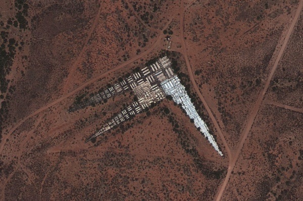 Tri-Bar Array at Fort Huachuca, Arizona. Courtesy of The Center for Land Use Interpretation. |
A fallen recipe
Believing that an optical range of this size and complexity could not stay hidden, I changed my research approach and looked in a very unlikely place: a public newspaper archive. I found what I believe to be the answer on the front page of the Casa Grande Dispatch (Pinal County Edition), dated May 31, 1967: “CG [Casa Grande] Area to be Subject of Precise Photography.” [12]
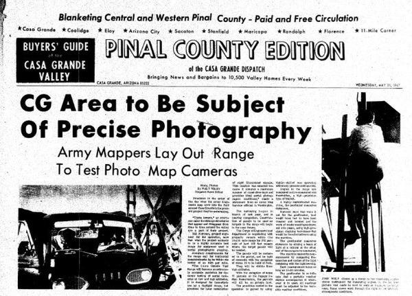 Casa Grande Dispatch, May 31, 1967. Courtesy of NewspaperArchive.com |
| The idea that the Casa Grande range was developed for the CORONA program is asinine when looking at the timelines of range construction, stories about the range’s purpose twice posted on the front page of a local newspaper, the government photogrammetry description, and the technical aspects of what the satellites required for calibration. |
Walt Wiley’s front-page story tells of a US Army Corps of Engineers effort to create “…an extremely accurate yardstick for dynamic testing of aerial cameras at low and high altitudes.” A follow-up article on October 8, 1968, provides estimated costs and timelines, and a curious statement by Roger Lewis, an aide to Arizona Representative Morris Udall: “I was told the markers would be used for photography testing for aircraft at low or extremely high altitude.” The next sentence is conjecture on the part of Lewis: “[Lewis] added that it was his impression that ‘high altitude’ aircraft would also include satellites.” Lewis’ reason or agenda behind this statement of conjecture is unknown. [13]
And to hammer home the linkage to aerial photogrammetry, I found this description from John O. Phillips the Chief of the Geodesy Division, Coast and Geodetic Survey, circa 1966:
“The resurvey on the original Phoenix, Arizona, test area was completed early in 1963 with modern electronic distance measuring equipment and triangulation methods, and the results were rigidly adjusted during the reporting period. The resurvey and the adjustment were performed to provide accuracy commensurate with currently used aerial photogrammetric equipment…[C]onsiderable progress has been made on surveys to establish another test range (Casa Grande Test Range) just south of the original Phoenix test area. The Casa Grande was designed to be a superaccurate range for use in dynamic calibration of aerial cameras. When completed, the Casa Grande test range will consist of 273 points positioned horizontally and vertically by precision survey methods. Each point will be elaborately paneled, and all points will be located according to an orderly arrangement within a 16-mile square area.” [19] (Emphasis added)
The idea of announcing a super-accurate photogrammetry range for reconnaissance satellites in a public document and newspaper front page (twice!)—easily available to the Soviets—during its construction phase is one of the worst examples of operational security ever… not to mention extremely unlikely.
Myth busted (?) but not dead
As of 1968, information concerning satellites performing photographic intelligence remained classified, but a widely suspected “open secret.” On October 1, 1978, President Jimmy Carter spoke at the Kennedy Space Center, acknowledging the US government’s use of “spy” satellites for the first time:
Photographic reconnaissance satellites have become an important stabilizing factor in world affairs in the monitoring of arms control agreements. They make an immense contribution to the security of all nations. We shall continue to develop them. [14]
The idea that the Casa Grande range was developed for the CORONA program is asinine when looking at the timelines of range construction, stories about the range’s purpose twice posted on the front page of a local newspaper, the government photogrammetry description, and the technical aspects of what the National Reconnaissance Program photographic satellites required for calibration. The use of satellites for reconnaissance and surveillance ostensibly remained close hold until the declassification of the NRO in 1992 and the release of CORONA programmatic information in 1995.
In the decades after the 1995 declassification (and prior to the NPR story), the NRO and CIA declassified numerous Photographic Evaluation Team (PET) Reports for CORONA and GAMBIT missions. [15] Inside each report is a list of mobile and fixed targets used for photographic evaluation. While a few sites are listed inside Arizona—near Fort Huachuca and Luke Air Force Base—they are comprised of the tri-bar optical test pattern used by the US government since the early 1950s, not 60-foot-wide concrete crosses. Note the date on the caption: 1966, which matches the time period of the Army Map Service bronze markers on the crosses.
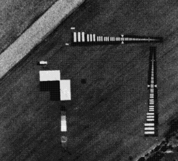 Typical Mobile Target Array in 1966. (credit: NRO) |
While the facts presented here argue against the interpolated “logic” of the CORONA/concrete cross connection, the allure of the story continues. Numerous online forums have perpetuated the story; at least one group of academicians have used the crosses as a springboard for award-winning artistic and creative analysis, and a major publication (National Geographic) included the crosses in an article about security and surveillance. [17]
With this type of viral momentum, this story likely won’t die, but will continue to be a false example of “derring-do” during the Cold War. What else perpetuates misinformation more than an air of mystery, selective information analysis, incomplete information, and a feeling of being in the know? Sounds like the perfect recipe for a CORONA conspiracy theory. [18]
References
- Hajek, Danny. “Decades-Old Mystery Put to Rest: Why are There X’s in the Desert?” National Public Radio, October 11, 2016.
- “FOIA For All.” NRO FOIA Collection.
- Oder, Fitzpatrick, Worthman. The CORONA Story (2018 release). NRO FOIA Collection.
- Ruffner, Kevin. CORONA: America’s First Satellite Program. CIA History Office, 1995.
- Index, Declassified Collection of CORONA, ARGON, and LANYARD Photographs. NRO FOIA Collection.
- BornTourist.com. Corona Calibration Targets.
- Wikipedia. Corona Satellite Calibration Targets.
- McDonald, Robert and Patrick Widlake. “Looking Closer and Looking Broader: Gambit and Hexagon – the Peak of Film-Return Space Reconnaissance After Corona.” National Reconnaissance: Journal of the Discipline and Practice, January 2012.
- Personal correspondence, October 19, 2017.
- Executive Order 12951, dated February 22, 1995
- Personal correspondence, October 17, 2017.
- Casa Grande Dispatch (Pinal County Edition), May 31, 1967. (NewspaperArchive.com)
- Casa Grande Dispatch (Pinal County Edition), October 8, 1968. (NewspaperArchive.com)
- Carter, James. Remarks at the Congressional Space Medal of Honor Awards Ceremony. October 1, 1978.
- Photographic Evaluation Report, Mission 4002 (6-8 September 1963). National Photographic Interpretation Center, March 1964.
- Air Force Special Projects Production Facility History: Volume 1 Overview. SAF/SP, 1976.
- Draper, “They Are Watching You—and Everything Else on the Planet” National Geographic, February 2018.
- Lewandowsky, Ecker, Seifert, Schwarz and Cook. “Misinformation and its Correction: Continued Influence and Successful Debiasing.” Association for Psychological Science, September 18, 2012.
- Phillips, John O. “Geodetic Operations In The United States And In Other Areas Through International Cooperation: January 1, 1963 To December 31, 1966.” Report To The International Association Of Geodesy Of The International Union Of Geodesy And Geophysics, International Council Of Scientific Unions.
Note: we are temporarily moderating all comments submitted to deal with a surge in spam.