Shipkillers: from satellite to shooter at seaby Dwayne A. Day
|
| Up until the mid-1960s, the Soviet Navy had primarily stayed relatively close to the motherland. But by the middle of that decade, Soviet vessels began traveling farther and operating longer in the world’s oceans. In August 1969, the US intelligence community, at the request of the Chief of Naval Operations, formally added a new mission for its fleet of top-secret satellites: ocean surveillance. |
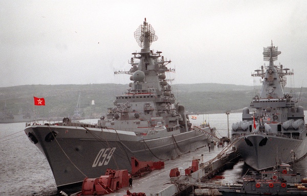
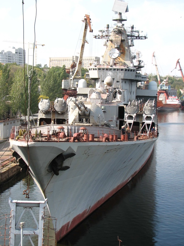
The Kirov was equipped with 20 large SS-N-19 cruise missiles. The NATO code name for this missile was “Shipwreck.” Even before the Kirov was launched, the US Navy soon began looking for ways of killing the massive cruiser before it could launch its Shipwreck missiles at American aircraft carriers. The Kirov, like most large Soviet warships, was covered in antennas. When any of them turned on, some of their emissions traveled out into space, and American satellites could intercept them.
The emergence of the Kirov was just the latest development in what US intelligence analysts had assessed as an increasingly powerful and capable Soviet Navy. Up until the mid-1960s, the Soviet Navy had primarily stayed relatively close to the motherland. But by the middle of that decade, Soviet vessels began traveling farther and operating longer in the world’s oceans. In August 1969, the US intelligence community, and the request of the Chief of Naval Operations, formally added a new mission for its fleet of top-secret satellites: ocean surveillance.[3] That mission was based upon experience gained from the POPPY 7 mission, launched in 1967 and used to track Soviet warships in the Mediterranean. POPPY was different than other American low-altitude signals intelligence satellites because it did not record the signals it intercepted but relayed them directly to a ground station—a so-called “bent pipe” system. This meant that the data relayed from the satellites was current, a vital requirement for locating moving ships. Ground stations were in the territories of American allies on the periphery of the Soviet Union, such as Turkey. Many of the POPPY ground stations were also conveniently situated near large bodies of water, meaning that when over the Soviet Union POPPY satellites could gather signals from the ground, and when over the water they could gather signals from ships, relaying them to the same ground stations.
POPPY was built by the Naval Research Laboratory (NRL) with funding provided by the National Reconnaissance Office—not Navy money. The NRL had a formal designation as “Program C” as part of the National Reconnaissance Office (the Air Force component was Program A and the CIA component was Program B.) Although the NRL conducted many research projects for the Navy, up to this point, NRL’s intelligence satellite work mostly benefitted non-Navy customers. As one official history noted, “the role of ocean surveillance late in 1970 fit in well with the interests of Navy sponsors.”[4] Now that POPPY could detect ships at sea, the Navy had a vested interest in the NRL’s signals intelligence work.
POPPY 8 was launched soon after the ocean surveillance mission was officially adopted (see “Spybirds: POPPY 8 and the dawn of satellite ocean surveillance,” The Space Review, May 10, 2021.) That mission continued and expanded the ocean surveillance mission, although details remain classified. The final POPPY mission, POPPY 9, was launched in 1971 and operated until September 1977, significantly longer than its predecessors. Although the details of these operations mostly remain classified, ocean surveillance obviously challenged the developers of new signals intelligence satellites because the ships were not stationary targets and they could be emitting their signals far from a satellite ground station.
 Artist depiction of the STRAWMAN signals intelligence satellite and a small P-11 electronic intelligence satellite. In the early 1970s, the National Reconnaissance Office used several satellites like these to search for U.S. Navy and Soviet Navy warships on the open ocean. (credit: Giuseppe De Chiara) |
Although POPPY was suited to this mission, and a follow-on system was under development by the early 1970s, American intelligence officials also sought to determine if other currently operating signals intelligence satellites could also be used for ocean surveillance.
In spring 1971, the National Reconnaissance Office conducted an operation with the US Navy called Project TANGIBLE. This involved a major naval exercise off the coast of San Diego that would be overflown by the STRAWMAN 3 and TRIPOS/SOUSEA satellites.[5] STRAWMAN 3 was a large satellite launched in August 1970 with the primary mission of identifying and locating air defense radars inside the Soviet Union. TRIPOS/SOUSEA was a much smaller satellite, generally referred to as a P-11 type, with a different set of signal detectors and a much shorter lifetime. TRIPOS/SOUSEA had been launched in May 1970 and had already exceeded its design lifetime. STRAWMAN 3 was nearing the end of its one-year design lifetime. Both satellites normally used tape recorders to record and play back the signals they intercepted. But they also had the ability to relay them directly to the ground, which improved reporting time. The NRO was apparently using them to demonstrate the ability of satellites to detect a wide array of emitters at sea.
Project TANGIBLE was not very successful, according to a top-secret memo by Colonel David Bradburn. At the time, Bradburn was director of the NRO staff, which supported the NRO director and kept him apprised of what was happening with the NRO’s various intelligence satellite programs and operations. He would later be promoted to brigadier general and run the NRO’s West Coast office, known both as Program A and by the unclassified designation Secretary of the Air Force Office of Special Projects, usually abbreviated as SAFSP or simply “Special Projects.” Bradburn reported that the initial evaluation of TANGIBLE “showed that satellite ELINT intercepts could be reported to the Navy Fleet Ocean Surveillance Information Facility (FOSIF) with an average time from observation to report of two hours and five minutes.”[6] FOSIF was located on Treasure Island in the San Francisco Bay.
| What these early 1970s operations demonstrate is that the NRO was keenly interested in adapting its signals intelligence satellites—so-called “national level” assets—to serve the Navy’s tactical needs for tracking Soviet ships at sea. |
The plan had been to compare the satellite interceptions to the actual locations of ships. They had plots of 20 out of 40 ships participating in the exercise off San Diego, and 122 of 158 reports by Navy emitters were correlated with ship locations. Individual ships were not successfully tracked from day to day, probably because they only had about two satellite observations per day over the ten-day period of the exercise. “There were more ships in the area than were reported by the satellites,” Bradburn wrote, “however, the Navy did not maintain detailed ship’s logs of radar operating time, so there is no way to be sure whether we saw all the radars that were on the air,” he added.[7] “Similarly, we cannot account for emitters reported by the satellites but uncorrelated with the ship locations furnished by the Navy, These ‘extra’ reports may be real ships in the maneuvers which were not plotted by the Navy.” Because the data was so muddled, by early September the NRO was considering halting any further attempts to evaluate the collected TANGIBLE data.[8]
TANGIBLE was soon followed by Project TACTFUL. Rear Admiral Fred Harlfinger, director of the Office of Naval Intelligence, suggested that STRAWMAN and TRIPOS/SOUSEA could also be used to monitor Soviet naval vessels. The plan was to use STRAWMAN, TRIPOS/SOUSEA, and POPPY 8 from April 23 to August 31, 1971, during an expected Soviet naval exercise. The purpose of the NRO operation was to provide processed data to the Navy “as expeditiously as possible.” The NRO quickly began working on how to communicate the information to the Navy.[9]
By this time, the NRO and Navy were already planning for the next exercise known as Operation ROPEVAL, scheduled to begin in the second week of September and last for two weeks. The maneuver area for ROPEVAL was much bigger than the earlier TANGIBLE exercise, extending all the way from Midway Island west of Hawaii to the US West Coast. TRIPOS/SOUSEA was going to be covering the area, but the NRO would not yet have the URSALA satellite in orbit. URSALA was another P-11 type satellite and was scheduled for launch in spring 1972. It would have both a wide swath detection width and rapid reporting for the entire area. URSALA’s launch was eventually delayed until July 1972.[10]
STRAWMAN 4, which had been launched in July 1971 would also participate, but it had a 200-mile (370-kilometer) detection swath that would not provide comprehensive coverage. The NRO could double the STRAWMAN coverage by calling up STRAWMAN 3 “from caretaker status for the duration of Operation ROPEVAL at a budgetary increase of $27,000 per month,” Bradburn explained. Because they only needed a month’s operation to cover the two-week exercise, that seemed like “a small price to pay to show we are interested and doing our best in a good cause,” Bradburn wrote.[11]
POPPY would have coverage of the northern part of the fleet’s maneuver area because of the location of a ground station, likely located in Hawaii. But for unexplained reasons, POPPY had not seen the maneuver area at all during TANGIBLE.[12]
The post-mission evaluations would emphasize timeliness of reporting as a prime performance measure. “Our main attention must be on POPPY, which will be in the inventory for some time rather than on TRIPOS/SOUSEA and STRAWMAN, which will not,” Bradburn explained. The Navy’s First Fleet was planning on maintaining a much better database on ship locations and radar operations than the earlier TANGIBLE operation, but Bradburn was not confident that the evaluation of satellite data would be very conclusive.[13]
By October 1971, NRO Director John McLucas recommended to NSA Director Vice Admiral Noel Gaylor that they sponsor direct reporting of STRAWMAN and P-11 satellite data to the Navy, using the same distribution concept they were then using for POPPY. “I believe that an arrangement like this would lead to faster reporting and would go a long way toward demonstrating the responsiveness of the NRO/NSA team to the needs of tactical users,” McLucas wrote.[14]
At the time, POPPY data went directly from the field intercept sites to Navy units and simultaneously to NSA Headquarters at Fort Meade for further processing, but STRAWMAN and P-11 data went from the field sites to NSA first, which then did further distribution. Because POPPY was a Navy system, it was the Navy reporting to the Navy, but for the other systems there was an NSA Support Detachment at the field site and that detachment reported to NSA Headquarters. McLucas was proposing that an NSA field unit would send its reports to the Navy units. “I would like to see the NRO and the NSA jointly displaying a very great willingness to adapt and improvise; I think we need to give solid evidence along those lines and this simple reporting system would be a most effective first step.”[15]
According to an official history, in “September 1972 a further improvement in intercept capability occurred when the new POPPY Automated Processing System (PAPS) was added to” a ground station. This resulted in a higher processing volume, processing in “a continuous stream.” Two months later two Soviet warships were located and quickly reported to the Navy.[16]
In December 1972, the US Intelligence Board gave the NRO and NSA “Special Mission Guidance” recommending that POPPY, STRAWMAN 4, and URSALA 1 “provide coverage of Soviet shipborne emitters in the Sea of Japan area for time-critical reporting during the period 7 December through 30 January 1973.” They were requesting reporting within six hours after the initial intercept. The data was supposed to go to the Commander in Chief of the Pacific Fleet and the Commander of Naval Forces, Japan.[17]
What these early 1970s operations demonstrate is that the NRO was keenly interested in adapting its signals intelligence satellites—so-called “national level” assets—to serve the Navy’s tactical needs for tracking Soviet ships at sea. Using satellites for ocean surveillance was an idea that predated those operations by at least a decade, albeit in much different form.
 After the POPPY satellites were successfully used to detect ships at sea starting in the late 1960s, by the mid-1970s the National Reconnaissance Office began launching a new series of satellites known as PARCAE. PARCAE had the primary mission of detecting the radar and communications emissions of ships. (credit: Peter Hunter Collection) |
Space-based radar
Signals emitted by Soviet warships offered one method of detecting and tracking them, but the US Navy had long been interested in the possibility of using radar from orbit to detect ships. In 1960, the Bureau of Naval Weapons’ Astronautics Program Office proposed using space-based radar to detect ships as part of project Albatross. The work was conducted by the Naval Missile Center at Point Mugu, California. Albatross would have involved six satellites in 300-nautical-mile (557-kilometer) orbits. Each satellite would have two radars looking down to either side of the ground track and use synthetic aperture techniques that layer successive radar returns on top of each other. However, Albatross was soon canceled.[18]
In late 1964, the NRO flew the QUILL radar satellite that used a synthetic aperture radar adapted from an aircraft radar to detect ground targets. Despite QUILL’s success, no follow-on program was approved, although the NRO continued to study space radar for imaging ground targets throughout the 1960s.
| The committee noted that the inability to identify ships was a major weakness; there was no way to tell a Soviet warship from an oil tanker. The radar was essentially a “blob detector.” |
In 1965, the G.W. Preston Company proposed a lightweight, low-powered radar mounted on a satellite for ocean surveillance. The Naval Research Laboratory studied the proposal and determined that it could be used for radar surveillance. Eventually, Albert Hall, the Assistant Secretary of Defense for Intelligence, initiated Program 749 to evaluate a space-based ocean surveillance radar system. Program 749 was managed by the Navy. The design would involve a conventional radar operating at L-band and scanning to the side as the satellite moved along its ground track. The Navy determined that such a system could detect and locate ships, but it would not be able to identify them.[19]
In 1969, a committee within the Office of the Secretary of Defense evaluated Program 749 and recommended that it not be transitioned to concept development. The committee noted that the inability to identify ships was a major weakness; there was no way to tell a Soviet warship from an oil tanker. The radar was essentially a “blob detector.” What the committee did not acknowledge was that radar satellites could operate with signals detection satellites that could identify the targets, the approach that the Soviet Union took in the 1970s when it began operating its own ocean surveillance system using nuclear-powered radar ocean surveillance satellites (RORSATs). The committee’s report was followed by a Department of Defense Decision Paper that concluded that although space-based radar for ocean surveillance was desirable, the inability to identify ships was too important to overlook. According to an official history of naval space activities, this view prevailed for decades.
Despite the cancellation of Program 749, the US Navy remained interested in space-based radar for ocean surveillance. In the early 1970s, the Navy began evaluating the Satellite Ocean Surveillance System (SOSS). The SOSS study concluded that a 60-foot (18.2-meter) diameter circular parabolic radar antenna mounted on a low Earth orbiting satellite could have utility for ocean surveillance. The SOSS study proposed a constellation of low Earth orbit satellites in four planes. The radar would sweep along the satellite ground track, looking fore and aft. The satellites would be nuclear hardened and jam-resistant, and would send their data through Navy FLTSATCOM satellites in geosynchronous orbit to the Navy Command and Control System.
With funding from the office of the Assistant Secretary of Defense for Intelligence, the Navy commissioned detailed studies of the SOSS concept from numerous organizations including Navy laboratories and industry teams. The minimum cost for a SOSS capability was $3.5 billion over five years. This cost was too high for Navy officials and by the mid-1970s the project was canceled.
After SOSS was canceled, the Navy turned its attention to using a space-radar system to monitor naval “choke points.” This concept, designated XOS-19, aimed to dramatically reduce costs compared to SOSS, and apparently focused on development of an initial prototype to demonstrate feasibility. Instead of SOSS’s scanning radar, the XOS-19 radar would operate in staring mode and use less expensive ground processing. The XOS-19 demonstration satellite was estimated to cost $300 million. This was still too expensive for Navy officials and XOS-19 was canceled.
By the latter 1970s, the Navy once again considered a space-based radar system. This time the goal was to use a space-based radar to differentiate between ships in a specific area, apparently to differentiate targets for Tomahawk anti-ship missiles fired at over-the-horizon targets. The system was designated Clipper Bow and concept definition started in 1977. But Clipper Bow, like previous Navy space-radar efforts, was canceled in 1979 because its $600 million price tag was too high for a system that would only provide targeting support, rather than broader ocean surveillance capabilities. After nearly two decades of study, the Navy was still unwilling to commit to a space-based radar for ocean surveillance. However, by this time, the Navy had successfully fielded an extensive satellite ocean surveillance capability that passively detected signals in orbit rather than actively emitting them.
 The PARCAE satellites were launched in groups of threes. The first satellites were built by the Naval Research Laboratory. The name derives from Roman mythology, where the Parcae determined the fate of mortals. The NRL satellites could determine the fate of ships during wartime. |
From POPPY to PARCAE
Although details mostly remain classified, an official history of American signals intelligence satellites indicates that ocean surveillance had become a major mission for the National Reconnaissance Office only a few years after it had been an approved intelligence collection goal. “By 1975 the National Reconnaissance Office SIGINT satellite world consisted of an effective set of complementary space vehicles. The low-orbiting POPPYs were busy searching for new signals and using their elegant relay techniques to provide the Navy especially, with up-to-date locations of radar-equipped ships anywhere on the surface of the Earth. Going through a constant evolution from launch to launch, POPPY proved to be the best system for intercepting ship-based radars. which were sometimes only on for a few fleeting moments as the commanders used special tactics to avoid detection. This same main-beam intercept capability was immensely powerful in determining the power and scan properties of any ground-based radar that happened to illuminate the POPPY satellites. As a main-beam collector POPPY was the best.”[20]
The last POPPY launch took place in 1971. Whereas POPPY 7’s satellites apparently lasted in orbit for two years (their exact expiration dates remain classified), the POPPY 9 satellites lasted much longer. The program was finally terminated on September 30, 1977. By this time, POPPY had been replaced by a new system also developed by the Naval Research Laboratory, which also had the classified designation of Program C of the National Reconnaissance Office.
| PARCAE had a hidden meaning as well. It was a truly clever name for a trio of satellites intended to cut short the lives of Soviet warships. |
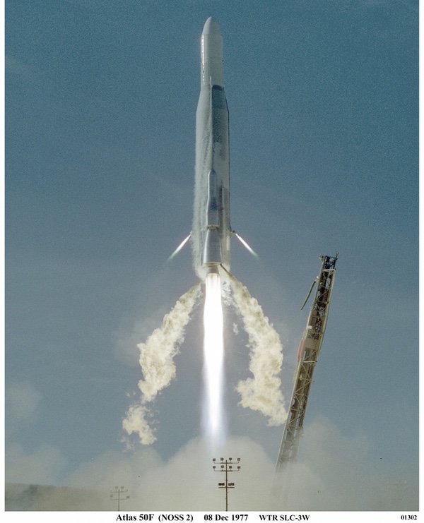
On April 30, 1976, an Atlas F rocket lifted off from Vandenberg Air Force Base carrying a new type of satellite into orbit, partly as the result of the efforts off the NRL’s Frederick Raymond and Lee Hammarstrom as well as Ronald Potts from the Naval Security Group. The BYEMAN codename for the project which had produced the spacecraft was PARCAE. Much of the work had been done during Robert Geiger’s tenure as Program C director, and it was no coincidence that the unclassified designation for the spacecraft was WHITE CLOUD—Geiger had been born in White Cloud, Kansas. There was also a dedicated network of ground stations which controlled and received data from the spacecraft as they orbited the Earth. Just as the combination of POPPY and its ground stations had an unclassified name (SISS ZULU) so PARCAE and its ground stations had their own unclassified designation: CLASSIC WIZARD.[21]
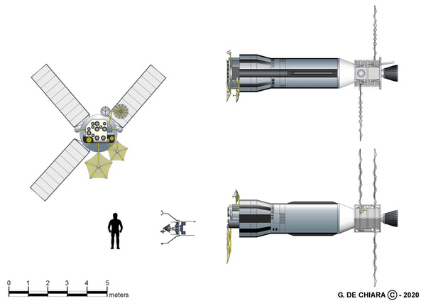
Each PARCAE mission consisted of three satellites. The Atlas placed them into a near-circular 63-degree inclined orbit at an altitude of approximately 700 miles (1,125 kilometers). PARCAE utilized a “multi-satellite dispenser” developed by Peter Wilhem and Frederick W. Raymond. The dispenser was launched atop an Atlas F rocket and would deploy the three satellites. Each satellite had six sides in a semi-pyramidal shape and a gravity-gradient stabilization boom sticking out one side to orient the spacecraft in one direction. The three subsatellites were dispersed from the main vehicle into three parallel orbits, with a displacement of approximately 1,866 miles (3,000 kilometers) between passes.[22]
The satellites employed passive interferometry techniques—the use of interference phenomena to make precise measurements—to determine the location of Soviet vessels, computing a ship’s position from data provided by several antennas that measure the direction from which a vessel’s radar or radio signals arrive.
 The PARCAE satellites were deployed from a Multi-Satellite Dispenser on top of an Atlas launch vehicle. (credit: USAF) |
The operation and purpose of the space segment was consistent with the system’s codename, for just as WHITE CLOUD had not been a random unclassified designation, PARCAE had a hidden meaning as well. The Parcae, in Greek mythology, were three sisters, daughters of Zeus and Themida. One daughter spins the thread of fate for each mortal, while the second measures out the length of thread for each. Atropos (“the one who may not flee”) cuts the measured thread of life. Thus, the first satellite detected emissions from a wide swath of the ocean, a second further narrowed down the area from which the signal originated, and a third provided the precise coordinates needed for targeting information. It was a truly clever name for a trio of satellites intended to cut short the lives of Soviet warships.[23]
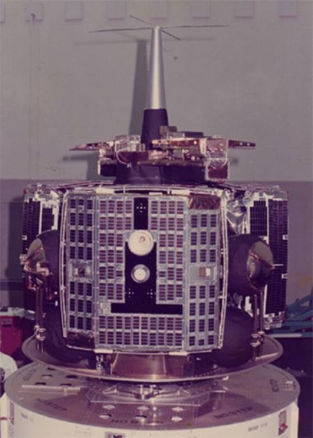
Whereas the existence of both GRAB and POPPY remained classified for nearly four decades, PARCAE’s existence leaked to the press years before it was even launched. In August 1971, Aviation Week & Space Technology reported that the US Navy was planning an ocean surveillance satellite. On May 10, 1976, the magazine reported that a late April launch of an Atlas F rocket from Vandenberg Air Force Base carried the “Navy’s first experimental ocean surveillance satellite,” built by the Naval Research Laboratory under the code name WHITE CLOUD. A follow-up article in June indicated that a main satellite had deployed three small sub-satellites into orbit, dispensing them into near-circular 700-mile (1,125-kilometer) orbits. The magazine also reported that each of the sub-satellites was “believed to carry an infrared/millimeter-wave sensor.”
A second set of ocean surveillance satellites was launched on an Atlas F in December 1977 into a similar orbit. By July 1978, Aviation Week reported that there were three satellites in each constellation, dispensed by a carrier vehicle. Each of the satellites was separated from the others by approximately 27 miles (43 kilometers) and could detect signals from a ship’s radar up to 2,000 miles (3,200 kilometers) away. According to the magazine, whereas the first two sets of satellites had been manufactured by NRL, production of the satellites had been turned over to Martin Marietta “under direction of USAF’s Space and Missile Systems Organization, with technical assistance provided by the Naval Research Laboratory.”
The magazine scored another coup on May 24, 1976, when the editors published a line drawing of the satellite. That line drawing is consistent with a series of declassified drawings dating from 1973 and depicting the Multiple Satellite Dispenser and outlines of the sub-satellites.
More PARCAE launches followed, in March 1980, February and June 1983, February 1984, February 1986, and May 1987. A December 1980 launch of an Atlas F with three of the satellites ended in failure. Amateur satellite observers determined that a complete system consisted of three equidistantly spaced orbital planes, each containing a trio of PARCAE satellites.
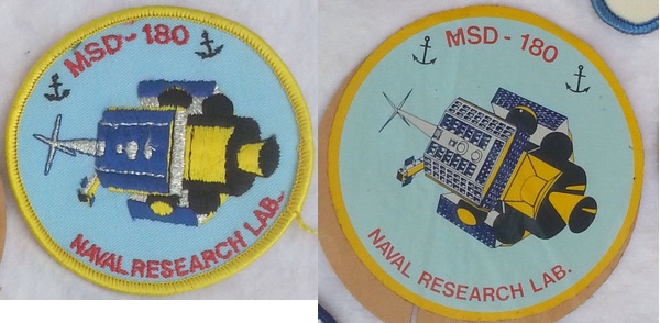 The PARCAE satellites were originally built by the Naval Research Laboratory. Somewhat unusually, they appear to have had a lower classification level than other signals intelligence satellites, and patches, photographs, and drawings of the satellites have leaked over the years, most notably in the mid-1970s when the trade publication Aviation Week & Space Technology published a series of articles about the new satellites. (credit: JB) |
Operational naval intelligence
The ground stations for PARCAE were all operated by the Naval Security Group Command, which had also operated the POPPY ground stations. They were located both in the United States and overseas. Domestic sites had been established in Adak, Alaska, and Winter Harbor, Maine. In the Pacific, a Guam station was also part of the CLASSIC WIZARD network. Two further stations had been established with the cooperation of the United Kingdom, one in Edzell, Scotland, and the other on Diego Garcia, British Indian Ocean Territory. Data received at the stations could then be quickly transmitted to regional ocean surveillance centers and then, via satellite, to a main downlink at Blossom Point, Maryland.[24]
| It is one thing to know where a Soviet ship or task force was going, but it was even more useful to understand why they were doing that, which could also help predict what they would do in the future. |
According to several accounts of American naval intelligence, the US Navy’s ocean surveillance capabilities improved substantially during the 1970s, although the satellite component remains largely classified. Desmond Ball and Richard Tanger, in their 2015 essay “The Tools of Owatatsumi: Japan’s Ocean Surveillance and Coastal Defence Capabilities,” noted that a major US Navy satellite ground station was built in Japan in the early 1970s, speculating that it was connected to the new Navy Ocean Surveillance System, or NOSS. A ground station in Japan meant that American satellites flying over the western Pacific could monitor Soviet ship movements, including when they were first leaving Soviet ports like Vladivostok.
An even more intriguing perspective was provided by Christopher A. Ford and David A. Rosenberg in 2005. Their paper, “The Naval Intelligence Underpinnings of Reagan’s Maritime Strategy” in The Journal of Strategic Studies, explained that by the 1970s, the US Navy was combining operational intelligence data from multiple sources, including the underwater SOSUS listening arrays, as well as land-based radio direction-finding systems that could detect ships at sea. Using these and other sources, the US Navy was very effectively tracking Soviet naval vessels on the oceans. Ford and Rosenberg did not explicitly mention the use of American satellites for ocean surveillance in their article (although that mission was acknowledged for many years prior to publication of their article) but imply that substantial real-time data was reaching Navy data fusion centers from satellite sources.
However, their most interesting comments are about the value of highly-placed human sources—i.e. spies—inside the Soviet government and probably the Soviet Navy, that provided much valuable context for what the Soviets were doing at sea. Thus, American naval leaders, as well as officials within the Reagan Administration, were able to understand what Soviet ships and submarines were doing when they deployed from their ports. Ford and Rosenberg were primarily interested in how this affected American naval decision-making during the Reagan Administration, but they made the insightful point that it is one thing to know where a Soviet ship or task force was going, but it was even more useful to understand why they were doing that, which could also help predict what they would do in the future.
Sensor-to-shooter via Outlaw Shark
The PARCAE spacecraft launched in the latter half of the 1970s and into the 1980s would help monitor the extensive Soviet naval presence outside home waters. By 1983, Soviet deployments reached a record high of almost 60,000 ship-days, which was five percent higher than the previous peak.[25] But in addition to greater time at sea, the Soviets were also operating newer and more capable warships, like the nuclear-powered Kirov and a class of small aircraft carriers equipped with anti-ship missiles.
A 1981 CIA report stated that between 1960 and 1970, the Soviet Union began construction of eight different classes of major surface combatants. By late 1980, 17 ships of eight different classes of major surface combatants were either under construction or fitting out at Soviet naval shipyards. These included guided missile frigates, guided missile vertical/short take-off and landing aircraft carriers, nuclear-powered cruisers like the Kirov, guided missile cruisers like the Slava class, destroyers, and a new type of frigate. The Soviet Union was increasing its numbers of surface combatants and submarines and operating them farther from the motherland.[26]
Whereas the early years of the PARCAE satellites appear to have been intended to give the US Navy the ability to track Soviet warships on the open ocean, by the 1980s, the goal became to use the satellites to enable the Navy to directly target ships with weapons. In the 2010 book From the Sea to the Stars: A Chronicle of the U.S. Navy's Space and Space-related Activities, 1944-2009, the authors describe how the US Navy in the early 1980s sought to integrate satellites directly into their warfighting. According to the book, the Naval Ocean Surveillance Information Center (NOSIC), located at Suitland, Maryland, gathered and correlated intelligence information from all sources that would be useful to the fleet. Shore-based Fleet Ocean Surveillance Information Centers or Facilities—like the one on Treasure Island used for Project TANGIBLE in 1971—were in each theater where naval forces operated. Information collected at these locations was then transmitted as classified messages to submarines, surface ships, and aircraft.
By 1983, the US Navy was facing a dilemma because its Harpoon and Tomahawk anti-ship missiles could reach beyond the sensor range of their launching ships. At the time, the PARCAE satellites were providing data to Regional Reporting Centers, which then sent it to ships at sea as messages known as SELORs, for Ships Emitter Locating Reports.
Although the details remain classified, the Navy soon adopted a new approach called the “sensor-to-shooter” concept. Instead of the PARCAE satellite data being sent to the RRCs and then to the ships, the information would be made automatically available to the weapons control stations in ships, subs, and aircraft. Navy ships and aircraft were already exchanging tactical data in near realtime. This approach meant that more data could be delivered in useable form. The data would also go to the intelligence nodes on land to be combined with other intelligence data.
This new concept required that the satellite systems collect, process, and automatically report the information. The initial plan was that space-based radar would be an additional component, but this was never developed.
This new approach required direct communications from the satellites to the ships and aircraft. This was implemented as the Tactical Data Information Exchange System-Broadcast (TADIXS-B). It was later replaced by the Tactical Receive Equipment (TRE) and Related Applications (TRAP) Broadcast. Eventually this evolved into the Integrated Broadcast Service Simplex (IBS-S). At some point the Navy developed the requirement for no more than a two-minute delay from time of observation to reporting to tactical users for early warning and targeting support—compared to the several hours it took to report the information a decade earlier. It is unclear how they achieved this impressive feat, but it apparently became the norm for the ocean surveillance system.
The equipment on board ships and submarines was modified to receive the contact reports and automatically distribute them to the weapons control stations. The Tactical Receive Equipment were developed for this purpose. In addition, the systems also needed the ability to correlate the contact reports from the satellites with other sensor data. Initially, prototype terminals known as Outlaw Shark were developed, but eventually this capability was incorporated into standard shipboard equipment upgrades. The Prototype Ocean Surveillance Terminal (POST) was also a stand-alone display system.[27]
| One Slava-class cruiser, Ukrayina, was launched in 1990 in Ukraine and sat unfinished at dockside, where it continues to rust away to this day. Naval deployments of Russian ships and submarines decreased to the point where they were almost nonexistent. The US Navy had nothing to track. |
As From the Sea to the Stars noted, this was more than just new equipment, it also required “revolutionary changes in the cultural traditions of professional communities. The fleet warfighters would have to learn to work with the satellite-generated contact reports—on occasions and under conditions selectable by individual users—as ‘tactical data’ rather than as ‘intelligence’ reports. Conversely, the national and naval intelligence communities would have to accept that, in many cases, timeliness of reporting can be more critical to tactical operators, so as to be actionable, than information value added by evaluation prior to reporting. Moreover, the intelligence communities would have to recognize that Navy operators routinely evaluate tactical-data reports received, correlating these reports with information from organic sensor systems and other sources locally available.”
 The fourth, unfinished Slava-class cruiser remained in Ukraine after the collapse of the Soviet Union. It remains there to this day. The end of the Cold War resulted in a greatly-diminished threat to the US Navy, as many Russian ships and submarines stopped going to sea. (credit: Reddit) |
The threat changes… and then goes away
The last PARCAE launch was in 1987, and the system was supplanted and then replaced in the 1990s by a new system that also involved three satellites, but was launched aboard a much more powerful Titan IV rocket. By this time, the Soviet Union had dissolved and the Cold War ended. The former Soviet Navy fell into disarray: some ships such as the powerful Kirov and Slava cruisers were stuck at pierside for much of the 1990s. One Slava-class cruiser, Ukrayina, was launched in 1990 in Ukraine and sat unfinished at dockside, where it continues to rust away to this day. Naval deployments of Russian ships and submarines decreased to the point where they were almost nonexistent. The US Navy had nothing to track. The underwater SOSUS listening arrays were decommissioned. The satellites, however, continued to fly.
Changes in the satellites probably coincided with a new Improved Ocean Surveillance System, which From the Sea to the Stars described as “the first U.S. satellite surveillance system specifically designed for the tactical requirements of Navy and other users.” The IOSS provided “surveillance and processing of contacts everywhere in the world, reported automatically to all U.S. users, routinely, without the need to be specifically tasked (compared to the ‘intelligence’ and ‘reconnaissance’ systems that are focused on geographic areas based on detailed requests and tasking for collection and reporting).” It also included “all friendly, neutral, unknown, and potentially hostile contacts (compared to only the ‘hostile and potentially hostile’ targets that comprise the defined charter of the Intelligence Community).” The reason was that ship commanders needed to know the presence and movements of all ships in an operating area to differentiate between hostiles, neutrals, and friendlies.
In addition, the data had to be updated frequently, and it also had to be provided at a classification level that could be processed by the Navy and its tactical-data systems, since not everybody who used the data would have a top-secret clearance or a need to know that the data was coming from satellites. Finally, the data had to be presented in a format so that each tactical user could manipulate it based upon their own needs and local conditions.
In late June 2021, Russia launched a unique new ocean surveillance satellite named Pion, which had been in development since the early 1990s (see “The status of Russia’s signals intelligence satellites”, The Space Review, April 5, 2021). Pion combines both passive and active systems for detecting ships at sea, collecting signals emitted by shipborne radars and communications systems, and operating a radar that can scan for ships that are trying to limit their emissions. It is unknown if the United States has developed a similar combined system. Perhaps the US Navy and the NRO have determined it is unnecessary, and detecting ship emissions is good enough. What is known, however, is that for over half a century the United States has fielded increasingly capable systems for surveilling the oceans, bringing the data they collect directly down to the captains of the ships that most need it, and into the electronic brains of the missiles they fire.
Endnotes
- “PROBABLE COMBATANT UNDER CONSTRUCTION LENINGRAD SHIPYARD BALTIC ORDZHONIKID 189, USSR,” March 22, 1981, CIA-RDP89-00121 R000200500004-2
- “STATUS OF SOVIET CONSTRUCTION PROGRAMS FOR MAJOR SURFACE COMBATANTS, DECEMBER 1980,” February 1, 1981, CIA-RDP81T00380R000100500001-7
- This mission was added to the SIGINT Overhead Reconnaissance Subcommittee’s (SORS) purview. SORS was part of the SIGINT Committee of the United States Intelligence Board, which selected targets for satellite intelligence systems. National Reconnaissance Office, “The SIGINT Satellite Story,” 1994, p. 66.
- “The SIGINT Satellite Story,” p. 259.
- Colonel David D. Bradburn, Director, NRO Staff, Memorandum for Dr. McLucas, “Subject: Project TACTFUL,” April 28, 1971, SC-2017-00007uuu.pdf
- Colonel David D. Bradburn, Director, NRO Staff, Memorandum for Dr. McLucas, “Subject: Evaluation of Project TANGIBLE and Plans for Project ROPEVAL,” September 1, 1971, SC-2017-00007xxx.pdf
- Ibid.
- Ibid.
- Colonel David D. Bradburn, Director, NRO Staff, Memorandum for Dr. McLucas, “Subject: Project TACTFUL,” April 28, 1971.
- Colonel David D. Bradburn, Director, NRO Staff, Memorandum for Dr. McLucas, “Subject: Evaluation of Project TANGIBLE and Plans for Project ROPEVAL,” September 1, 1971.
- Ibid.
- Ibid.
- Ibid.
- John L. McLucas, Director, National Reconnaissance Office, to Vice Admiral Noel Gaylor, Director, National Security Agency, October 18, 1971, SC-2017-00007yyy.pdf
- Ibid.
- “The SIGINT Satellite Story,” p. 79.
- [deleted], Executive Secretary, United States Intelligence Board, Memorandum for: Director, National Reconnaissance Office, and Director, National Security Agency, “Special Mission Guidance for POPPY – Mission [deleted], STRAWMAN 4 – Missions 7167/7236/7240 and URSALA 1 – Mission 7338,” December 5, 1972, SC-2017-00007ccc.pdf
- The Applied Research Laboratory and The Pennsylvania State University, From the Sea to the Stars, 2010, p. 485.
- Ibid.
- “The SIGINT Satellite Story,” p. 255.
- “Navy Ocean Surveillance Satellite Depicted,” Aviation Week and Space Technology, May 24, 1976, p. 22; “Expanded Ocean Surveillance Effort Set,” Aviation Week and Space Technology, June 10, 1978, pp. 22-23; Mark Hewlish, “Satellites Show Their Warlike Face,” New Scientist, October 1, 1981, pp. 36-40.
- Dwayne A. Day, “Above the clouds: the White Cloud Ocean surveillance satellites,” The Space Review, April 13, 2009; D.G. King-Hele, J.A. Pilkington, H. Hiller and D.M.C. Walker, The R.A.E. Table of Earth Satellites, 1957-1980 (New York: Facts on File, 1981), p. 444.
- A. Andronov, “Kosmicheskaya Sistema Radiotekhnicheskoy Razvedki VMS SshA ‘Uayt Klaud’ [The U.S. Navy’s ‘White Cloud Spaceborne ELINT System] Zarubezhnoye Voyennoye Obozreniye 7, 1993, pp. 57-60 (translation by Allen Thomson).
- Paul Stares, Space and National Security (Washington, D.C.: Brookings Institution, 1987), p. 188.
- Central Intelligence Agency, Soviet Naval Activity Outside Home Waters During 1983, August 1984, p. 1, CREST.
- “STATUS OF SOVIET CONSTRUCTION PROGRAMS FOR MAJOR SURFACE COMBATANTS, DECEMBER 1980,” February 1, 1981, CIA-RDP81T00380R000100500001-7
- From the Sea to the Stars, p. 128
Note: we are using a new commenting system, which may require you to create a new account.