Dark clouds: The secret meteorological satellite program (part 1)The RAND Corporation and cloud reconnaissanceby Dwayne Day
|
| In this particular draft, Katz recommended that the Air Force begin a “cloud reconnaissance satellite” as soon as possible. Katz suggested that the service specifically not call it a “weather satellite,” because an accurate title would create problems. |
Much of what RAND did during the 1950s concerned developing strategies for targeting, using, and protecting Air Force strategic weapons. But the think tank also had a small group of experts devoted to the subject of strategic reconnaissance and Katz and his thinking buddy Merton Davies were the lead wizards in this area. Although Katz was rarely the first person to come up with an idea, he was often the first person to study it in a comprehensive manner and recommend what the Air Force should do. Sometimes, but less often than Katz liked, they took his advice. In March 1959, Katz wrote an internal RAND “draft” document about weather satellites.
RAND drafts were actually discussion papers, not intended for external release, and unlike most bureaucratic documents, Katz’s drafts were often filled with wry, slightly sarcastic remarks about the military bureaucracy. RAND was far from the Washington power corridors, which was disadvantageous in some ways. But as Katz once wrote, from their detached perch above the bureaucratic fray, “sometimes the view is tremendous.”
In this particular draft, Katz recommended that the Air Force begin a “cloud reconnaissance satellite” as soon as possible. Katz suggested that the service specifically not call it a “weather satellite,” because an accurate title would create problems. “If we claim this is a weather or meteorological satellite,” he wrote, “various political and jurisdictional hackles at NASA and DoD and U.S. Weather Bureau levels will rise to the occasion. This we really don’t need. We feel that sleeping hackles should be left lying.”[1]
Katz also outlined the reasons why an Air Force “cloud reconnaissance satellite” would be useful for the Air Force. But what he did not know was that not only were the bureaucratic squabbles more complex than he imagined, but in spring 1959 the Air Force was strangely indifferent to the idea of a military meteorological satellite. It would take several years for this attitude to change in the Air Force, but Katz's arguments were prescient. Amrom Katz was being reminded of something he knew only too well: it was lonely being ahead of your time.
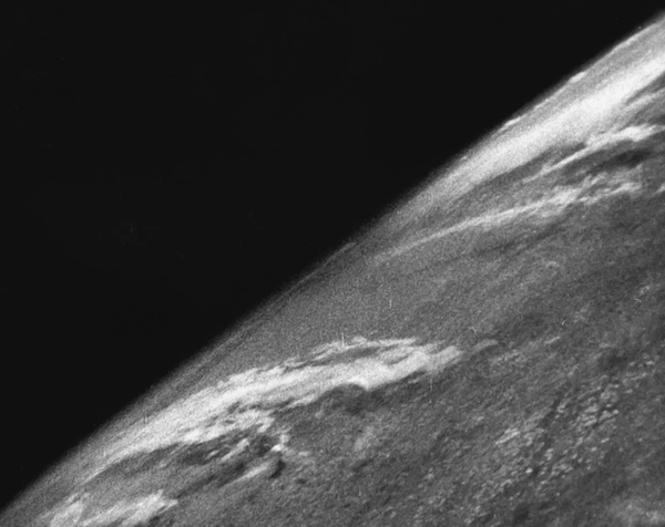 One of the first images taken from above the Earth's atmosphere. A camera in a V-2 rocket recorded this image in 1946. Later studies of these images were used to determine if photographing clouds from above would be useful for weather prediction. Early studies were inconclusive. (credit: US Army) |
Wizards of space
RAND was the first and most important of the many think tanks that so heavily influenced American defense policy during the Cold War. Established in 1946 by the Douglas Aircraft Company at the urging of the Army Air Force leadership, Project RAND was intended to provide suggestions on future technology to assist the Air Force. In its very first proposal produced soon after Project RAND was formed in 1946, RAND’s engineers recommended that the Air Force build an Earth-circling satellite. Meteorology and reconnaissance were the two primary missions for such a satellite.[2] But the cost of such a vehicle, and particularly the rocket needed to place it in orbit, was enormous, so the Air Force did not approve the project. For the next several years, RAND’s experts explored various aspects of the technology needed to make a satellite work, researching structures, engines, and propulsion. But these remained primarily paper studies.
| A weather satellite would be restricted largely to photographing clouds. But from a weatherman’s viewpoint in 1951, cloud pictures were largely useless. |
In April 1951, RAND experts produced the first of their two early comprehensive studies on the missions of satellites, defining in detail exactly what they could do from orbit. The first report, titled “Inquiry into the Feasibility of Weather Reconnaissance From a Satellite Vehicle,” evaluated the value of weather data that could be returned from a television-based weather satellite.[3] It was not an attempt to design a satellite, merely to determine if any of the data that it could collect would be useful for “weather reconnaissance.” The report's authors, William Kellogg and Stanley Greenfield, stated that, “in the event of armed conflict, aerial weather reconnaissance over enemy territory, similar to that obtained in World War II, will be extremely difficult, if not impossible. An alternative method of obtaining this information, however, is thought to lie in the use of the proposed satellite vehicle.”[4]
But Kellogg and Greenfield recognized that such a satellite would be controversial in the weather community. Meteorology relied upon direct measurement over large areas: wind speed and direction, air pressure, humidity, and temperature. Meteorologists gathered this data by going places and taking readings, or sending balloons up to do this for them. This information was incorporated into mathematical models to predict what would happen.
A weather satellite was different. It did not take direct measurements. It flew high above the atmosphere and took pictures. “It is obvious,” Kellogg and Greenfield wrote, “that in observing the weather through the ‘eye’ of a high-altitude robot almost all the qualitative measurements usually associated with meteorology must fall by the wayside.”[5]
A weather satellite would be restricted largely to photographing clouds. But from a weatherman’s viewpoint in 1951, cloud pictures were largely useless. The presence or absence of clouds provided only minimal data about the weather. Clouds did not often indicate wind direction or velocity, particularly at multiple altitudes. Because meteorologists considered clouds relatively unimportant, they had devoted little attention to their study. Only two years earlier, an article by Army Major D.L. Crowson in the Bulletin of the American Meteorological Society had addressed this dilemma. Crowson, using photographs from high-altitude V-2 rocket flights in the Nevada desert, argued that even low-resolution cloud imagery from high altitudes could be useful for weather forecasting. But Crowson’s 1949 article did not convince anyone that the limited information that could be collected was worth the costs either of using rocket flights to carry cameras to high altitude, or of taking the next step and developing a satellite and a rocket capable of placing it in orbit.
Kellogg and Greenfield decided to pick up the argument where Crowson had left off. They posited a satellite in a 350-nautical-mile (648-kilometer) orbit and equipped with a standard television camera and asked a very basic question: “Can enough be seen from such an altitude to enable an intelligent, usable weather (cloud) observation to be made, and what can be determined from these observations?”[6] They set up a simple test: they took some of the same data that Crowson had used and attempted to determine what the likely weather pattern was for the American southwest when the observations were made. They then compared their forecast based on the cloud data to the actual weather patterns reported on those dates. The results did not produce a clear endorsement of a weather satellite. They concluded that the data that could be obtained from cloud observations was limited, but this was due in part to the lack of scientific study of how clouds reflected weather patterns. With better information cloud photography might be more valuable, but that data could only be gathered with a satellite, a conundrum for meteorologists. Nevertheless, a weather satellite offered some unique advantages to meteorology, particularly for observing areas of the Earth for which little data was available. “Although ship reports and weather reconnaissance by aircraft help to some extent to fill the gap,” they wrote, “there has long been a need for extending weather observations over the oceans and inaccessible areas.”[7]
Such a satellite also meant that “extremely large areas may be visually observed in a relatively short period of time.” Furthermore, “for the first time in the history of synoptic meteorology, the classical models of various weather situations may be examined in toto.”[8] In other words, a satellite would help not just weather prediction, but the testing of weather models. It could be a research tool, not just a measurement instrument.
The bigger problem was that the Air Force leadership had no interest in satellites of any kind. Although the potential utility of satellites was murky, their expense was obvious. RAND was told to continue its studies and focus primarily on reconnaissance. But the Air Force would not start a program to develop actual hardware. By 1954, RAND produced a much more extensive report known as Feed Back, which evaluated the design and utility of a reconnaissance satellite. Feed Back led the Air Force to begin a reconnaissance satellite program in 1955 that it soon labelled Weapons System 117L, or WS-117L. But the project limped on for several years, grossly underfunded.[9]
In early 1956, the Air Force selected Lockheed to build the reconnaissance satellite instead of Martin Co. or the Radio Corporation of America, or RCA. In their contract proposals, both Martin and RCA had briefly mentioned meteorology as one possible use of a visual reconnaissance system, but they were primarily focused on the reconnaissance mission. Lockheed was given a contract to develop a reconnaissance satellite as part of WS-117L. But the program was underfunded and Lockheed was not provided sufficient money to proceed.
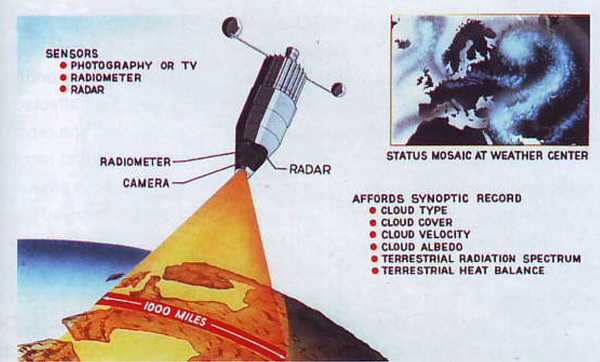 Although early studies of a satellite for meteorology used television cameras, soon scientists proposed adding additional instruments to image other atmospheric effects. This illustration is from 1959 or 1960 and shows a vehicle based upon the USAF’s Samos reconnaissance satellite and its Agena spacecraft. (credit: Lockheed via the NRO) |
A stationary front
For ten years starting in 1946, RAND's engineers had studied the problems of spaceflight and reconnaissance for the Air Force. But RAND’s studies were not limited to satellites. The think tank addressed many other subjects as well and, in December 1956, RAND produced another report that attempted to quantify how reconnaissance in general was affected by different weather conditions. The report had been prompted in part by the first reconnaissance robots, an aerial balloon project known as “Genetrix.” Genetrix involved releasing hundreds of balloons carrying cameras in Europe. Prevailing winds at high altitudes carried the balloons over the Soviet Union and upon reaching the Pacific Ocean they were commanded to drop their camera payloads for retrieval. Most of the balloons never made it, but for the few that did, many of their photographs were degraded by clouds.
| The bigger problem was that the Air Force leadership had no interest in satellites of any kind. Although the potential utility of satellites was murky, their expense was obvious. |
The robots could not determine if there was a cloud obscuring the target. RAND's study pointed this out and addressed the full spectrum of reconnaissance, from visual and infrared to radar, no matter what platform was used to carry the sensor. As the study's author noted, weather was a big problem for reconnaissance. But some areas of the globe were far more likely to be cloud-covered than others, and reconnaissance sensors such as infrared detectors or radar would be affected differently depending upon the type of weather phenomenon.
The author's primary conclusion, however, was that reconnaissance experts needed to further study the problem in detail, and at the very least develop a better definition of the problem and a unique set of weather criteria for different kinds of reconnaissance operations.
Current military weather criteria were insufficient. For instance, a military officer planning a reconnaissance mission would consider clouds over a target to be “critical weather,” whereas high winds would be unimportant. But a weatherman supporting a bombing mission might have little concern about clouds but consider high winds to be unacceptable.[10] In their losing bids for the reconnaissance satellite contract, both Martin and RCA had specifically addressed the problem of cloud cover over the Soviet Union, acknowledging that this would present a problem for a reconnaissance satellite. Both companies proposed satellites using television cameras, and both recommended solving the cloud cover problem essentially the same way, through brute force: launch enough satellites and take enough photographs and eventually all of the important targets would be photographed over a period of time. But such a brute force method would return massive numbers of photographs and some kind of automated sorting system would be required to assess them and discard cloud-filled photographs. Equally important, this could mean long delays to obtain photographs of certain areas.[11]
The Air Force WS-117L satellite program managers realized that a weather satellite would be useful, both to support worldwide Air Force operations, and to support their own reconnaissance mission. But WS-117L was severely underfunded in 1956 and 1957. The Air Force would not provide the program office, or Lockheed, with more than a fraction of the money necessary to build the satellite. With no money to pay for even the basic development of a reconnaissance satellite, they certainly could not consider developing a weather satellite to support it.[12]
What changed things was the October 1957 launch of Sputnik. Suddenly WS-117L was force-fed with money by the Air Force leadership. Soon Air Force officials split WS-117L into three programs known as Sentry, Midas, and Discoverer. Sentry was the reconnaissance satellite program, Midas was a missile warning satellite, and Discoverer was merely a cover story—essentially a lie—to conceal the CORONA reconnaissance satellite program. Sentry also began to evolve and grow. At first it consisted of only two basic satellite designs, the Pioneer and Advanced reconnaissance cameras. But by the end of 1958 its name had been changed to Samos and a year later it consisted of five different photographic payloads and two electronic intelligence payloads. Despite this growth, the Samos project office did not begin a weather satellite, and none of the cameras then under development would have been useful for providing cloud photography, primarily because they all photographed small areas of the earth rather than the vast areas covered by weather patterns.[13]
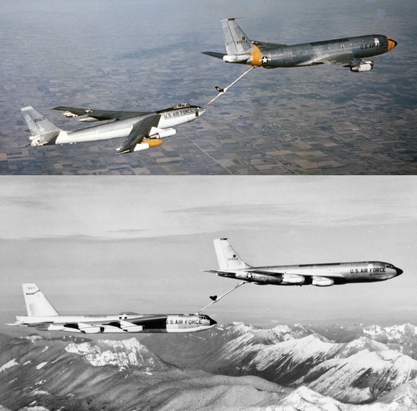 KC-135 tankers refueling a B-47 medium bomber and a B-52 Stratofortress. Weather reconnaissance was vital to planning successful refueling operations, and the Air Force had B-47s dedicated to collecting weather data. Despite the requirement and the existing cost of weather reconnaissance operations, the Air Force was slow to embrace the idea of a weather satellite to gather that data. (credit: USAF via Robert Hopkins III) |
Cloud reconnaissance
In late March 1959, Amrom Katz wrote a draft recommendation that the Air Force develop its own “cloud reconnaissance satellite.” In his summary he explained that “peculiar are requirements, close tie-in to classified and sensitive operations, and above all, requirements for timely data, all point to a system controlled and operated by USAF.”[14]
| What changed things was the October 1957 launch of Sputnik. Suddenly WS-117L was force-fed with money by the Air Force leadership |
Katz turned his attention to the need to supply weather information to the military services. “By and large, the example of the Pentagon notwithstanding,” Katz wrote, “these services work outdoors, where there is nothing but weather, which sometimes aids the services' work, sometimes hinders it.”[15] The Air Force needed timely weather data to support several missions. One high-priority mission was aerial refueling Strategic Air Command bombers. Aerial refueling requires that the pilots be able to see the tanker aircraft, which they cannot do in heavy clouds. A satellite could allow planners to pick good areas for the planes to rendezvous, a job that was complicated by the fact that the Air Force’s two different fleets of tanker aircraft operated at different altitudes with different weather conditions. In addition, a satellite might allow for planning nuclear bombing missions, because many aircraft designated to carry nuclear bombs had to rely upon visual location of their target.[16] Another important contribution of such a satellite would be for planning airborne reconnaissance missions. Many airborne reconnaissance sensors are “weatherlimited,” and such missions are both expensive and potentially dangerous. “It is a waste of an already meagre effort to take pictures of clouds on these missions,” Katz explained.
An additional mission was programming reconnaissance satellites. The Samos readout satellites scheduled to enter operation in two years would transmit their images to the ground over a 6-megahertz radio link, which was not much. Katz noted that the camera could theoretically photograph an area 36 to 40 times greater than its ability to transmit to the ground. “We envision the cloud recce satellite as an intimate partner of this long focal length video talk-back satellite,” Katz wrote. “A kind of cloud-spotter that says, ‘not now, Jack, save yourself for the next orbit.’”[17]
The final mission for such a weather satellite was providing information on clouds for recoverable reconnaissance satellites. They not only had the same need for cloud-free photography as the Samos readout satellites, but recovery operations to retrieve the satellite after re-entry also depended upon accurate weather information.[18] Katz then proposed a relatively simple modification to the existing Samos reconnaissance satellite to produce cloud photographs of larger areas. Several other modifications would be required, but Katz felt that the system could provide useful data at minimal cost and development time.[19]
Katz's proposal was soon followed by a second RAND study in April 1959 by one of his colleagues who argued that instead of using a film-scanning system, the weather satellite should use a television system.[20] By this time, a weather satellite using a television system was already underway, but the Air Force did not control it. Another military service did.[21]
Next: In part 2, the Air Force gets its weather satellite, and loses it.
References
- Thomas S. Blanton, “They Spy, But Why?” Newsday, Sunday, March 11, 2001, p. 5.
- Douglas Aircraft Co, “Preliminary Design of an Experimental World-Circling Spaceship,” Report No. SM-11827, May 2, 1946, contained in: John M. Logsdon, et. al., eds. Exploring the Unknown, Vol. I (NASA, SP-4407, 1996), pp. 236-244.
- S.M. Greenfield and W.W. Kellogg, “Inquiry Into the Feasibility of Weather Reconnaissance From a Satellite Vehicle,” R-218, The RAND Corporation, April 1951.
- Ibid., p. v.
- Ibid.
- Ibid., p. 2.
- Ibid., p. la.
- Ibid., p. 13.
- For more information on the early reconnaissance satellite development, see Dwayne A. Day et al, Eye in the Sky (Smithsonian Institution Press, 1998); see also James S. Coolbaugh, “Genesis of the USAF's First Satellite Program,” Journal of the British Interplanetary Society, August 1998, pp. 283-308.
- W.R. Cartheuser, “Weather Degradation of Reconnaissance,” D-4003, The RAND Corporation, December 10, 1956.
- Radio Corp of America, “Outline of a Development Plan for an Advanced (Satellite) Reconnaissance System for United States Air Force,” February 29, 1956; Martin Co., “Advanced Reconnaissance System,” January 15, 1956. (Originals at Defense Technical Information Center.) Both RCA and Martin lost the contract to build the WS-117L Advanced Reconnaissance System in January 1956, but these reports undoubtedly represent their bids for the contract.
- This is based upon conversations with several of the original WS-117L officers, who have said that simply getting enough money to pay for the reconnaissance mission was difficult. They could not bother with other missions like meteorology.
- See Eye in the Sky for further details.
- Amrom H. Katz. “An Air Force Weather Satellite - Why and How,” SOFS- STRATRECCE-1, The RAND Corporation, March 31, 1959, p. ii.
- Ibid., p. 4.
- Ibid., pp. 5-6.
- Ibid., pp. 6-7.
- Ibid., p. 7. Katz's mention of recoverable reconnaissance satellites in this document is notable. Katz and his colleague Merton Davies had proposed such a satellite in 1957. After it was formally started, they were told that it had been cancelled and were not allowed to know of its existence. However, by early 1959, Katz started to suspect the truth, that a covert project was underway under the disguise of the Discoverer program. His comments in classified documents like this one on the weather satellite quickly made many people nervous, and eventually Katz was questioned about what he knew of the CORONA program. He was then informed of its existence and after that had to stop mentioning the project outside of formal channels.
- Ibid., pp. 8-12. Katz apparently also described this system in a separate report, RAND D-6243, around the same time.
- J.H. Huntzicker, “An Air Force Weather Satellite Utilizing T-V,” D-6252, The RAND Corporation, April 6, 1959. This document references RAND D-6243.
- John H. Ashby, “A Preliminary History of the Evolution of the Tiros Weather Satellite Program, (HHN-45),” NASA, Goddard Space Flight Center, August 1964, NASA History Division.
Note: we are using a new commenting system, which may require you to create a new account.