A NASA-ISRO joint radar satellite finally launchesby Ajey Lele
|
| NISAR is a unique example of growing Indo-US relations in the space sector. |
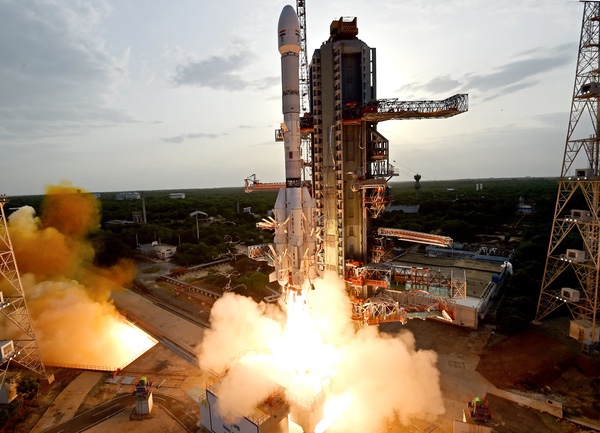
The first GSLV Mk II launch took place on April 18, 2001, and NISAR was the 13th launch mission for a GSLV Mk II vehicle. Unfortunately, this rocket has suffered four failures. It is important to note that on January 5, 2014, India achieved a major milestone with the successful launch of GSLV Mk II-V-D5, marking the country's first successful demonstration of indigenous cryogenic engine technology. This achievement was significant for India’s aspirations to develop reliable launch systems capable of deploying heavy satellites.
It seems the world has come full circle with this launch. The NISAR satellite is a joint project developed by NASA and ISRO. It was launched aboard a rocket powered by India’s indigenously developed cryogenic engine technology, the same technology whose transfer to India was once blocked by the United States! The development of this competence has been a long and challenging journey for ISRO, especially after a technology transfer agreement with Russia in the early 1990s was halted due to US pressure related to nuclear and missile proliferation concerns. Since 2001, ISRO has been independently developing cryogenic engines, overcoming several setbacks along the way. Today, it has achieved such a level of proficiency that even NASA has entrusted one of its satellite launches to an Indian launch vehicle powered by this technology.
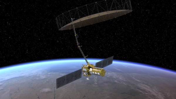 An illustration of NISAR in orbit with its large radar antenna deployed. (credit: NASA) |
NISAR is a unique example of growing Indo-US relations in the space sector. From design and development to launch, it took a decade for this mission to come to fruition. NASA was known to be toying with the idea of development of such unique and important Earth observation satellites since 2007. The idea became a reality when the NISAR partnership was officially forged on September 30, 2014, between NASA and ISRO. This satellite is meant for tracking fine changes in Earth's land and ice surfaces and will revisit the same spot every 12 days. It will detect minute (at the centimeter level) changes in the land and ice structures and coastal shifts. Both natural and human=induced land changes—owing to various farming practices and infrastructure projects like dams—could be continuously monitored by this satellite. NASA mentions that this satellite can give detect precursors to natural hazards like earthquakes, landslides, and volcanoes by picking up on tiny shifts in the vertical movement of the Earth’s surface as small as one centimeter. Also, a detailed study is possible in respect of subsidence and swelling, movements and deformations linked to melting of glaciers and ice sheets in Greenland and Antarctica. Much also could be learned about the forest fires and their spread.
| It becomes increasingly important for NASA to look outward and collaborate with likeminded nations such as India, which can bring not only technical expertise, but also financial resources to support ambitious joint missions. |
It would take around 90 days for this satellite to become fully operational. One of the most unique features of this satellite is that it has two radars, possibly the first such spacecraft in the world. NISAR utilizes two different radar frequencies: an L-band radar provided by NASA and an S-band radar built by ISRO. Each radar system is sensitive to features of different sizes and excels at detecting certain attributes. Synthetic aperture radar (SAR) can see through clouds and is known to operate in all lighting conditions, indicating a 24/7 data availability in all weather conditions.
- The L-band radar, with wavelength of approximately 24 centimeters, can penetrate deeper into forest canopies, soil, and ice sheets, making it ideal for studying forests, groundwater, and glacial movement.
- The S-band radar, with wavelength of approximately 10 centimeters, focuses on surface details, capturing fine details like crop growth, small seismic shifts, or landslide movements.
Both the radar signals will be transmitted to Earth using a 12-meter-wide antenna reflector built by NASA, which was launched in a folded state. This gold-plated mesh reflector will also capture the returning signals, which will carry valuable data about the surface features that reflected them.
To understand how using two radar frequencies helps, consider the example of vegetation monitoring. The L-band radar is well-suited for detecting taller vegetation like trees, while the S-band provides more accurate readings of shorter plants such as bushes and shrubs. By combining data from both bands, scientists can create a more detailed and accurate picture of forest cover under preview.
NASA’s contribution to the project is estimated at around $1.2 billion, while ISRO’s contribution stands at approximately $90 million. As a global leader in scientific research and space exploration for nearly six decades, NASA now finds itself at a crossroads. The recently released Voyager Declaration warns that sudden budget cuts could threaten decades of progress made by NASA in areas like space exploration and climate science. In this context, it becomes increasingly important for NASA to look outward and collaborate with likeminded nations such as India, which can bring not only technical expertise, but also financial resources to support ambitious joint missions.
Note: we are now moderating comments. There will be a delay in posting comments and no guarantee that all submitted comments will be posted.