Flashpoint Cyprus 1974: Cold War satellite reconnaissance and peripheral warsby Dwayne A. Day and Harry Stranger
|
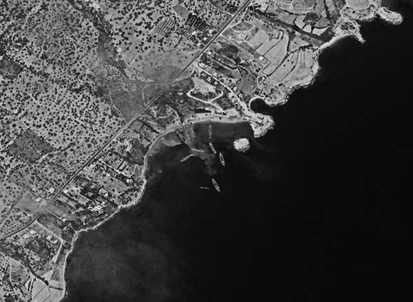
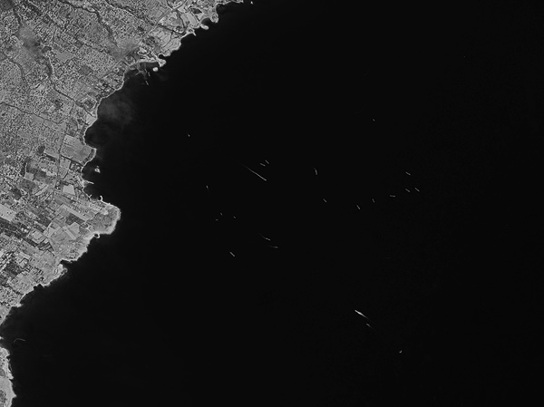 Multiple ships offshore during the invasion of Cyprus. This image was taken by a HEXAGON reconnaissance satellite on the day of the invasion, but was not seen on the ground until after it was over. (credit: Via Harry Stranger) |
The island derives its name from the Greek word for copper, “kypros,” which is present on the island along with other mineral resources as well as farm and grazing land. Greece and Turkey have long been rivals, and both countries had nationals living on Cyprus, with the majority being ethnic Greek. The political situation was complicated, and a United Nations peacekeeping force was also present on Cyprus, as were British military forces. The military junta in Greece ordered a coup against Cypriot president Archbishop Makarios III and installed Nikos Sampson. The Turkish government had expected the United States to prevent the coup, but Richard Nixon was in the final throes of the Watergate scandal and did not intervene. The results were not beneficial for the United States.
On Saturday, July 20, 1974, Turkish forces invaded Cyprus before dawn at Kyrenia (Girne) on the northern coast, meeting resistance from Greek and Greek Cypriot forces. Turkey claimed that it was protecting the Turkish Cypriots and guaranteeing the independence of Cyprus. The United Nations Security Council obtained a ceasefire two days later, by which time Turkish forces were in command of a narrow path between Kyrenia and Nicosia.
The ceasefire was tenuous, however, and three weeks later Turkey launched a second invasion, resulting in Turkey occupying 37% of Cyprus. A ceasefire line from 1974 separates the two communities on the island and is commonly referred to as the Green Line.
 Turkish forces invaded the island of Cyprus on July 20, 1974, and began heading toward the city of Nicosia and its airport. Multiple fires are seen in this photo taken by a HEXAGON reconnaissance satellite after the invasion started. (credit: Via Harry Stranger) |
Because both Greece and Turkey were members of NATO at the time, the United States Navy had a major presence in the Mediterranean, and the United Kingdom had forces on the island, there was substantial intelligence information about the invasion. The United States almost certainly had signals intelligence about the military activities, although SIGINT has its limitations, especially if an adversary knows somebody may be listening. The invasion happened so quickly, and the first action was over so soon, that it was undoubtedly difficult to keep up with the information that was flowing in.
What the United States apparently did not have was timely overhead photo-reconnaissance imagery of the invasion. The US Navy regularly operated in the Eastern Mediterranean and had tactical reconnaissance planes. But there is no indication that American aircraft were flying over Cyprus taking photos, and such missions would have been dangerous in a war zone, especially with both Greece and Turkey equipped with American aircraft and weapons. Near-real-time satellite reconnaissance technology was catching up but had not reached operational status.
What the United States did have, however, were satellites equipped with film. On April 10, 1974, the Air Force launched HEXAGON Mission 1208 from Vandenberg Air Force Base in California. The HEXAGON had two powerful cameras that could photograph large amounts of territory in a single sweep, providing a “god’s eye view” of a battlefield. On June 6, 1974, the Air Force launched GAMBIT Mission 4342 from Vandenberg. GAMBIT had a single incredibly powerful camera. It photographed a much smaller area than HEXAGON, but provided high-resolution detail enabling photo-interpreters to identify specific types of vehicles and military equipment.
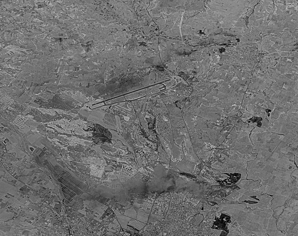
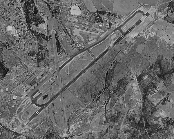 The Nicosia Airport was a major target for both Turkish and Greek forces. The Turkish Air Force bombed the airport to prevent it from being used by the Greeks. Several passenger planes were at the airport and can be seen on the runway. This photo was taken on July 24, after a ceasfire was in place. (credit: Via Harry Stranger) |
Both HEXAGON and GAMBIT were in orbit when the Cyprus invasion occurred. But because the satellites used film to record their images, this film had to be jettisoned in a reentry vehicle, recovered over the North Pacific Ocean, transported to Hawaii, then California, then Rochester, New York, for processing, and then delivered to Washington, DC, where trained interpreters looked at it through microscopes to identify military forces and equipment. It could take from days to weeks between when an image was taken and when it was seen on the ground. For fast-moving events like the invasion, the film arrived in Washington after the drama was over.
On July 19, concerned about a Turkish military attack, a Cypriot force was ordered to make a perimeter around Nicosia Airport. On July 20, as the Turkish forces began their invasion, Turkish planes also started bombing the airport.
On the morning of July 21, Turkish aircraft again attacked the airport. That same day, Greek military aircraft took off from Souda Air Force Base and headed toward Nicosia. Two of the planes diverted, but thirteen continued on. Early in the morning of July 22, they began landing at the airport, but one was shot down by mistake by friendly Cypriot forces who believed it was part of the Turkish invasion.
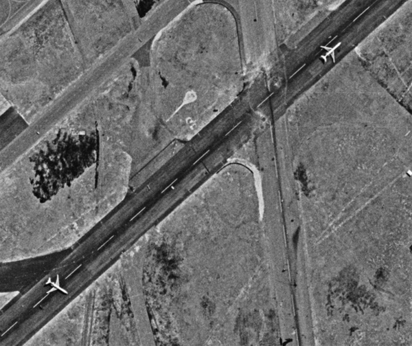 The Turkish Air Force was successful in temporarily putting the airport out of operation. Several craters are visible on the runway. The runway was also blocked by a destroyed Trident passenger jet. (credit: Via Harry Stranger) |
On July 22, the two sides agreed to a ceasefire. But the Turkish Air Force attacked the airport before the ceasefire, bombing the runway. After the ceasefire took effect, the Turkish Air Force, using two American-made F-100 Super Sabre and six F-104 Starfighter jets attacked the airport again, destroying a Cyprus Airways Trident passenger jet on the runway.
Small-scale ground fighting took place at the airport on July 23. Another Trident was damaged at some point, although it did not burn. Fifty years later it was still sitting on the long-abandoned airport grounds. Two other Tridents suffered minor damage, but were stranded at the airport until later flown out. One of them< a href="https://www.youtube.com/watch?v=VxIyQCAQi7g">now resides in a museum.
The HEXAGON reconnaissance satellite, the size of a school bus, flew over Cyprus on July 20 and photographed the landing force. On July 24, it photographed the airport. The photos were not returned to Earth until days later. Its photos show the invasion force in Kyrenia, burning structures at several locations on the island, and the still-burning wreckage of the Trident airliner on the runway.
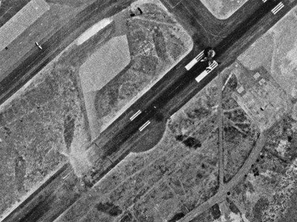 A July 24 photo taken by a HEXAGON reconnaissance satellite shows a still-burning Trident passenger jet on the runway at Nicosia Airport. The airport was attacked by Turkish forces multiple times after forces invaded on July 20, 1974. (credit: Via Harry Stranger) |
It is unknown if the high-resolution GAMBIT satellite also photographed Cyprus during the battle. Even without timely imagery, the United States would have had substantial other intelligence about the fighting, including signals intelligence intercepts, but satellite reconnaissance can show exactly where a military force is operating and what it is doing. Near-real-time satellite reconnaissance would not become available to the United States for another 16 months, with the debut of the KH-11 KENNEN satellite in late 1976.
Nixon resigned August 9, but other involved governments were also unstable. By the time of Turkey’s second invasion in August, the Greek military junta was imploding. The British government was also wobbly, suffering a hung Parliament, and unwilling to intervene. The political repercussions of the dispute were bad for the United States. Turkey’s government expected the United States to prevent Greece from taking over the island. When the American government failed to do so, Turkey invaded, and also halted activities at numerous American military bases throughout Turkey, including intelligence collection sites, a result that Secretary of State Henry Kissinger called “a disaster.” Afterwards, the British listening post on Cyprus assumed a much greater burden of intelligence gathering on behalf of the United States. (See: “Stonehouse: Deep space listening in the high desert,” The Space Review, May 8, 2023.)
Although largely forgotten by the rest of the world, the fallout from the Cyprus invasion over a half century ago affects the island’s inhabitants every single day. The HEXAGON’s photos are a reminder that the Eastern Mediterranean has often been the site of conflict.
Further reading:
- Turkish invasion of Cyprus.
- CIA, “Reported Movements of Greek and Turkish Forces Toward Cyprus,” July 16, 1974. CIA-RDP78S01932A000100070050-6
- National Intelligence Bulletin, July 17, 1974. CIA-RDP79T00975A026700010050-0
- The President’s Daily Brief, July 22, 1974. CIA-RDP79T00936A012200010019-1
- The President’s Daily Brief, July 24, 1974. CIA-RDP79T00936A012200010021-8
- CIA, “Status of Nicosia International Airport,” July 24, 1974. CIA-RDP78S01932A000100070077-7
- The President’s Daily Brief, July 30, 1974. CIA-RDP79T00936A012200010026-3
Note: we are now moderating comments. There will be a delay in posting comments and no guarantee that all submitted comments will be posted.