Mapping the dark side of the world (part 1): The KH-5 ARGON geodetic satelliteby Dwayne A. Day
|
| What makes a good reconnaissance camera is not what makes a good mapping camera |
But acquiring detailed maps of hostile terrain is a major challenge. For American military leaders during the early years of the Cold War, much of the Soviet Union was as uncharted as the dark side of the Moon. The United States had to rely on Soviet maps, many of which were either incomplete or deliberately inaccurate. The locations of mountains, rivers, lakes, and even whole cities were either unknown or highly doubtful. Without this knowledge, military operations were at risk. Indeed, without accurate maps of Soviet territory, ICBMs were very limited in their utility, except for blowing up large targets like cities.
Satellites offered a solution to this problem from the very beginning. Long before there was such a thing as civilian remote sensing, the United States military developed the means to map this dark territory, and did so behind its own cloak of secrecy.
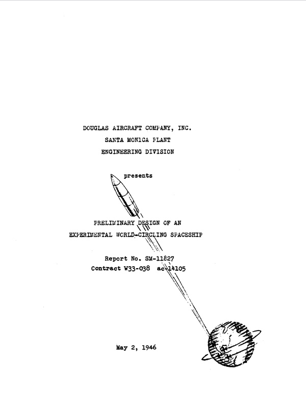 Cover of a 1946 report that outlined the possible missions and technologies for a satellite. Mapping from space was one of the early missions of interest to the US military. (credit: RAND Corporation) |
Early proposals
The US Air Force began studying the possible uses of a satellite for military purposes in 1946. At a time when space was no more than a Flash Gordon fantasy, a pioneering report by an Air Force contractor, the RAND Corporation, outlined the technologies and equipment necessary to place a satellite in orbit and the possible missions such a satellite could achieve. At this early stage, there was no clear ordering of priorities; the missions a satellite could perform were virtually limitless. A satellite could conduct bomb damage assessment: essentially looking for craters of nuclear weapons dropped on an enemy.[1] It could also be used for meteorology and communications. Finally, it could be used as a weapon, such as an orbital bombardment system. Despite this potential, the costs of developing a rocket to place a satellite in orbit were immense. The Air Force satellite remained a paper study for years.
By the early 1950s, Air Force officers such as then-Colonel Bernard Schriever, and policy and technology analysts at the RAND Corporation, soon turned their attention to the use of a satellite for reconnaissance and meteorology, focusing primarily on the benefits of the former. This grew out of an overall increasing interest in the values of strategic reconnaissance and aerial cartography. In 1951, the Director of Intelligence for the US Air Force stated that one of the intelligence requirements of any military reconnaissance satellite was to “Produce a photographic quality for the revision of aeronautical charts and maps.”[2] However, despite this requirement, no work was performed on this subject in a subsequent RAND report.
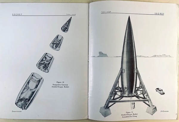 Illustrations from the 1946 RAND report on a satellite. Although V-2 rockets had flown ballistic trajectories during World War II, RAND demonstrated that a more powerful rocket could put satellites in orbit. (credit: RAND Corporation) |
In December 1953, the Air Force formally approved a preliminary satellite development program called MX-2226. By 1954, RAND produced a landmark report known as Project Feed Back. It was the first comprehensive study of the feasibility of a reconnaissance satellite, as well as the means of placing any satellite in orbit. Feed Back also specifically noted that satellites could be used for mapping purposes, but once again did not address the subject in depth. In 1956, Feed Back led to eventual approval of a full satellite development program given the designation Weapon System 117L, the Advanced Reconnaissance System. There were other mapping proposals as well, including one for the use of a Viking sounding rocket to map Antarctica, but the WS- 117L program was the only military satellite with formal approval. Unfortunately, the civilian Air Force leadership lacked the interest that the uniformed leadership had in the Advanced Reconnaissance System and it was severely underfunded in both 1956 and 1957.
At a basic level, the difference between a “reconnaissance” satellite and a “mapping” satellite is primarily a matter of scale. In theory, virtually any reconnaissance satellite is also a mapping satellite, since it can be used to plot terrain features. But cameras must obey a basic rule of optics: the higher the resolution of a reconnaissance camera, the narrower its field of view, and thus the less territory that can be photographed. For mapping purposes, resolution is not extremely important and it reduces the area that can be mapped.
However, there is a far more important criteria than scale which determines the difference between a mapping and reconnaissance camera. Amrom Katz was one of the fathers of the American reconnaissance satellite program. Katz outlined the distinct difference between a reconnaissance camera and a mapping camera when he stated in a secret Air Force report that “detail at a point is not nearly as important as maintaining and preserving the relationship between points…”[3] Katz noted: “Mapping photography is designed to give information about the character of the terrain; reconnaissance/intelligence photography is designed to give information about characters on the terrain.”[4] Thus, what makes a good reconnaissance camera is not what makes a good mapping camera. Resolution can be sacrificed for area coverage and for precision calibration. Because of these factors, separate reconnaissance and mapping cameras are usually developed for this purpose.
 The SAMOS E-1 camera took photos on film, developed the film in orbit, scanned the film, and transmitted the images to the ground. But E-1 was not suitable for mapping purposes. It did not cover enough territory and, in the words of one RAND physicist, its images were “rubbery.” (credit: NRO) |
From Feed Back to SAMOS
The authors of the 1954 Feed Back report proposed a television-based camera system with approximately 70–200 feet (21–61 meters) resolution and covering a swath width of 374 statute miles (602 kilometers) orbiting at an altitude of 300 nautical miles (555 kilometers).[5] This was not ideal for mapping purposes, but still had some utility. The cartographic uses of the proposed system were not explicitly discussed by the report's authors, but Feed Back convinced top Air Force officials that a reconnaissance satellite was both desirable and achievable.
| The SAMOS program managers naively believed that no one could make an acronym from its letters. Over seven decades of space programs have demonstrated that engineers can make an acronym out of any arrangement of letters |
In early 1955, the Air Force formally outlined the intelligence requirements for such a project, but it was not until summer 1956 that the Air Force proposed a contract for development of a reconnaissance satellite. The WS-117L program initially operated at Wright Air Development Center in Dayton, Ohio, but soon moved to Los Angeles. It was a small program, terribly underfunded by the Pentagon.
Everything changed after Sputnik. Satellite reconnaissance moved from the realm of fantasy to become the centerpiece of a revitalized American military space program. The program soon received the money and attention in the White House that its proponents had so desperately sought. A quicker, cheaper reconnaissance satellite, code-named CORONA, was spun off from the main program and placed under control of the CIA.
In 1958, the Air Force split WS-117L into three distinct programs: the MIDAS missile detection satellite, the Discoverer engineering development satellite (a cover story for the CORONA reconnaissance satellite), and the SENTRY reconnaissance satellite. By late 1958, the Air Force renamed SENTRY as SAMOS. SAMOS, which was not always spelled in all-caps, was not an acronym, but had been selected for two reasons: first, it was the mythical home of King Midas, and second, the program managers naively believed that no one could make an acronym from its letters. Over seven decades of space programs have demonstrated that engineers can make an acronym out of any arrangement of letters.
The WS-117L program managers abandoned the television approach very early on due to poor performance. SAMOS’s primary emphasis was on the development of a film-readout satellite for reconnaissance; the satellite would take a picture, develop the film in orbit, and then scan the film electronically for transmission to Earth. Eventually, program managers chose to develop two SAMOS spacecraft types, each based upon a different camera. These cameras were designated E-1 and E-2. The E-1 was to have a resolution of 100 feet (30 meters) and a swath width of 87 nautical miles (161 kilometers). The E-2 was to have a resolution of 20 feet (6 meters( and a swath width of 14.5 nautical miles (26.9 kilometers), demonstrating the tradeoff between resolution and area coverage.[6] But neither camera was designed for mapping purposes, and neither covered enough area to be very useful.
The visionary scientists at the RAND Corporation did not cease their advocacy of new and better satellite systems. They argued for a dedicated mapping camera as early as May 1958, in a report developed by Amrom Katz called “Notes on Potential Military Space Systems.”[7] Apparently as a result of this report, SAMOS program managers soon added two more camera systems to the SAMOS project. These were known as E-3 and E-4. E-3 was a different approach to developing the imagery on orbit and never progressed very far. E-4 was a dedicated mapping camera, and its mission was commonly referred to as geodesy, although during these early years mapping, charting, and geodesy were often lumped together in discussion.[8]
The SAMOS E-4 program involved the Air Force’s Ballistic Missile Division (which oversaw the WS-117L program), the Wright Air Development Center’s Aerial Reconnaissance Laboratory, Rome Air Development Center, and Lockheed Missile System Division. WS-117L program managers began defining and designing a camera useful for geodetic work.[9] But by May 1959, the program was ordered canceled, although it really ended up in limbo for several months.
Around this time, the US Army and the Advanced Research Projects Agency began work on a project apparently known as APOLLO. They then gave two contracts to the General Electric Corporation known as projects SALAAM and VEDAS. These were studies of mapping satellites using reentry vehicles. General Electric at that time was responsible for the reentry vehicle for the CORONA spacecraft. The VEDAS program became the primary geodetic satellite program around mid-1959. The name APOLLO was apparently not used after this time, and SALAAM, which was often used interchangeably with VEDAS, was used infrequently. (SAMOS E-4 will be discussed in the third article of this series.)
Enraged pioneer
Amrom Katz was a physicist and optical specialist at the RAND Corporation. He was also a character. In July 1946, he was stationed at Bikini Atoll in preparation for photographing the first atomic bomb test there. Like everybody else on the tiny island, he was bored. Katz also had access to the regular resupply flight to the island and put in a secret special order—for some horseshoes and horse manure protected in dry ice. After the shipment arrived, one night he and an accomplice walked across the island stamping horseshoe prints into the sand and occasionally leaving some droppings. In the morning, the other residents of the island wondered where a horse had come from, and where it had gone.
| Over the next several years, Katz found himself excluded from most of the overt Air Force WS-117L and SAMOS programs as well. But from his view at RAND, his understanding of the bureaucratic politics surrounding the program was probably quite accurate. |
In addition to his sense of humor, Katz had a lot of exasperation with Air Force bureaucracy that came through many of the memos he wrote about Air Force subjects. Beginning in 1956 Katz became one of the primary advocates within RAND for using satellites for reconnaissance purposes. Katz advocated the idea of a recoverable satellite and he is properly considered one of the fathers of this idea. The Air Force adopted this proposal in late 1957, designating it “Program IIA.” Program IIA was formally cancelled in early 1958, with much protest from Katz. What Katz did not know was that his proposal had been adopted, but that the program was made highly covert and he was excluded from it (although two and a half years later Katz would be briefed on the system).[10] Katz’s loud protestations about the cancellation of the recoverable satellite program helped convince people that it really was canceled.
Over the next several years, Katz found himself excluded from most of the overt Air Force WS-117L and SAMOS programs as well. He therefore was not aware of the intimate details of the SAMOS program in 1959. But from his view at RAND, his understanding of the bureaucratic politics surrounding the program was probably quite accurate. As he stated: “Occasionally, at perigee, and briefly, we have something to do with the program. Most of the time we dwell near apogee - far from the program, and lonely. From this position, many of the details are hard to see, but the perspective is terrific.”[11]
Some aspects of the state of the SAMOS E-4 program during the first half of 1959 and Katz’s knowledge of it remain unknown. According to Katz, after the SAMOS program was started, the WS-117L program office attempted to prove that the existing approach to reconnaissance they were developing was also ideal for mapping purposes. As Katz stated: “From their Olympian heights of psychological insecurity, they let contracts through their agents at RADC [Rome Air Development Center] to prove that the 117L system as conceived could indeed produce maps. Their position was simply this: the 117L system was still not loved by everyone, and extravagant claims had to be made. Certainly the claim that 117L couldn't do everything had to be fought and opposed, as a subversive heresy. Not at all surprising in view of the terms of the contract, and the interests of the contractors, two contractors did produce reports purporting to demonstrate that maps could be made from 117L photography. All it would take, it appears, is (a) very good luck, (b) a prodigious amount of precise data, including orbital positions and (c) a tremendous amount of computation and mathematics. Of these three ingredients, the only one whose availability could be counted on is the last.”[12]
Because of these inauspicious beginnings, Katz argued, the seeds of failure for SAMOS E-4 were already sown: “The simple fact of the matter is that the rubbery narrow angle photography produced by 117L is simply not the right way to make maps.” In addition, those involved in the decisions about SAMOS E-4 in spring 1959 could not agree on the proper orbit for the satellite. Katz and RAND argued that the satellite should fly in a very high orbit—1,000 nautical miles (1,850 kilometers)—to maximize mapping coverage. But the WS-117L program office preferred to fly the satellite in a 300-nautical-mile orbit, the same as its other planned reconnaissance satellites. Katz felt that this was stubbornness on the part of the leaders of the program office. He was also frustrated at the lack of support for his position from the other involved parties: the Air Force's Aeronautical Chart and Information Center (ACIC), the Wright Air Development Center (WADC, home of the Aerial Reconnaissance Laboratory), the Rome Air Development Center (RADC), Ballistic Missiles Division (BMD), and Lockheed. As he stated with his usual irreverent flair:
“ACIC's position must have gone something like this: look, we’re glad to be in this act – we’re glad that anyone wants to work on our problems - and after all, 300 miles is a hell of a lot better than the five, six or seven miles of airplane altitudes, and further, the difference between three hundred and a thousand miles is small compared to the basic fact of satellite mapping, so let’s not argue – let’s not rock the boat. WADC’s position was somewhat similar: we’re damn glad to get brought into the satellite business after starving for so many years and being frozen out, let’s not argue with our bosses at BMD, let’s get on with the job. Lockheed’s position is pretty obvious: they’re all for any mapping satellite because this means more contract, more satellites, more production, etc.”
Katz knew about the SAMOS E-4’s cancellation, but was almost certainly unaware of the Army’s SALAAM/VEDAS program. From Katz's point of view, the whole SAMOS E-4 had been nothing but a mess. As he summed up: “Well, here’s another good idea which had a rough infancy, a miserable childhood, and, after winning social acceptance, got cut down in its prime. We know the old saw ‘You can't win ’em all.’ OK, but why lose the good ones?”
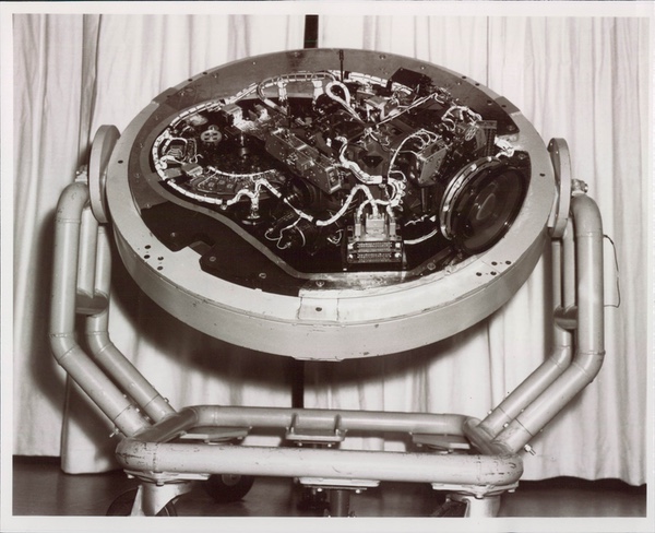 The ARGON program was started in 1959 to use a film camera and a recoverable capsule developed for the CORONA reconnaissance program for mapping purposes. The ARGON camera took photos of large areas of the Earth that had high-fidelity, meaning that the distance between any two points on an image were consistent. (credit: NRO) |
ARGON
What Katz did not realize was that he had not lost the argument. By spring of 1959, the SAMOS E-4 program had effectively come to a halt. Just like his earlier arguments that had led to the film-return satellite, Katz had been right once again: the Air Force approach was unworkable, and another program was begun in great secrecy.
The full details of the SAMOS E-4 program during early to mid 1959 are unknown. Also unknown.is why the sponsorship of a geodetic satellite shifted from the Air Force’s Aeronautical Chart and Information Center to another organization. The US Army Map Service (AMS) was responsible for all American military mapping outside of the continental United States. It had an excellent relationship with the CIA and was actively using U-2 photography for mapping purposes. One of its major projects was making photomaps from U-2 images for use in Tibet, where the CIA and the Army were running a large covert operation.[13]
The US Army Corps of Engineers had also sponsored work at the Willow Run Laboratories of the University of Michigan. This work was labelled Project MICHIGAN and in 1957–1958, both the Project MICHIGAN staff and the WS-117L contractors had collaborated, evaluating the use of satellites for mapmaking.[14]
By summer 1959, the geodetic satellite program which was sponsored by both the US Army and the Advanced Research Projects Agency and was known as VEDAS, faced a problem. The satellite would use the same film return technique as CORONA but was not nearly as highly classified. It therefore jeopardized the Discoverer cover story for CORONA. DoD and CIA officials agreed to cancel VEDAS and recreate it under another name, ARGON. This program would use the same security and contractors then involved in CORONA. It would be entirely covert.
 ARGON was one of a family of camera systems that used the reentry vehicle and other systems of the CORONA reconnaissance program. (credit: NRO) |
ARGON Begins
ARGON began in August 1959, at a time when a handful of CORONA research and development and operational test flights had already taken place. Army Colonel Charles Ruzek was placed in charge of the ARGON program in September 1959, which he initially managed from Washington, DC, as part of the Advanced Research Projects Agency. Ruzek reported to Nick Golovin in the Advanced Research Projects Agency, then later to Bruce Billings in the Department of Defense’s office of the Deputy Director of Research and Engineering (DDR&E). Ruzek had considerable background in geodesy, having served in and commanded several Army Engineer Topographic Battalions. He had also been the Executive Officer of the Army Mapping Service.[15] He was briefed about the CORONA program by a CIA officer and also told about the U-2 overflight program. Ruzek considered ARGON to be a challenge. “We were breaking new ground,” he said.[16]
Although the program was formally managed by an Army officer, ARGON was placed within the security framework of the CORONA program. ARGON utilized the same spacecraft upper stage as CORONA—the Agena—and also the same basic structure and reentry systems. The integration of all the systems was done at the covert Lockheed Advanced Projects facility at East Palo Alto, California. The main difference between CORONA and ARGON was the camera.
| Mahon’s urgency represented a little-recognized fact of the missile age: ICBMs were only as accurate as the targeting and geodetic data provided to them. |
The CORONA camera then being produced was known as the “C” camera and was based upon a concept developed by the Itek Corporation of Boston, Massachusetts, which also manufactured the lenses. Fairchild Camera and Instrument Company (FCIC) at Syosset, Long Island, New York carried out the actual design and production of the CORONA camera as a subcontractor to Itek. The Army selected FCIC to produce the ARGON camera as well, with the Perkin-Elmer Corporation supplying the lenses.[17]
Unlike the panoramic CORONA camera, the ARGON camera was a single-frame design. It had a three-inch (7.5-centimeter) focal length and exposed a single frame that was 4.5 inches (11.4 centimeters) on a side (the film was five inches, or 13 centimeters, wide). As the shutter opened, a tiny amount of nitrogen was released behind the film. The combination of vacuum on one side and slight pressure on the other ensured that the film sat flush against the film platen containing a reseau grid located at the focal plane of the camera.[18] Film would leave the supply cassette which was above the camera, travel through the camera, and then continue forward into the take-up cassette inside the Satellite Recovery Vehicle (SRV). The SRV would jettison its heat shield after reentry and a film-return “bucket” containing the take-up cassette would float toward the ocean on a parachute, and would be snatched out of the air by a C-119 recovery aircraft.
ARGON was also equipped with a second camera for taking star images. This was referred to as the Stellar camera (usually capitalized in documents) and it was vital to the mapping mission. To accurately locate ARGON’s images on the Earth, the geodesists needed to obtain precise data on the location and orientation of the spacecraft (i.e. exactly where the camera was pointing). The Stellar camera provided this information by taking an image of the starfield at the same moment that the mapping camera photographed the ground. The Stellar camera had a three-inch focal length and a two-inch (five-centimeter) diameter circular format. It also recorded a binary time readout from an on-board clock. It was angled 10 degrees above the horizon.[19]
Because the Stellar camera provided information on the orientation of the mapping camera, its precise angular relationship to the mapping camera had to be accurately measured. FCIC’s engineers calibrated the cameras by taking the equipment to a precisely known astronomical observation site (either the Lowell or Palomar observatories) and taking simultaneous photographs of the stars with the Stellar and terrain cameras. This allowed them to calculate the angular relationship between the camera axes.[20] A cartographer could incorporate all the relevant data from the orbital track and Stellar and terrain cameras, and obtain precise mapping coordinates (i.e. latitude and longitude).
The early Discoverer/CORONA missions, which began in February 1959, all used the Agena A upper stage.[21] To reach a higher orbit, ARGON required the more powerful Agena B upper stage then in development. This higher orbit was better suited for the geodetic mission, but was still significantly below the orbit recommended by Katz and others at RAND in the late 1950s. But CORONA was the pioneering program, and it had to fly before ARGON would follow it into orbit
An urgent mission
Throughout 1959 and 1960, CORONA suffered a dozen failures before finally achieving its first success on August 18, 1960. On this same date, Colonel James E. Mahon of the Joint Chiefs of Staff (which consisted of the uniformed leaders of the four military services) wrote a top-secret memo to the Committee on Overhead Reconnaissance (COMOR).
COMOR was an interagency committee responsible for selecting the targets for American reconnaissance missions. By extension, it was also responsible for determining the schedule of launches. Mahon’s memo stated:
“The national requirements for reconnaissance and geodesy are both critical and it is difficult to assign relative priorities, i.e. reconnaissance is urgently needed to assess the threat of the USSR, and the geodetic locations must be acquired to ensure effectiveness of weapons systems in being, or soon to be deployed, as well as to maintain an effective deterrent posture.”
“It is proposed that the COMOR recommend to the CORONA and ARGON operators that, if it is technically feasible, at the earliest possible date a CORONA shot with the C’ (“C Prime”) camera and Agena B engine be utilized to obtain reconnaissance of the whole of Russia… to be followed as soon as possible by the ARGON camera with Agena B engine to fulfil geodesy requirements. While it is recognized that the implementation of this recommendation would alter the schedule established for these programs, the COMOR view is that the urgency of both national strategic targets (the objective of CORONA) and the geodesy requirements (ARGON) are of such urgency as to warrant the change in schedule if compatible with sound technical communications.”
Mahon’s urgency represented a little-recognized fact of the missile age: ICBMs were only as accurate as the targeting and geodetic data provided to them. Without accurate information on both the shape of the Earth and the precise location of the target on the Earth, the missile was shooting blind. Even if its guidance system worked perfectly, it might hit far from the actual target location.
By the late 1950s, military geodesists knew the accuracy of most targets within the Soviet Union to only two to three miles. This inaccuracy was added to the guidance system inaccuracy of the Atlas, Titan, and Minuteman missiles then under development. Without the data provided by satellites, ICBMs were practically useless weapons against military targets, although they could still be used to target large cities. ICBM accuracy soon increased rapidly, driving a requirement for better geodetic data.
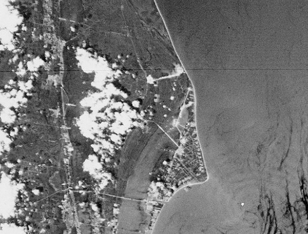
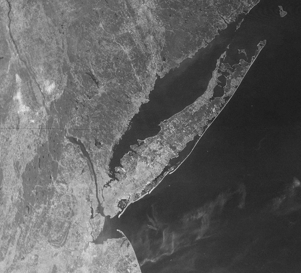 An ARGON mapping satellite image of Long Island, New York. Although these images could be enlarged to reveal details like cities and bridges, they were primarily used to create maps. (credit: Harry Stranger) |
ARGON flies
The Air Force launched the first ARGON mission atop a Thor Agena B rocket on February 17, 1961. Officially and publicly known as Discoverer XX (“Discoverer 20”), it had a secret name known to only a few, CORONA Mission 9014A—A for ARGON. Like all early CORONA flights, it flew under the cover of the Discoverer program. Discoverer was nothing more than a clever deception to hide the CORONA program.
| ARGON demonstrated the need for accurate satellite tracking and led to the development of a computer program to determine accurate orbital ephemeris data. |
Mission 9014A successfully reached orbit and its camera operated as planned. On February 21, the Satellite Recovery Vehicle disconnected from the spacecraft, but due to an on-board malfunction, the SRV ejected half an orbit away from the recovery area northwest of Hawaii. It reentered over the Indian Ocean, far from recovery forces. Assuming that the reentry sequence operated successfully and the parachute deployed as planned at 60,000 feet (18,300 meters), the film-return “bucket” containing the film would have floated in the ocean for approximately 24 hours before filling with water and sinking. The first ARGON mission had failed.
The second ARGON mission, 9016A, was launched on April 8, 1961. On April 10, it too ended in failure when the deorbit retrorockets fired in the wrong direction and boosted the SRV into a higher orbit. The SRV stayed in orbit for a year before eventually reentering. Two more attempts, on June 8 and July 21, also ended in failure. The first was due to an Agena malfunction and the second to a Thor rocket failure.
Despite the urgency stressed by Colonel Mahon in his memo to COMOR, after these early disappointing results, ARGON did not fly again for nearly ten months. The pressure diminished at least in part because by mid-1961 CORONA had shown the Soviet ICBM threat to be virtually non-existent (although the matter was not definitively settled until late 1961). Urgency had also probably diminished due to a better understanding of the limits of accuracy of American ICBMs. By early 1962, Colonel Charles Ruzek had transferred to El Segundo, California, and the Air Force Office of Special Projects, where he ran ARGON and was the Deputy Director for Geodesy. He looked on the early ARGON failures as proof of Murphy's Law. The problems were fixable, it would just take brain power.[22] Unlike CORONA reconnaissance satellites, which flew year-round, ARGON only flew during the summer months, so Ruzek had a long time to wait before he would get the chance to fly again.
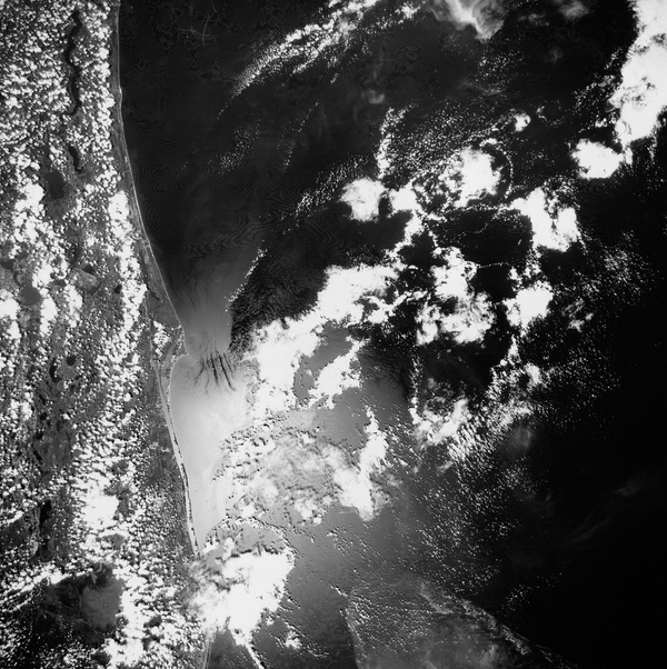  In August 1963, ARGON overflew Florida and photographed Cape Canaveral, including the missile and rocket launch sites there. This may be the first U.S. satellite image of the launch facilities. (credit: Harry Stranger) |
The fifth mission, 9034A, launched on May 15, 1962, was a complete success and was recovered four days later. By this time the newly created National Reconnaissance Office, which was ostensibly in charge of American reconnaissance satellites, applied a new designation system to the reconnaissance satellites. Each camera system was· given a KEYHOLE designation followed by a number. Early CORONA missions were thus designated KH-1, 2, 3, and 4, and ARGON was designated KH-5.
Operationally, the ARGON satellites flew in a slightly higher orbit than their CORONA counterparts. Also, unlike CORONA, which turned its camera on only while over a target, the ARGON cameras operated continuously throughout a flight because each image covered a greater amount of territory and used less film.[23] Because of this, much of the imagery was cloud-covered and not usable.[24] Estimates for the percentage of cloud cover in early CORONA missions were about 50–60% and ARGON imagery would have been similar. This greatly improved by the end of the CORONA program in 1972, when only about 27–30% of the imagery was obscured by clouds.
The ARGON camera provided a resolution of approximately 450 feet (137 meters). Beginning in April 1963, the satellites utilized the more powerful Agena D upper stage and in October they used the even more powerful Thrust Augmented Thor (TAT) with its three solid rocket motors providing extra thrust. ARGON, like CORONA, soon began operating on a regular basis.
After the successful May 1962 mission, another mission in September ended in failure but was followed by another success in October. An April 1963 mission again ended in failure, but was followed by successful missions in August and October of 1963. These missions flew in approximately 95-degree polar orbits, with perigees of around 157 nautical miles (291 kilometers) and apogees around 351 nautical miles (650 kilometers). Program managers suspended ARGON launches during the winter months (although CORONA missions continued), and resumed them with two launches in June and August of 1964. The two 1964 missions went into highly retrograde 115-degree orbits. These last two flights carried the Starflash optical beacon, which was part of an unclassified geodetic mission.
ARGON Ends
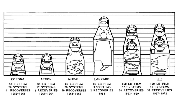
A total of 12 ARGON missions were launched from February 1961 until August 1964. Six of these were successful. ARGON demonstrated the need for accurate satellite tracking and led to the development of a computer program to determine accurate orbital ephemeris data.[25] However, ARGON was not the first American space photographic system to be used for mapping the Earth. That system will be discussed in the next part of this series.
Acknowledgements
The author would like to acknowledge the assistance of the following people in the preparation of this account Charles Ruzek, Frank Madden, Amrom Katz, William Harris, Dick Buenneke, Bill King, Dino Brugioni, and Charlie Murphy.
Endnotes
- Albert Wheelon, “CORONA: The First Reconnaissance Satellites,” Physics Today, February 1997.
- Major General C.P. Cabell, Director of Intelligence, USAF, to Colonel B.A. Schriever, Assistant for Evaluation, Air Research and Development Command, March 17, 1951.
- A.H. Katz, “More on the Mapping Satellite: Some Recent History for the Record, October 1, 1959,” D(L)-7169, February 8, 1960.
- Amrom H. Katz, “Airborne Photography,” Photogrammetric Engineering, Vol. XIV, No. 4, December 1948, pp. 484-590.
- J.E. Upp and R.M. Salter, "Project Feed Back Summary Report,'' AF 33(038)- 6413, The RAND Corporation, March 1954, p, 18, 95. Author’s note: The United States has rather stubbornly refused to convert to the metric system and all measurements on American reconnaissance programs are in English units of measurement, which I have prserved here. To convert the measures to metric, I am providing the following figures: One statute mile equals 5,280 feet or 1.609 kilometers. One nautical mile equals 6076 feet or 1.852 kilometers. One foot equals twelve inches or .3 meters. One inch equals 2.54 centimeters. My apologies for the absurdity of this situation.
- “SAMOS Special Satellite Reconnaissance System,” United States Air Force, n.d., Office of the Staff Secretary: Records of Paul T. Carroll, Andrew J. Goodpaster, L. Arthur Minnich and Christopher H. Russell, 1952-61, Subject Series, Alphabetical Subseries, Box 15, “Intelligence Matters (14) [March-May 1960],” Dwight D. Eisenhower Library.
- Apparently no copies of this report, RAND Memorandum-2179, exist. It is mentioned in another RAND report A.H. Katz, “More on the Mapping Satellite: Some Recent History for the Record 1 October, 1959,” O(L)-7169, The RAND Corporation, February 8, 1960.
- Bill King interview with Dwayne A. Day, March 28, 1996.
- “Geodesy” is defined as the study of the shape and size of the Earth's surface. It is the most demanding of the mapping sciences and is required for most advanced military missions, particularly ICBM targeting.
- Letter from William R. Harris to Dwayne A. Day, May 5, 1997.
- A.H. Katz, “More on the Mapping Satellite.”
- lbid.
- Dino Brugioni telephone interview with Dwayne A. Day, May 14, 1997.
- Letter from William R. Harris, to Dwayne A. Day, May 5, 1997.
- Letter from Charles Ruzek, to Dwayne A. Day, April 18, 1996, p.1.
- lbid.
- Frank J. Madden, The CORONA Camera System: ltek’s Contribution to World Security, (self-published monograph) October 1996, p. 20.
- Bill King, interview with Dwayne A. Day, 28 March 1996.
- Letter from Charles Ruzek to Dwayne A. Day, January 21, 1997, p. 2. The DISIC camera used on the KH-4B CORONA satellite was reported to be “virtually identical” to the earlier ARGON camera, according to those who worked on the later program. DISIC actually had two Stellar cameras.
- Letter from Charles Ruzek to Dwayne A. Day, January 21, 1997, p. 2.
- The first three launches did not include a camera, but were still part of the CORONA program.
- Letter from Charles Ruzek to Dwayne A. Day, April 18, 1997.
- Charlie Murphy, interview with Dwayne A. Day, December 5, 1996.
- Dino Brugioni, interview with Dwayne A. Day, November 6, 1996, and Charlie Murphy, interview with Dwayne A. Day, December 5, 1996.
- Letter from Charles Ruzek to Dwayne A. Day, January 21, 1997.
Note: we are now moderating comments. There will be a delay in posting comments and no guarantee that all submitted comments will be posted.