Seeing through the storm: SAR imagery’s evolution beyond defense applicationsby Kateryna Sergieieva
|
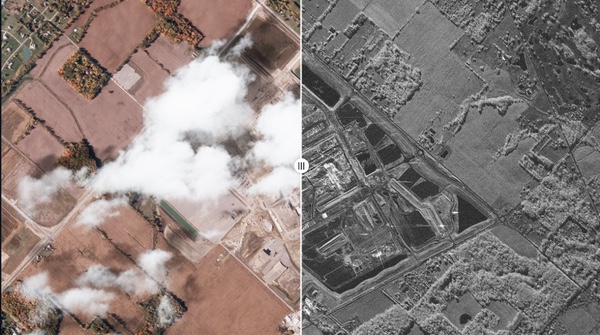
| SAR is increasingly crucial for emergency managers, who finally can have eyes on the ground after a hurricane or earthquake. |
For decades, SAR was largely used by militaries, but that’s over. Commercial operators sell high-resolution SAR images straight to the public now, with growing demand for such imagery. The physics explains the appeal: radar pulses pass straight through smoke, storms, and darkness, conditions that blind an ordinary optical camera. So, for disaster responders, SAR is not optional anymore.
Defense and intelligence: the traditional anchor
Defense and intelligence remain SAR’s largest market. In December 2025, Germany signed a €1.7 billion deal with Iceye and Rheinmetall to build a sovereign SAR satellite network. Poland, the Netherlands, Portugal, and Finland have all signed similar deals.
Japan’s IHI Corporation began receiving its first operational images in 2026 from two ICEYE-built satellites, the opening phase of a contract for four satellites with an option for 20 more. They are part of a sovereign Earth-observation push that Tokyo ties directly to monitoring vessel activity and protecting supply chains across the region.
The reason for such popularity is rather simple: radar doesn’t stop working because the sky is overcast or the sun has set. Open-source analysts have taken full advantage of that to track aircraft carrier construction inside Chinese shipyards and watch troop buildups near contested borders, cross-referencing commercial SAR images with shipping data.
Disaster response: seeing through the storm
SAR is increasingly crucial for emergency managers, who finally can have eyes on the ground after a hurricane or earthquake. Clouds from storms can blind optical satellites but SAR doesn’t have that problem. It sees straight through the weather that grounds everything else.
During major flood events, SAR imagery has become the tool of choice for mapping and directing rescue crews to where the water actually is, not where a map from six hours ago said it was. NASA and ISRO built their joint NISAR mission around this exact use case, designing it to hand decision-makers actionable SAR data for disaster response and agricultural monitoring. Greece didn’t wait for a joint mission: it deployed two of its own Iceye SAR satellites specifically to speed up response to floods, wildfires, and landslides.
Infrastructure monitoring: protecting critical assets
Pipelines, ports, and power plants can’t shut down for a sandstorm. Manual inspections and scattered ground sensors can’t keep pace with assets that run 24/7 in remote terrain, as they’re slow, costly, and often catch problems after they’ve already become expensive to fix.
| Point a satellite at the same target for a few extra seconds, and the radar starts picking up motion too small to see with the eye. |
This is where high-resolution SAR imagery benefits. Taskable radar satellites capture detail through darkness, cloud cover, and sandstorms alike. Capella Space’s constellation, for instance, can image the Port of Fujairah—one of the busiest bunkering hubs outside the Strait of Hormuz—at one-meter resolution, picking out terminal layout and vessel traffic at midnight as clearly as at noon.
Pipelines get the same benefit. Paired with thermal and hyperspectral sensors, SAR catches the soil discoloration or gas plumes that signal a leak already underway. Detect those leaks early, and you can cut methane emissions from oil and gas operations by up to 70%.
Maritime awareness: tracking the invisible fleet
Today, some companies run illegal fishing operations, smuggling routes, or sanctions-evasion schemes, hiding their vessels from radar at sea. However, SAR satellite images can highlight “dark vessels” that stop transmitting signals to evade detection. That assists investigations by border enforcement agencies and sanctions monitors.
New Zealand is pushing the concept further with low-cost floating radar reflectors designed to help space-based SAR spot people lost at sea: a real answer to the problem of searching 30 million square kilometers of ocean for a single boat or swimmer. In the Pacific Ocean, that can be the difference between a rescue and a recovery.
The next frontier: micro-motion detection
SAR used to freeze the world in a single frame: one image, one moment, nothing more. That’s changing. Point a satellite at the same target for a few extra seconds, and the radar starts picking up motion too small to see with the eye. That includes phenomena such as an engine idling, a bridge swaying slightly, or a gear turning inside a machine. Each of those tiny movements leaves its own signature in the radar phase data, which is what lets analysts detect them from orbit.
Researchers proved it in Glasgow, picking up the idle vibration of a parked van and matching it to an 87-hertz reading from an accelerometer bolted to the vehicle. They’ve done the same with moving ships, extracting not just position but also behavioral clues: what the vessel is actually doing, not just where it sits. Micro-motion detection turns SAR imaging from a mapping tool into a diagnostic one, capable of identifying vehicle types or flagging failing infrastructure before it fails.
Conclusion
Every example highlights the main point: the ability to see through weather, darkness, and distance saves lives. A decade ago, these technologies were not widely accessible for civilians. But today we finally can track a carrier under construction, guide a flood rescue, and watch a pipeline through a sandstorm, all without approval from military or intelligence services.
Iceye alone has launched 62 satellites since 2018. Capella and Umbra have built out fleets of their own. Together, they’ve taken a capability that once belonged to a handful of governments and put it up for anyone serious to order. The debate has shifted from whether SAR is useful to determining who else can’t afford to be without it.
Note: we are now moderating comments. There will be a delay in posting comments and no guarantee that all submitted comments will be posted.