The watchers and the warning: what a Himalayan flood asks of Golden Domeby Bharath Gopalaswamy and Daniel Dant
|
| The failure is the absence of the layer that should sit between the camera and the person at risk, the layer that turns an observation into a decision and a decision into a warning that arrives while there is still time to move. |
We are a space-security scholar and a retired military officer, and we write ordinarily about missile defense, satellites, and the architecture of homeland protection. We do not write about Himalayan disasters, and we do not claim any standing to speak for the communities of Rasuwa and Nuwakot, whose grief is their own. We write because of something we could not stop considering in the days after the flood, and because we believe it bears directly on decisions the United States is making right now about how it defends itself from the sky. The world watched this disaster happen from orbit. And watching, it turned out, was not the same as warning.
Seen from space, in time, and still too late
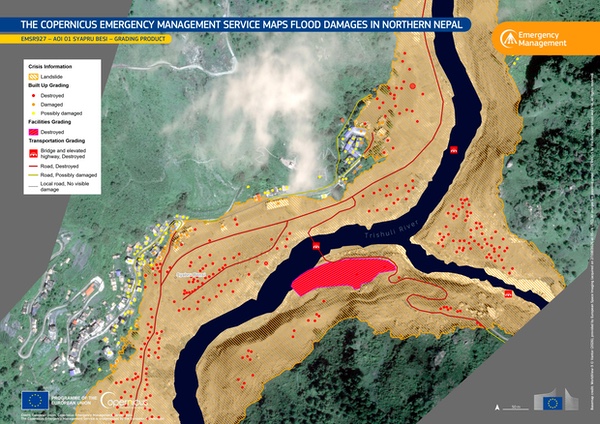
Within hours, the imagery was everywhere. Planet Labs captured the before and after. The European Union’s Copernicus Sentinel-2 satellites stitched together the sequence of the flood’s descent. The International Charter on Space and Major Disasters activated, as it does for catastrophes of this scale, marshaling the world’s Earth-observation assets to map the damage. By any measure of sensing, the system worked. The glacier, the blockage, the surge, the ruined crossings: all of it was observed, recorded, and understood with remarkable speed and clarity.
It is worth being precise about how well observed this region is, because it changes where the problem lies. This is not a corner of the world starved of satellites. India operates one of the most capable civil and security Earth-observation fleets in existence, including high-resolution optical and all-weather radar spacecraft. China fields an extensive constellation of its own across the same skies. Europe’s Sentinels stream openly and globally. Commercial operators image the entire Himalayan arc, in many cases daily. Between them, the states and companies with eyes on these mountains possess an abundance of observation that would have been unimaginable a generation ago. We raise this not to ask why any of them did not sound an alarm, which would be both unfair and beside the point. With all of that capability trained on the region, the warning still did not reach the valley in time. That tells us the frontier is no longer detection. It is everything that must happen between the observation and the person in the water’s path.
The satellites documented the disaster but did not avert it. This is not a failure of the cameras or of anyone operating them. The failure is instead the absence of the layer that should sit between the camera and the person at risk, the layer that turns an observation into a decision and a decision into a warning that arrives while there is still time to move. That layer is the hardest part of any sensing enterprise to build, because it is not a matter of better optics or more satellites, of which the region has many. It is a matter of fusing many signals, judging which ones matter, and acting at machine speed under the pressure of minutes. It is, we have come to believe, the same problem the United States is now spending a great deal of money and attention trying to solve for an entirely different threat.
The same gap, in a different sky
Golden Dome, the homeland missile-defense architecture now taking shape, rests on a foundation of space-based sensing: a proliferated layer of satellites in low Earth orbit to track threats, a data backbone to move what they see, and interceptors to act on it. In our earlier writing we have argued that the part of this architecture most likely to determine whether it succeeds is neither the sensors nor the interceptors, but instead the decision layer between them, the command and control that must fuse thousands of tracks, judge intent, prioritize, and assign a response in the seconds available, while a human retains authority over the choice to act. Detection, we wrote, without a pre-rehearsed decision chain, may simply document an attack.
| The case for building durable decision and warning infrastructure, rather than improvising after each disaster, grows stronger with every season. |
Nepal is that sentence rendered in water instead of fire. The threat could not be more different, a warming glacier rather than a hostile missile, but the shape of the failure is identical. Observation outran decision. The sensors saw more, and sooner, than the systems and institutions below them could turn into a timely act. If that gap is the thing that will decide whether a missile-defense architecture protects American cities, it is also, we now see plainly, the thing that decided how many people in a Himalayan valley had a chance to reach high ground. The engineering challenge that keeps defense planners awake is, underneath, a humanitarian one as well.
What would close the gap
Stated as an architecture rather than a lament, the missing layer has recognizable parts, and none of them require a single new satellite. The first is fusion across owners and borders: a means to combine what Indian, Chinese, European, and commercial sensors each see into one coherent picture, so that no single operator must detect an unfolding event alone. The second is automated triggering: change-detection and threshold logic that can recognize a glacier collapse or a sudden river rise and raise an alert without waiting for a human analyst to notice, because in a thirty-minute flood there is no time for a human to be the first to notice. The third is pre-delegated dissemination: agreed channels and authorities that carry a validated warning the last mile, to the district officer and the village, before anyone convenes a meeting to decide whether to send it. The fourth, and the hardest, is institutional: the cross-border data-sharing arrangements that let one nation’s observation lawfully and instantly become another nation’s warning. The technology for the first three exists. The fourth is a matter of will, and it is where the greatest lives-per-dollar return almost certainly lies.
There is an example of this approach. Israel has built, and operates at national scale, close to the most mature example of the architecture this argument calls for. Radar detects a launch, an automated system computes where it will fall, and within seconds a location-specific alert reaches the civilians in its path, by siren and by a warning pushed to their phones, telling them how long they have to reach shelter. The interceptors of Iron Dome are the part the world sees, but the part that saves the most lives is quieter: the chain that turns a sensor reading into a person moving to safety, resolved in the seconds that are all anyone has. Where the Nepal flood shows the gap between seeing and warning at its widest, the Israeli civil-alert system shows the same gap closed. The architecture is not aspirational. It exists, it functions under fire, and it demonstrates that the hard problem—detection turned into a decision turned into a warning at the last mile—is solvable when a society decides to solve it. What remains, for Himalayan valleys as for homeland defense, is the will to build it where it does not yet reach.
It would be a comfort to treat the Nepal flood as a freak occurrence, a once-in-a-generation collapse. It is not. Glacial-lake outburst floods of this kind are growing more frequent as the high mountains warm, as meltwater works deeper into the ice and weakens the bonds that hold rock and glacier together. Nepal has now suffered damaging floods with a glacial signature in successive years, and the Rasuwagadhi crossing was struck by a smaller flood only last year. What was once rare is becoming a recurring feature of life along these rivers, which means the warning problem is not a problem to be solved once but a permanent condition to be lived with. The case for building durable decision and warning infrastructure, rather than improvising after each disaster, grows stronger with every season.
The architecture we build for war should also serve the vulnerable
Here is the argument we most want to make, and we make it with care. The United States is about to build one of the most capable space-based sensing and decision enterprises in history, and it is building it for national defense. That is a legitimate and necessary purpose. But the capability at the heart of it—the fusion of many sensors into a fast, trustworthy decision—is not intrinsically military. The same architecture that could tell a command center which of a thousand tracks is a genuine threat could also tell a district officer in Rasuwa that the river will rise nine meters in half an hour.
| The same architecture that could tell a command center which of a thousand tracks is a genuine threat could also tell a district officer in Rasuwa that the river will rise nine meters in half an hour. |
The expertise the United States is developing to build machine-speed decision layers over a proliferated sensing base is precisely the expertise a multinational disaster-warning system needs, and which the region’s existing satellites already place within reach. We treat these as separate problems, funded through separate channels, one as security and one as disaster relief, the first lavishly and the second on whatever is left. The flood is a reminder that they are, at the level of the underlying capability, the same problem.
We are not proposing that missile-defense satellites be redirected to flood duty, or that humanitarian need justify a defense program or vice versa. We are proposing something more modest and, we think, more durable: that as the nation designs the decision architecture above its sensing layer, it designs it in the knowledge that the same capability serves more than one mission, and that the hard-won craft of building it can be shared with the civil-warning effort at little cost to the defense one. Built narrowly, for war alone, it would waste a chance to protect the vulnerable at the margins where a warning is the difference between an evacuation and a funeral. A decision layer built with that breadth in mind is not a weaker instrument of defense. It is a wiser one.
In the days after the flood, the images that stayed with us were not the satellite composites, striking as they were. They were the views from the valley floor: excavators clearing sludge from where homes had been, mud to the rooflines in Trishuli, families waiting for news that in too many cases came from far downstream. The people of Rasuwa and Nuwakot did not need to be told that a glacier had failed. They needed 30 minutes, and a voice telling them to climb. The world’s satellites, of many nations, saw the water coming. The distance between that seeing and that voice is the whole of the problem, and it is the problem we are now, for our own reasons, spending a fortune to solve. We should solve it in a way that would have reached the valley too.
Note: we are now moderating comments. There will be a delay in posting comments and no guarantee that all submitted comments will be posted.