Billiards in spaceby Brian Weeden
|
| Some pundits have put forth the notion that Iridium had maneuvered to avoid another object and wandered into the path of Cosmos 2251. Others have speculated that a tiny anti-satellite pushed Cosmos 2251 into Iridium 33’s path. There is no factual basis for either of these scenarios. |
I feel it is important to first elaborate on my background to establish my credibility on this issue before proceeding to discuss the satellite collision. From 2004 to 2007 I was a captain in the United States Air Force stationed with the 1st Space Control Squadron (1 SPCS) in Colorado Springs. 1 SPCS operated the Space Control Center (SCC) deep inside Cheyenne Mountain, responsible for tracking all man-made objects in Earth orbit and producing the satellite catalog for the US military. In May 2005, the SCC became part of the newly created Joint Space Operations Center (JSpOC) and in late summer of 2007 it was moved from Cheyenne Mountain to Vandenberg Air Force Base in California to join the rest of the JSpOC.
During my time with 1 SPCS, I was originally certified as an orbital analyst, an individual responsible for tasking the US military’s Space Surveillance Network (SSN) to track objects in Earth orbit. We also used that data to analyze space events and update the satellite catalog. Within a year of arriving I began instructing other orbital analysts and by 2006 had taken over the entire orbital analyst training program. During this time I also ran the monthly training for the entire squadron and developed tactics, techniques, and procedures for various special events and day-to-day operations. While I was not one of the small cadre of civilian analysts entrusted with performing conjunction analysis, I was fully aware of the procedures and worked closely with those that were.
Separating fact from fiction
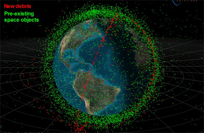
The facts known about this collision are as follows. On February 10 at 1156 EST, Iridium lost contact with one of its satellites, Iridium 33. They contacted the JSpOC at Vandenberg requesting help with resolving the anomaly. Using their network of radars, the JSpOC confirmed that there were two breakups, one corresponding to the inclination of Iridium 33 and another in a different inclination, later discovered to be that of Cosmos 2251.
While the two satellites were in relatively close inclinations, 86° for the Iridium and 74° for the Cosmos, the difference in their right ascension meant that their orbits intersected at almost a 90° angle close to the North Pole. So even though each object was traveling at around 7.5 kilometers per sec, the combined velocity at the moment of impact was around 10 kilometers per second.
What is unknown is how much overlap there was between the two objects at the moment of contact. This is extremely important for determining how much debris was created. If only a few protruding pieces were in contact, then the debris generated from this event is likely to be relatively low (on the order of tens to a few hundred trackable pieces). If a significant amount of the bodies of the two satellites were in contact, then it is likely that a couple thousand pieces of trackable debris were generated. It is unlikely that the event generated debris on the order of the Chinese ASAT test because of the extremely low probability of 100% overlap between the two satellites and the comparatively low collision velocity.
Some pundits have put forth the notion that Iridium had maneuvered to avoid another object and wandered into the path of Cosmos 2251. Others have speculated that a tiny anti-satellite pushed Cosmos 2251 into Iridium 33’s path. There is no factual basis for either of these scenarios, and in fact inquiring minds can verify this by checking the last several positions for each object published in the Space Track catalog. Doing so will show no appreciable changes in position of either object before the collision. This can be further verified by analyzing the velocity distribution of all the post-event pieces of debris and calculating the position and velocity of the parent objects at the moment of impact.
Both of these conjectures seem to stem from the false assumption that the US military has perfect knowledge about the objects in Earth orbit and is looking at every one for possible collisions. Therefore, a sudden orbital change at the last minute would be the only way to escape their vigilance. As I will explain later in this article, this is assumption is not true.
Others have speculated that the US military is concentrating its tracking efforts on only the smaller pieces of debris and thus wasn’t paying close enough attention to the big pieces. Again, that does not hold up to scrutiny. If anything, it is more important to track the big pieces because their larger surface area means they are more likely to be collision candidates and would create a much bigger debris cloud if they indeed hit. They are also much easier to track and it would be criminal not to expend the rather low amount of resources to keep their positions updated.
The realities of conjunction assessment
One public estimate as to the magnitude of the collision problem in low Earth orbit comes from an interview in December 2007 with an Air Force lieutenant colonel at the JSpOC in California who stated that in the average week “there will be up to 200 incidents where a piece of the Feng Yun [1C] passes within 3 miles [5 kilometers] of one of America’s 400 satellites”. As he was only referencing the conjunctions with the 3,000 pieces of debris created by the Chinese anti-satellite test, we can assume that the number of close approaches from all pieces of debris for all of the estimated 900 payloads in Earth orbit is potentially much higher.
Another data point comes from Centre National d’Etudes Spatiales (CNES), which does daily collision screening for 15 French satellites in low Earth orbit. In a presentation given in February 2009 in Strasbourg, France, a representative said that in 2008 they had 881 close approach alerts, of which 344 were actual risks (defined as having a probability of greater than 1 in 10,000). Out of all of these risks, 13 were determined to be potential collisions (greater than 1 in 1,000) and 2 required avoidance maneuvers (greater than 1 in 100).
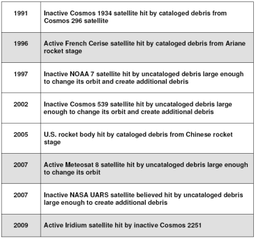 |
Given the hundreds to thousands of close approaches among the entire satellite catalog every day, it is surprising to note that there have only been eight known collisions. The table above, compiled by Dr. David Wright of the Union of Concerned Scientists, lists all the known accidental collisions between two objects in space. The three highlighted in gray involved active satellites. Many of these were not detected until long after the event occurred—the Cerise was actually the first known collision in space.
The huge difference between the number of close approaches and actual collisions means is that there is a significant false positive rate—there are many more non-threatening events than there are actual threat events, and sorting through the chaff to find the wheat presents a daunting analytical challenge.
| Given the hundreds to thousands of close approaches among the entire satellite catalog every day, it is surprising to note that there have only been eight known collisions. |
The process for protecting satellites from collisions involves two separate concepts: conjunction assessment (usually abbreviated CA) and collision avoidance (usually abbreviated COLA). Conjunction assessment is the process of determining close approaches between two objects, assessing the probability of collision and providing warning to satellite owner-operators. Collision avoidance involves a cost-benefit analysis of the risk posted by the close approach and whether or not to perform a maneuver to decrease the risk to an acceptable level.
Each day, the JSpOC screens a pre-determined list of satellites for conjunctions. This list consists of a subset of the estimated 400 US payloads in space. The objects with the highest priority are the human-related spacecraft, such as the International Space Station, Soyuz, and Shuttle, followed by critical military and intelligence satellites across all orbital regimes. Several NASA satellites are also on the list, including the remote sensing satellites that make up the A-Train.
An initial screening of this list of objects is done using fast computational methods to determine any close approaches which meet a certain threshold within a certain time period, usually four to seven days into the future. Beyond this time the cumulative inaccuracies greatly reduce the utility of the analysis. Any satellites that have a close approach within this warning threshold are then re-screened using a very precise numerical analysis that takes considerably more computing power. At this point, the SSN is also usually tasked to provide updated positions on both objects with the highest possible accuracy.
The end results are carefully screened by human analysts for high-probability conjunctions. Each satellite owner-operator may have different risk thresholds for what they consider to be a dangerous approach. For the International Space Station, NASA has defined the warning box as 5 km by 25 km by 5 km (radial, in-track, cross-track), which corresponds to a probability of collision of 1 in 100,000. The box within which evasive maneuvers will be considered is 2 km by 5 km by 2 km. These boxes are different from those NASA applies to unmanned scientific payloads and which others apply to their screened payloads.
The main limitation on how many satellites can be screened by the US military is trained personnel, with computational resources and sensor network capacity being secondary and tertiary limitations. The computers do all the heavy calculations, but it is up to the human analyst to determine if the answer makes sense and is correct. Intimate knowledge of the numerical techniques behind this process is required, along with considerable experience with both conjunction analysis specifically and space surveillance in general.
With rare exceptions, active duty military personnel do not develop the skills to perform this task. At most, they will be in a particular location for a three- or four-year tour and within that tour they are likely to have multiple jobs. The military promotions system demands incremental moves within a tour to various leadership, instructor, or evaluator positions to demonstrate suitability for promotion. Staying in the same job for an entire tour is considered evidence of someone who doesn’t have “the right stuff” and is a potential death knell for any career. There is also a strong prejudice against analysts in the officer ranks. During my time in the job, the position of Orbital Analyst was changed to Space Surveillance Director because the general in charge demanded it, stating that “officers aren’t analysts, only leaders or managers”.
It should be noted that these jobs are not done solely by officers: enlisted personnel are also part of the personnel pool assigned to these positions. And often times, despite their lack of a college education, there is no shortage of diligent and intelligent analysts coming from the enlisted ranks. That is a testament to the quality of personnel that the Air Force is able to attract and retain.
| There is a significant cost to maneuvering to avoid every close approach, and satellite owner-operators need to have a decision-making process in place to perform a cost-benefit analysis for their specific mission. |
Even if a dedicated, competent, military professional is willing to sacrifice their career to spend an entire tour doing just one job, they are unlikely to have the required mathematical or analytic background for conjunction analysis. The vast majority of space operators, the career field that provides personnel to these billets, are trained to follow set procedures and given only a few months of background training before being certified. Many come from jobs other than orbital analysis and will never have to do orbital analysis again in their careers. Thus, they have neither the tools nor incentive to develop the vital mathematical and analytical skills needed for this job.
It’s all about the data
The entire satellite protection process outlined above relies completely on the quality of data fed into it. The primary source of this data for the US military is the Space Surveillance System (SSN), a network of 29 globally-distributed optical telescopes and radars managed by the JSpOC. One of these sensors tracking an object in orbit and determining its position at a moment in time is called an observation. Multiple observations strung together in the same pass as the satellite flies overhead are called a track.
The JSpOC determines how many tracks of data are nominally required to maintain each object’s orbit based primarily on the object type, size and the rate of change of its orbit (called energy dissipation rate). These requirements are then fed into an algorithm along with the sensor availability. The algorithm assigns satellites to sensors in the network. During the next day, the sensors will schedule their assigned satellites for tracking and transmit the data back to the JSpOC. This data is used to update the element set for the object, and then the entire process is repeated.
An element set is a mathematical expression that allows calculation of a satellite’s location at a moment in time as well as calculation of its predicted position forwards and backwards in time. The US military maintains two separate catalogs of element sets. One stores the orbital positions of objects as Two-Line Elements (TLEs). The mathematical techniques behind the generation of TLEs were first outlined in a seminal 1980 paper by Hoots and Roehrich (which were fully explained in another paper in 1998). The analytical process behind TLEs uses general perturbations (GP). A perturbation is a natural force that changes a satellites orbit, such as the drag caused by the Earth’s atmosphere, the gravitational attraction of the Sun and Moon, and the asymmetric shape of the Earth. In the general perturbations model, these forces are averaged out along the entire orbit to give the average position of the satellite at any one moment in time. This is perfectly fine for acquiring a satellite for tracking, but not for conjunction assessment or other high precision tasks.
The second catalog, called the high accuracy catalog, stores the orbital positions of object as state vectors. However, unlike the TLEs, these state vectors are generated using special perturbations (SP) techniques. These techniques calculate many separate perturbations at many points along a satellite’s orbit and the satellite’s position at each. The resulting ephemeris file gives an extremely accurate position of the satellite along its orbital path that appears as a jagged line instead of a smooth arc. What is critically important for conjunction analysis is that this process also creates a covariance matrix for each state vector. This matrix can be thought of as the error inherent in the state vector measured in both position (x, y, z) and velocity (xdot, ydot, zdot).
The covariance matrix allows analysts to calculate the precise probability and geometry of a close approach, but it does not give an absolute yes or no answer as to whether or not two objects will collide. It is impossible to do this because of the inherent errors in tracking objects hundreds of kilometers away moving at speeds in excess of 7 kilometers per second, combined with the uncertainties in future prediction caused by orbital perturbations.
This covariance matrix not only allows for an accurate risk assessment, but also allows for the calculation of the collision avoidance maneuver that makes the most efficient use of fuel and has the least disruption to the satellite’s mission. This is perhaps the most important element of the entire process. A satellite that runs out of fuel cannot maneuver, and in many cases ceases to be of any value. More important, many satellites utilize precise ground tracks or pointing to perform their missions, and avoidance maneuvers are likely to disrupt data collection or create end-user outages. This means there is a significant cost to maneuvering to avoid every close approach, and satellite owner-operators need to have a decision-making process in place to perform a cost-benefit analysis for their specific mission. The risk of collision, and thus loss of the entire satellite, must be balanced against the cost in fuel, and thus reduction in lifespan, and the interruptions to the satellite mission.
page 2: sins of omission and commission >>
Google