The numbers gameWhat’s in Earth orbit and how do we know?by Brian Weeden
|
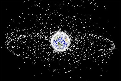
| Right now the world knows a lot less than half of what it should about the space environment. |
The other major category, artificial orbital debris, consists of the leftovers from humanity’s activities in Earth orbit. Every time we put a satellite into space, we end up leaving something behind in Earth orbit. At the very least this is the satellite itself and often times also includes one or more rocket stages and bits of miscellaneous stuff, like explosive bolts, lens caps, and solid rocket exhaust particles. Sometimes these leftover bits themselves shed more pieces through what are called fragmentation events. These events can be minor (a few dozen pieces) to extreme (explosions creating more than a thousand pieces). Within this category of artificial objects we define three basic populations: the trackable, the potentially trackable, and the untrackable.
Table 1 summarizes these definitions and estimated populations. The trackable population is generally defined as those objects ten centimeters in diameter or larger, as these are the current limits of the majority of the currently available tracking sensors. The potentially trackable population is generally defined as those objects between one and ten centimeters in diameter which can be tracked by some current sensors but not often enough to enable cataloging and future prediction at this time. Notably, the Haystack and Goldstone radars operated by the Massachusetts Institute of Technology (MIT) and NASA’s Jet Propulsion Laboratory (JPL), respectively, can track objects down to a few millimeters in size given the right conditions, but they only collect a few hundred hours of data each year. Additional sensors are planned for the near future that could provide the capability to track objects in this category more reliably, such as the S-Band Fence. The untrackable population generally consists of those objects smaller than one centimeter. As with the natural object population, the size of the untrackable artificial population can be estimated using models derived in part from examining satellites brought back from space.
Table 1: Population sizes of objects in Earth orbit
| Category | Definition | Estimated Population | Potential Risk to Satellites |
|---|---|---|---|
| Trackable | Greater than 10 cm in diameter | 19,000+ | Complete destruction |
| Potentially Trackable | Greater than 1 cm in diameter | Several hundred thousand | Complete to partial destruction |
| Untrackable | Less than 1 cm in diameter | Many millions to billions | Degradation, loss of certain sensors or subsystems |
NASA uses the term Micrometeoroid and Orbital Debris (MMOD) to talk about the entire population of natural and artificial objects that could potentially threaten satellites and human activities in space. In general, the main concerns from a safety standpoint are the trackable and potentially trackable populations because of their size. Due to the extremely high orbital velocities, and thus momentum, it is considered impractical to shield against impacts from objects bigger than one centimeter. So objects larger than one centimeter pose a significant risk for total satellite destruction or mission failure. The risk due to potential impacts from objects smaller than one centimeter can be mitigated in some fashion through shielding and satellite design, and generally present risks for only damage to a satellite or subsystem and not total destruction.
Observations, tracks, and catalogs
A satellite catalog is a database which contains a list of objects in orbit, information about those objects such as date and country of launch, and orbital data that describes the position of the object. There are multiple satellite catalogs in use across the world, but the most well-known and publicly available catalog is the one maintained by the US military, traditionally referred to as the SATCAT (military shorthand for satellite catalog). This catalog and others like it are a critical part of space situational awareness (SSA), which is knowledge about what’s happening in space.
A version of the SATCAT is available publicly through the Commercial and Foreign Entities (CFE) program on the Space Track website and provides positional data on the locations of objects in the form of Two-Line Elements (TLEs). Anyone in the world can sign-up for a free account to view, sort, and download this data, with the main restriction being redistribution of the data without prior approval from the Department of Defense (DoD). There are also other websites that have permission to redistribute this data, notably Celestrak and Heavens Above. These two sites receive the same TLEs from the US military that are on Space Track and are authorized to redistribute them, with the main distinction being that Celestrak and Heavens Above sometimes add additional information that isn’t found on Space Track.
Usually in a satellite catalog there is a set of descriptive data for each object. The launch date and launching State are two very important pieces of this data for legal reasons. According to the Liability Convention of 1972, the launching State is considered legally responsible for that object during the launch, on-orbit, and reentry phases and may have absolute liability or fault-based liability for damages caused by the object. The Convention defines the term launching State two ways:
(c) The term "launching State" means:
(i) A State which launches or procures the launching of a space object;
(ii) A State from whose territory or facility a space object is launched;
In the case of the recent Iridium-Cosmos collision, both objects were launched using Russian boosters. However, legally Russia was the launching State for the Cosmos satellite and the United States for the Iridium satellite because a US company, Iridium Satellite LLC, procured the launch and operated the Iridium satellite.
Determining the launching State for each of more than 19,000 objects in orbit currently being tracked is an extremely daunting task. The US military tackles this through a process of “cradle to grave” surveillance, meaning that they attempt to maintain an orbital history of an object from the moment it is launched to the moment it re-enters the Earth’s atmosphere. It should be noted that this does not mean every object is continuously tracked all the time: the technique employed is one of periodic spot checks to determine an object’s position at various points.
| Determining the launching State for each of more than 19,000 objects in orbit currently being tracked is an extremely daunting task. |
The entire process starts with good data coming from a network of sensors. The US military operates a worldwide network of optical and radar sensors called the Space Surveillance Network (SSN). The network is managed by the Joint Space Operations Center (JSpOC) located at Vandenberg Air Force Base in California. Raw data from SSN sensors flows into the JSpOC where they are collated and through a series of calculations turned into equations called element sets that describe the locations and movement of objects in orbit. Keeping the positions of orbital objects in equation form is very useful because it allows the user to propagate the position forwards and backwards in time to see where the satellite was in the past or will be. These element sets are constantly updated through a process known as catalog maintenance1 to make sure that they are as current as possible.
This entire tracking and cataloging process starts with the “birth” of a satellite when it is launched into space. A space launch is simply a more powerful version of a ballistic missile launch, and the Defense Surveillance Program (DSP) satellites in geostationary orbit (GEO) and the Space-Based Infrared Systems (SBIRS) in highly elliptical orbit (HEO) are designed to detect and track both using infrared sensors. By knowing the latitude of the launch site and the heading of the booster, the inclination (or plane of the orbit relative to the Equator) the satellite will end up in can be calculated using some relatively simple trigonometry.
Once the inclination of the object is known, those SSN sensors that will be overflown in the course of an object’s orbit can be determined. These sites are given a heads-up notice and asked to look for a new object or objects coming into their tracking range in that inclination. Once initially detected, the sensor collects a series of observations, called a track, on the object as it passes through the coverage of that particular sensor. These observations are used to determine an initial element set describing the object’s orbit. However, at this point the element set is usually very inaccurate since it only has one track of data covering only a small section of the orbit. So it is passed to subsequent sensors which are tasked to collect addition observations. As more tracks are collected from different points around the object’s orbit the position becomes more and more refined. Once this positional accuracy reaches a certain quality, the object is then ready to be entered into the catalog.
Satellites heading into deep space orbits such as GEO (36,000 kilometers above the Earth) present a different problem as they usually require multiple orbit changes and maneuvers. Some can take several weeks to arrive on station depending on the method used. Each time a maneuver is performed the process of initial discovery by a sensor, creation of an initial element set, and refinement of that element set needs to be repeated. Sometimes the satellite owner-operator will provide a burn plan which has all the scheduled maneuver times and post-maneuver orbital elements. This helps, but still must be verified by sensor observations as these burns don’t always go exactly as planned.
While fairly straightforward for newly launched objects, determining the launching State for a small piece of recently discovered debris is extremely challenging. It could have come from a recent satellite breakup, or be a piece of a breakup of a breakup of a breakup dating back to the beginning of the Space Age. It takes a very knowledgeable and dedicated analyst (along with lots of historical element sets) to be able to propagate an object’s orbit and position back in time through years or decades to match it to where it came from. And only if this process can be done and a launching State determined can the object be entered into the official catalog.
This is the reason why there is a disparity between the number of objects listed in the satellite catalog on the Space Track website and the total number reported being tracked. If you log into Space Track and click on the “Box Score” link you will see a chart listing the number of objects launched over all time and still on orbit broken down by launching State. As of July 1, 2009, the total number a cataloged objects still on orbit was just under 14,800.
This number is quite different from the 19,000+ being quoted by military and NASA officials in recent news stories and Congressional testimony (see “The gun pointed at the head of the universe”, The Space Review, June 15, 2009). The difference is that 19,000+ is the total number of objects being tracked, but several thousand of these are pieces of debris for which the launching State has not been identified and thus cannot be entered into the catalog. Crucially, the orbital locations for these 6,000 or so uncataloged (but still tracked) objects are not published by the US military on the Space Track website and thus currently cannot be used in conjunction assessment (predicting close approaches) and collision avoidance analyses by entities other than the US military unless special arrangements are made with the DoD to get this data.
| As of July 1, 2009, the total number a cataloged objects still on orbit was just under 14,800. This number is quite different from the 19,000+ being quoted by military and NASA officials in recent news stories and Congressional testimony. |
Each object being entered into the US military’s catalog is assigned two unique numbers. The first is known as the satellite number (SATNO) or catalog number and is simply an increment of the total number of objects that have been launched into space. Most people would assume that Sputnik 1 was SATNO 1, but actually the rocket body that placed Sputnik into orbit was cataloged first so Sputnik is actually SATNO 2. The International Space Station (ISS) has been assigned SATNO 25544, based on the Russian Zarya module which was the first piece of the ISS placed into orbit. Each number stays with that object for its entire life and is never reused. Currently, newly cataloged pieces are being assigned numbers over 35,000.
The second unique identifier is the international designator. This number consists of the year the object was launched, the launch number of that year it as on, and which piece it is from that launch. So for example, the Hubble Space Telescope (HST) has the international designator of 1990-037B, meaning it was launched in 1990 on the 37th launch of that calendar year and is the second piece from that launch. 1990-037A is the designator for Space Shuttle Discovery (STS-31) which placed the HST into orbit (and thus was the first piece). 1990-037C belongs to one of the original solar panels which was removed from HST and set adrift by STS-61 during the first servicing mission in 1993.
The object’s designator letter is simply incremented from A through Z. If there are more than 26 pieces from a launch, then it becomes AA through AZ and so on. When dealing with very large number of objects from catastrophic fragmentations, this can get a bit unwieldy. For example, there are over 2,500 pieces currently being tracked from the 2007 destruction of the Chinese Fengyun-1C weather satellite using an anti-satellite (ASAT) weapon. The most recent piece from this event has the international designator 1998-025DJM.
When the SATCAT was first setup, all of the information was being kept in one large database and certain number ranges were set aside for different uses. The number range of 1 through 69,000 was designated as the actual satellite catalog. The range of 70,000 through 79,999 was set aside for the initial element sets used as temporary intermediaries before cataloging as explained earlier. The range 80,000 through 89,999 was set aside for analyst satellites—those objects which are being tracked but cannot be put into the satellite catalog because the launching State hasn’t been determined—and other temporary purposes, such as for burn plans.
Numbers 90,000 through 99,999 were set aside for uncorrelated tracks (UCTs)2 which are observations gathered by sensors that do not correlate to anything in the catalog. The SSN collects on average one hundreds thousands or so UCTs each year for multiple reasons. The sensor site could have been using an outdated catalog that did not have the latest positions for objects. There could have been an error in the tracking software or an optical or radar anomaly. But the most common reason is the population of 300,000 or so objects smaller than ten centimeters that are not consistently tracked. Occasionally, a sensor will track one of these objects as a UCT but not provide enough data to allow another sensor to follow-up.
| The most critical issue with the number ranges is that they are filling up fast. |
Without multiple tracks, it is almost impossible to get a stable element set to allow for cataloging and predicting the orbit into the future. Adding more complexity to this are objects which have extreme orbital dynamics due to their unique properties. One example might be a small piece of reflective foil whose orbit fluctuates wildly due to dramatic changes in solar radiation pressure as it rotates. Or the UCT could be one of the many clumps of two-centimeter copper wires and wax left on orbit from Project West Ford, which have very strong radar reflections for their size and unusual orbital dynamics.
The most critical issue with the number ranges is that they are filling up fast. All of the original computer databases used in the US military SSN and at the military command and control centers were hard-coded with a limit of 99,999 entries divided into the ranges outlined earlier. Out of the 69,999 spots allocated for cataloged objects, about half have already been used and growth is accelerating every year. Compounding this situation are the plans to add new sensors to the SSN in the near future that will greatly expand the number of objects tracked. Primary among this is the S-Band Radar Fence, currently scheduled to come on line in 2015, which is predicted to add 100,000 or more new objects in the one to ten centimeter range. While this is indeed a welcome and much-needed expansion of SSA capability, modifying the computer databases and catalog structure across the entire US military system to enable these benefits is a complex and very expensive process.
page 2: mirror, mirror on the wall, who has the fairest catalog of them all? >>