A new eye in the sky to keep an eye on the skyby Jeff Foust
|
| “It’s going to provide 24/7 capability, increased timeliness, increased capacity,” Col. Jordon said of the SBSS spacecraft. “It is critical to have this asset in space to augment what we have on the ground today.” |
In the wake of the Iridium-Cosmos collision the US took additional steps to ramp up their calculations of potential satellite collisions to prevent similar collisions. However, such predictive efforts require frequently-updated observations of satellites and potential debris. Currently the bulk of those observations come from a network of groundbased sensors, both radars and telescopes. If all goes well, it will be joined later this year by the first of a proposed series of space-based sensors.
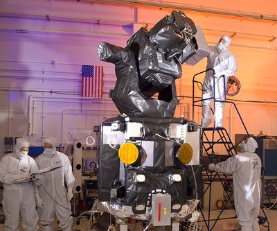
The Space Based Space Surveillance (SBSS) Pathfinder satellite, built by Boeing and Ball Aerospace, is scheduled for launch this summer on a Minotaur 4 rocket from Vandenberg Air Force Base into polar orbit. From that orbit it will look out towards geosynchronous orbit (GEO), with the capability of scanning the entire GEO belt once a day and transmitting those observations back to Earth.
“SBSS is going to provide a lot of capability to the Air Force,” said Col. James “J.R.” Jordon, SBSS mission director and vice commander of the Air Force’s Space Superiority Systems Wing, during a briefing about SBSS at the National Space Symposium in Colorado Springs last month. “It’s going to provide 24/7 capability, increased timeliness, increased capacity. It is critical to have this asset in space to augment what we have on the ground today.”
SBSS will provide this capability with a 30-centimeter telescope, mounted on a two-axis gimbal and equipped with a 2.4-megapixel sensor. The gimbal gives the telescope a very wide field of view: 3π steradians, or three-quarters of the entire sky. All this is incorporated into a BCP-2000 spacecraft bus provided by Ball Aerospace, with a total mass of under 1,100 kilograms.
“What we’re delivering is a factor of three improvement in the probably of detecting threats and over a factor of three improvement in timeliness,” said Todd Citron, director of space superiority and special missions for Boeing, at the symposium briefing.
SBSS won’t be the first space-based sensor used to track objects in space. For several years the Space Surveillance Network (SSN) used the Midcourse Space Experiment (MSX) satellite, launched in the mid-1990s originally to test sensors for tracking ballistic missiles. Jordon, though, said that SBSS would be the only space-based sensor for the SSN. It will also be considerably better than the MSX: Citron said that SBSS will have over twice the sensitivity and ten times the capacity of “prior space-based sensors”.
The third “S” in SBSS is “System”, implying that the initial, or Block 10, satellite scheduled for launch this year will the first of several. While there are notional plans for a network of several similar satellites, there are few details about the follow-on system. “We’re going to do an open competition, and we’re working through the acquisition strategy right now,” Jordon said.
He did, though, make it clear that the Air Force was committed to a successor to this initial satellite, which has a mission life of five and a half years. “The Air Force is not going to let this system just fall off,” he said. “We need this capability in space, so we’re planning on doing a follow-on program” that will have spacecraft in orbit or ready to launch by the time the initial spacecraft reaches the end of its life.
The data that SBSS provides, though, is only as good as the ability to use it to identify potential “conjunctions” between objects and alert satellite operators so that they can take action, as the Cosmos-Iridium collision last year illustrated. (Even SBSS may not have been able to help provide observations, since it is designed primarily to look out towards GEO.) In the last year the Air Force has been taking steps to address those issues with the data currently provided by the SSN.
“All of our activity in [space] situational awareness is intended to go from where we have always been in maintaining a catalog of objects on orbit to realtime awareness of what is happening on orbit,” said Gen. Robert Kehler, commander of Air Force Space Command, in a speech at the National Space Symposium. “That is the way we are headed and we are having spectacular success there.”
Since last year’s collision the Joint Space Operations Center (JSpOC, pronounced “jay-spock”) has increased the number of conjunction analyses—using the data provided by the SSN to look for potential collisions between objects in orbit—by more than threefold, Kehler said, and now looks at all active satellites in orbit.
| “All of our activity in [space] situational awareness is intended to go from where we have always been in maintaining a catalog of objects on orbit to realtime awareness of what is happening on orbit,” said Gen. Kehler. |
At the time of the Cosmos-Iridium collision, available resources limited conjunction analyses to human spaceflight missions, critical US government spacecraft, and “as best we could, other satellites of interest,” said Maj. Gen. Susan Helms, director of plans and policy for US Strategic Command (STRATCOM) and a former NASA astronaut. “To this date, we still don’t have the capacity to manage all 20,000-plus objects” currently tracked, she said, but since the collision they have built up their conjunction analysis capability to examine 1,100 “maneuverable” objects against the full catalog.
Another change since the collision is the transition last December of what’s known as the Commercial and Foreign Entities (CFE) program STRATCOM. Originally a pilot program by Air Force Space Command to share space situational awareness data with organizations outside the US government, CFE is now a permanent program. Helms said that, as of last month, STRATCOM had 16 agreements, all with commercial entities, to share such data. Over the long term, she said, she hopes to “broaden the aperture” of those agreements by both increasing the number of organizations they share data with as well as the scopes of those agreements.
“The good news is that the US Air Force is moving forward with major initiatives to improve SSA,” said Joseph Sheehan, president of Analytical Graphics, Inc. (AGI), a company that provides software and services for SSA. The commercial sector, though, is also working to better share data among itself. The Space Data Association was formed last year by a number of satellite operators to exchange information about the location of their satellites, and recently selected AGI to operate their data center. Creating the center is a “huge step forward” for improving SSA, he said.
Even with the new data center, though, he said there’s an increasing need for cooperation among governments and commercial operators. “What this all boils down to across the board is a need for true collaboration among the space community,” Sheehan said. “SSA shouldn’t be a competitive mission, because when one country or operator faces a crisis, all of us are in jeopardy.”