The wizard war in orbit (part 3)SIGINT satellites go to warby Dwayne A. Day
|
| Fighting SAMs was a brutal business, and eventually the US military brought its top secret signals intelligence satellites into the war, using a strategic asset for tactical purposes. |
In December 1962, COMOR produced a detailed justification memo on the use of satellites to collect signals, comparing their capabilities and limitations to other collection methods, which at the time primarily consisted of the RB-47 Stratojet, RC-135 Rivet Joint, and other aircraft flying along the periphery of the Soviet Union and other countries, sometimes at great risk to their airmen. Satellites had advantages over aircraft for detecting signals. As the memo noted, “If the purpose of the satellite is unknown, it is not likely that target emitters will be shut down for security during the periods in which the collection attempt is being made. The shutting down of emitters is a more likely occurrence in the case of non-satellite reconnaissance operations.” But satellites also had their limitations, including reliability issues: whereas a satellite might be able to operate continuously for a week, and eventually many months, it could also break down suddenly, something that had happened to the second Agena SIGINT launch in 1962. Unlike an airplane, if the electronics failed, there was no way to fix them.
The COMOR document also stated overall satellite SIGINT collection goals, which included:
- Detect and determine the characteristics of new and unusual signals in the Sino-Soviet Bloc
- Determine the character of the antiballistic missile (ABM) system
- Determine location and characteristics of ICBM- and IRBM-associated radars
- Determine the characteristics and locations of guidance radars associated with SAM sites within the Sino-Soviet bloc
- Determine Radar Order of Battle (ROB) for electronic warfare/ground-control intercept emitters within the Sino-Soviet bloc
- Determine characteristics of electronic equipment associated with the Soviet space program
- Determine characteristics of submarine-launched missile telemetry
The National Reconnaissance Office had launched two Agena signals intelligence satellites in 1962 as part of Program 102, and two more in 1963 as part of Program 698BK (see part 1.) These satellites included payloads that could conduct some of these missions. But the longest that any of those satellites had lasted in orbit was ten days. Those four satellites had carried digital payloads that were primarily intended to provide data useful to strategic bomber crews who wanted to avoid Soviet radars, contributing to the ROB, a constantly changing map of types and locations of various hostile radars around the globe. The Agena SIGINT satellites were multi-purpose, and in addition to the ROB mission they also performed other duties such as detecting new signals.
Analysts were also interested in detailed recording of the signals themselves. The SIGINT Satellite Story, a declassified official history of the program, defined this as “the fine-grain characteristics of radars of the highest priority.” Such data could assist in developing countermeasures such as jamming techniques used by B-52 bomber crews penetrating Soviet airspace to nuke Moscow. When the overall Samos Subsystem F program was slightly scaled back in December 1961, a Group 2 analog payload had been eliminated along with an on-orbit programmer for the analog missions. Despite this small reduction in priority, analog missions remained important.
In 1963, the satellite program designation was changed from 698BK to Program 770. The first of the Program 770 wideband analog missions, designated Mission 7156, launched on February 27, 1964, atop a Thor Agena-D from Vandenberg Air Force Base in California. After jettisoning its payload fairing exposing the antennas on its front and upon reaching orbit, the spacecraft tilted down so that its antennas pointed toward the ground. Thereafter it used Earth’s gravity to keep it oriented in that direction, which ground controllers believed was stable. The first two Agena SIGINT satellites had gone into orbits inclined approximately 82 degrees to the Equator. But each successive launch had gone to a slightly higher orbit, and this satellite was placed into a 459-by-533-kilometer orbit that gave it a little more time over its targets compared to its predecessors. The spacecraft had a mission lifetime of 12 days. But erratic operation of the wideband AMIE helical-scan tape recorder (caused by tape “gunking” of the record heads) led to frequent loss of data from one or two of the four recording heads.
For reasons that are unclear, Mission 7156 had jumped ahead in the launch queue, flying before Mission 7155. This may have been due to a requirement to conduct the analog detailed technical analysis mission earlier rather than later. But although 7156 was not a digital mission emphasizing the Radar Order of Battle task, it did carry a new payload designated BIRD DOG, used to pinpoint the location of emitters. This particular payload was designated as BIRD DOG 2, and an indication of its importance was that it also received its own mission designation: 7212. BIRD DOG 2 lasted three days longer than the main payload.
| In March 1964, James Q. Reber, chairman of the Committee on Overhead Reconnaissance, reported that SIGINT operations were providing great results. |
BIRD DOG was designed to improve location accuracy of emitters. It was a version of an S-band system carried on the U-2 spyplane and used phase measurements to describe the angle-of-arrival of a signal. Strategic Air Command processed the BIRD DOG data and used it for planning routes for its bombers. Although how this data was translated into actual aircraft operations is still unknown, it undoubtedly contributed to a closer working relationship between the National Reconnaissance Office, which developed and operated the satellites, and the Strategic Air Command officers who used the data.
In March 1964, James Q. Reber, chairman of the Committee on Overhead Reconnaissance, reported that SIGINT operations were providing great results. “The data thus far collected from deep within the USSR has confirmed that the same equipments operationally deployed on the periphery are also noted throughout the interior,” Reber wrote. This was very important, Reber pointed out, for “knowledge of the location and operating characteristics of defensive radars employed is estimated to produce an attrition factor reduction of as much as 50 percent for penetration forces,” meaning that B-52s sent to attack Soviet targets had a higher chance of making it through the defenses. Reber also added that SIGINT information was being used to identify targets for photographic missions. “Since the USSR is increasingly aware of peripheral collection efforts, the SIGINT satellite program will enhance the probability of intercept of electronic systems now suspected of being deactivated because of, or beyond the intercept range of peripheral efforts,” Reber declared.
By 1964, the NRO had flown several dozen signals intelligence payloads under a variety of programs. These included the Naval Research Laboratory’s GRAB/DYNO satellites that had soon been succeeded by the more capable POPPY satellites, the large Agena SIGINT satellites, and an increasing number of AFTRACK payloads launched attached to other low Earth orbit spacecraft. The field of satellite SIGINT was maturing rapidly, and soon COMOR expanded its activities from not only picking individual targets for SIGINT satellites to investigate, but also to recommending the establishment of collection requirements for new systems. In August 1964, COMOR sent a recommendation of requirements to the United States Intelligence Board, which had the task of establishing requirements for new intelligence satellites. COMOR’s list of requirements included:
- General Search
- Radar Order of Battle
- Directed Coverage:
- ELINT
- COMINT
- Laser detection and recognition
POPPY was by then conducting the first of these missions, general search: finding entirely new types of emitters. The Agena SIGINT satellites were conducting the second and third missions. The AFTRACK payloads, flying on the backs of CORONA photo-reconnaissance satellites, were also conducting directed coverage missions at a faster turnaround time than the Agena satellites. There is as yet no indication that the laser detection and recognition mission was pursued during this period.
Whereas the AFTRACK payloads that flew attached to the back end of Agena spacecraft carrying photo-reconnaissance cameras were primarily intended to be quick responses to emerging Soviet radar capabilities, sometimes they were also used to test out new equipment. For instance, in January 1964 a Naval Research Laboratory POPPY signals intelligence satellite included a payload named HAYLOFT, which tested an AMIE recorder and a KW-26 encryptor for encrypting signals sent to the ground. This equipment could have been used on future Agena satellites, but the test was not in time to help Mission 7156’s gunky tape recorder.
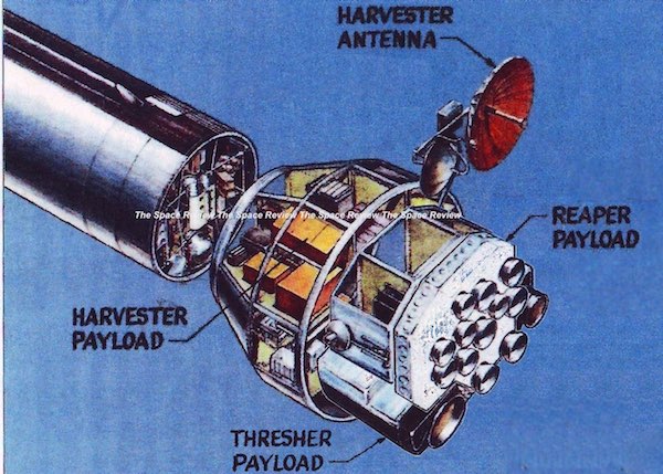
 MULTIGROUP 2 satellite on the launch pad in July 1967. This spacecraft included the SETTER 1B and DONKEY payloads. (credit: Peter Hunter) |
Better technology, better performance
On July 3, 1964, another Thor Agena-D carrying a Program 770 satellite launched from Vandenberg. Mission 7155 was a Group 2D payload. The spacecraft also included Mission 7211, the BIRD DOG 1 payload. The spacecraft operated nearly five days, less than half the time of its predecessor. But those five days still included multiple passes over the Soviet Union, gathering many radar signals.
On November 3, 1964, Mission 7157 launched atop a Thor Agena into orbit. This was a Group 3D payload listening in a different part of the frequency band than previous satellites. The satellite operated for four days. According to the official history, the location accuracy for the detected radars improved over previous missions. But the satellite’s BIRD DOG 3 payload failed. BIRD DOG 3 was equipped with an experimental inflatable antenna system that collapsed in orbit. It was supposed to enable BIRD DOG to intercept low frequencies. According to the official program history, “a powerful ground camera snapped a picture of this subsidiary payload in orbit and it was an ugly, wrinkled sight!” Although this account is included in the official program history, 1964 was rather early for good ground-based imaging of satellites in low Earth orbit, and no other details are available.
| Although there is no data on how the intelligence community responded to these increased lifetimes, the early satellites were primarily used to provide data that would be analyzed in the future. But longer-lived satellites offered the possibility of using some of their data in near-realtime. |
Program 770 Mission 7158 was launched on February 27, 1965, atop a Thor Agena from Vandenberg. It was a Group 1 analog configuration and covered a frequency band of 640 megahertz to 8.28 gigahertz. It also included Mission 7225, BIRD DOG-4. The spacecraft had solar arrays, which enabled it to operate for 51 days, far longer than any of its predecessors. Solar arrays had first been tested on Mission 7156 launched a year earlier, but battery problems on that mission negated their benefits.
Another Program 770 satellite, Mission 7160, launched on February 9, 1966. It was a Group 3D payload. It also carried a 100-kilohertz bandwidth Leach magnetic tape recorder. (A similar recorder was carried on 7157 for analog-signal detection.) The spacecraft conducted 736 readouts of digital and 429 readouts of analog data during the seven-month satellite lifetime. This resulted in several thousand updates to the Radar Order of Battle for the Defense Intelligence Agency and Strategic Air Command. Unfortunately, the analog data suffered from bandwidth restrictions that had also occurred during Mission 7157, resulting in little technical intelligence.
The Mission 7160 spacecraft also carried a new auxiliary payload manufactured by LTV E-Systems, a follow-on to BIRD DOG known as SETTER. SETTER had much higher location accuracy and also revealed something about the spacecraft: it was yawing in response to interaction with the Earth’s magnetic field. Ed Stillman of Lockheed discovered this phenomenon. His coworker Duane Scott calculated the forces and came up with a solution by placing magnets on the Agena’s structure to counteract the natural forces. This equipment was used to damp out unwanted oscillations on the later missions.
Mission 7160 had far exceeded the lifetime of its predecessor and indicated the possibility that Agena SIGINT satellites launched approximately six months apart could provide continuous coverage. Although there is no data on how the intelligence community responded to these increased lifetimes, the early satellites were primarily used to provide data that would be analyzed in the future. But longer-lived satellites offered the possibility of using some of their data in near-realtime. This undoubtedly led to evaluations of how the collected data could support ongoing military operations.
A multitude of designations
The designations and names of these American signals intelligence satellites were changed several times during the early 1960s, making it difficult to keep track of them. The changes appear to primarily have been the result of bureaucratic reshuffling, although occasionally they were due to changes in the security system in which the programs operated. The signals intelligence satellite program had originally been named Samos Subsystem F, renamed Program 102, and then renamed Program 698BK, a designation that encompassed several other satellite programs as well. Since June 1962 these projects had been operating under the security designation of Secret Special Handling. But most other National Reconnaissance Office projects, such as the Naval Research Lab’s POPPY satellite, were part of the more secretive BYEMAN compartmented security system. In November 1963, Program 698BK was also brought into the BYEMAN program and the program number was changed to 770.
The Air Force “Program Number” system was a means by which people working on classified programs could still refer to them in an unclassified manner. For example, if an Air Force officer had to travel to a launch site or a contractor, his travel expenses could be charged to the unclassified program number and processed by people who did not have access to classified information. This was also the case for launch site personnel who were not cleared to know the identity of the payload, but did have to know certain details about the launch. These numbers were not supposed to be widely shared, because they could still provide some information to foreign intelligence services or the press. For instance, knowing that a person had traveled to Vandenberg Air Force Base on Program 206 business just before a satellite launched into polar orbit, or regularly visited a city like Rochester, New York, where optics manufacturer Eastman Kodak was located, could indicate that Program 206 was a photo-reconnaissance satellite.
But further complicating and obscuring understanding this nomenclature is the fact that declassified histories seem to use “Program” and “Project” interchangeably, and sometimes simply used the shorthand “P.” So the “P-11” satellites really were officially designated “Program 11,” but are not referred to by that name in historical documents. The Agena spacecraft also had their own serial numbers, and often historical documents refer to the Agena number and not the Mission number or the Program (or Project) number.
The February 9, 1966, launch of Mission 7160 was the ninth Agena signals intelligence satellite. It also appears to have been the last of the direct descendants of the Samos Subsystem F satellites. The original plan for Subsystem F was for four F-2 and four F-3 satellites, not including the first Agena launch that had carried a leftover F-1 satellite payload. In 1962 the procurement of F-3 satellites was reduced from four to three. But the design of the satellites was significantly changed starting with the tenth launch, implying that the National Reconnaissance Office did in fact build four F-3 satellites, albeit after discontinuing the F-3 designation.
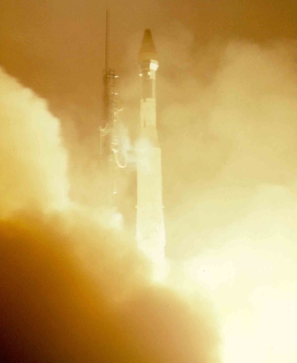 Launch of a STRAWMAN signals intelligence satellite. Note the larger payload fairing which had been increased to accommodate the large antennas carried on these spacecraft. (credit: Peter Hunter) |
The debut of MULTIGROUP
One limitation of the signals intelligence satellites flown in the early 1960s was that they were designed long in advance to intercept specific frequencies. Antenna configurations were difficult to change without major redesign and testing. These limitations led the program leaders to begin development of a new satellite called MULTIGROUP. MULTIGROUP would have eight possible frequency bands, each with a matching antenna. Any four bands could fly at a time with minimal turnaround time. At least that was the plan—implementation proved to be harder to achieve than expected.
Director of the National Reconnaissance Office Brockway McMillan approved development of MULTIGROUP in November 1963, and in April 1964 he approved the first launch for exactly two years later, with three additional launches in fiscal 1967. But in September 1966 the total number of MULTIGROUP satellites was scaled back from four to only three.
Like the payloads for the previous Agena signals intelligence satellites all the way back to the earliest days of Samos Subsystem F, the MULTIGROUP payload was built by Airborne Instruments Laboratory of Deer Park, New York. SETTER, which had flown on the previous mission, was built by LTV’s E-Systems at Dallas, Texas, which had also built the BIRD DOG payloads.
MUTIGROUP had improved locational detection accuracy compared to its predecessors and was capable of determining location within 20 miles (32 kilometers) at frequencies as low as 59 megahertz. SETTER, which was specifically designed for locating targets, provided emitter location accuracy of 5 miles (8 kilometers), but could not operate at frequencies below 2 gigahertz because that would require a large antenna like the failed BIRD DOG-3 inflatable antenna. MULTIGROUP used single spiral antennas that divided the target area into sectors and used single-pulse phase comparisons to achieve geolocation. Improved versions of the payloads shared a new solid-state core memory for the digital data and an improved tape recorder called a data storage unit. MULTIGROUP and SETTER operated independently, requiring duplication of ground processing their data.
| The satellite already had three other outboard antennas, so packing a fourth antenna into that space required careful planning—sort of like loading up a pack mule. Engineers came up with an unusual solution, a bulge in the side of the spacecraft’s payload fairing to fit the extra antenna for DONKEY. |
Although the first Program 770 MULTIGROUP mission, number 7161, had been planned for April 1966, technical problems delayed it until the end of the year. This was not the first time that the signals intelligence satellite program had run into development delays. In July 1965, Brigadier General John L. Martin Jr., director of Special Projects at Los Angeles Air Force Base in El Segundo, California, became concerned about performing a systems test of the spacecraft at Lockheed’s facility in Sunnyvale and then disassembling and shipping it to Vandenberg where it had to be tested again. This not only created excessive wear and tear on the system, but Martin was also concerned that it encouraged the contractor to ship the payload and Agena to Vandenberg with “open items” still to be solved or fixed at the launch site. Martin ordered development of a new processing method that would process the payload and vehicle as a unit and send them directly to the pad, without any remaining problems. The process was named FASTBALL and the goal was 17 days from receipt of the payload at Vandenberg to launch.
The first test of this was in December 1966. Agena 2731 with the MULTIGROUP 1 payload arrived at Vandenberg and 25 working days later it was launched on December 28, 1966. The launch used a new Thor rocket equipped with Castor solid motors. MULTIGROUP 1 operated for over five months in orbit, not quite as long as its predecessor, but clearly establishing that the Agena SIGINT satellites could last for nearly half a year.
DONKEY
In summer 1964, Colonel John Copley, who had previously worked on the National Reconnaissance Office’s signals intelligence satellites at Los Angeles Air Force Base, was assigned to the Manned Orbiting Laboratory program at Air Force Headquarters. Copley was given the task of determining if there were signals intelligence applications for MOL, and in February 1965 he apparently focused on a specific mission. One idea—it is unclear if Copley came up with it or merely evaluated the proposal—was for a communications intelligence (“COMINT”) payload to intercept signals from a Soviet microwave communications system serving both civil and military users. The identity of the target system remains classified, but it apparently consisted of a network of transmitters throughout the Soviet Union. Copley determined that intercepting the transmitters’ narrow main beams would be difficult, but that collecting from their sidelobes, which radiated out at much lower power from a transmitter’s sides like the feathers on a peacock, would increase intercept times while a satellite was overhead. In the best case, it could gather up enough information to determine what was being transmitted over the network, at least while the MOL was overhead.
Copley proposed that this signals intelligence collector should be included on MOL. It would use a six-foot (two-meter) diameter parabolic “wrapped rib” antenna that would unfold from the side of the big cylindrical MOL. Unlike an umbrella-type dish, the antenna wrapped flexible ribs and the mesh antenna strung between them around a central spoke, enabling a larger diameter antenna to be packed in a smaller volume.
E-Systems in Garland, Texas, and EDL-Sylvania developed a test system. An Air Force helicopter flew a payload in an intercept pattern through the main beam and sidelobes of a microwave antenna at the E-Systems facility outside Dallas. EDL analysts examined the collected data and made recommendations for a mission. The payload activities were handled within the BYEMAN security control system under a unique management arrangement.
Sometime in 1965, with the MOL getting increasingly complicated, MOL program managers decided to eliminate the communications intelligence payload from the spacecraft. Although the details are somewhat murky, in November 1965, the SIGINT Working Group of the Committee on Overhead Reconnaissance, which established targets and prioritization requirements for US signals intelligence satellites, determined that the information transferred over the Soviet communications network had “high intelligence value.” In a document, the group declared that a system was required “to obtain sufficient technical data concerning the location, antenna patterns, and modulation of the [deleted] system to permit valid consideration of [a] follow-on collection system.” The group also indicated that this data could be useful for a planned geosynchronous signals intelligence collection system whose name was deleted from the document, but was almost certainly the CANYON satellite then being built by Lockheed and eventually launched in 1968.
With the payload no longer part of the MOL program, the National Reconnaissance Office officials soon transferred the project to the program office in Los Angeles that operated the NRO’s growing stable of SIGINT satellites. It is unclear when or why the payload was named DONKEY, although it clearly had this code-name by early 1966. Program managers and engineers began evaluating how to fly DONKEY. Apparently they initially considered putting the payload on a small dorm refrigerator-sized P-11 satellite of the type routinely pushed off the back of Agena spacecraft hosting CORONA or GAMBIT photo-reconnaissance payloads. (The P-11 satellites will be discussed in part 4 of this series.) But for unknown reasons the P-11 proved unsuitable.
Next, Copley and his colleagues evaluated the possibility of mounting the payload on the rear of an Agena-based MULTIGROUP satellite. Starting in 1960 the Los Angeles program office had mounted a number of signals detection payloads on the aft rack of the Agena, as part of the AFTRACK program (see part 2.) AFTRACK was discontinued by 1966, but DONKEY was designated as the last AFTRACK payload.
The MULTIGROUP satellite would point nose down at the Earth with its nest of antennas at the front and three solar panels sticking out at the back. But the aft rack of the MULTIGROUP Agena proved to be a poor location for the large antenna, because it would interfere with the solar panels that would be deployed in orbit. Engineers soon determined that the best location was the front of the MULTIGROUP satellite. The front of the Agena presented problems because MULTIGROUP was crammed with payloads. The satellite already had three other outboard antennas, so packing a fourth antenna into that space required careful planning—sort of like loading up a pack mule. Engineers came up with an unusual solution, a bulge in the side of the spacecraft’s payload fairing to fit the extra antenna for DONKEY.
On July 24, 1967, the second MULTIGROUP satellite was launched carrying the DONKEY payload. After the Agena placed it in orbit and the payload fairing was jettisoned, the Agena pitched nose down and MULTIGROUP began deploying its antennas. The mission consisted of several MULTIGROUP 2 payloads looking at a range of frequency bands, plus DONKEY, plus the SETTER location finding payload.
DONKEY ran into problems almost immediately when its antenna pointing mechanism failed, preventing it from performing the sidelobe collection mission. It could detect but not gather signals for long enough to provide useful intelligence about them. DONKEY was still able to map emitter locations in the Soviet Union, leading to development of a grid that indicated a large majority of the emitters throughout the Soviet landmass. That data proved valuable for later collection activities that remain classified.
DONKEY also made it possible to map communications facilities located at Sary Shagan, the sprawling Soviet radar and anti-ballistic missile testing facility on the shore of Lake Balkhash in Kazakhstan. Sary Shagan’s radars tracked ballistic missiles as well as satellites, but they also had to communicate with other facilities and Moscow, and DONKEY helped figure out how the place was connected. Although how this information was ultimately used remains classified, an obvious objective would have been to eventually develop the ability to intercept signals from Sary Shagan with the goal of gathering performance data on Soviet ABM systems. Starting in the mid-1960s the CIA had initiated an unmanned drone program named AQUILINE with a plan to fly the aircraft along the communications transmission path for Sary Shagan. But AQUILINE was ultimately canceled due to cost.
DONKEY had an independent downlink and operated for 182 days, 30 days longer than the other MULTIGROUP payloads due to a failure of their data link transmitter. Although nobody knew it at the time, DONKEY turned out to be the only operational intelligence legacy of the Manned Orbiting Laboratory program. MOL was canceled two years after DONKEY flew, and none of its other hardware made it into space.
MULTIGROUP 1 had launched at the end of 1966. MULTIGROUP 2, with SETTER 1B and DONKEY, launched in July 1967. The satellites had established a regular cadence of launches approximately every six months. Program 770 had clearly evolved into a system capable of providing routine, regular, and reliable signals intelligence.