Why the US should notify the public of all satellite reentriesby Charles Phillips
|
| 90020 transmitted on a frequency known to be used by the US government’s Satellite Data System (SDS) constellation. The optical observer community knows what orbits are used by various satellite systems and 90020 was in the right orbit to be an SDS. |
However, somewhere in the world, someone might have seen a satellite reenter and wondered what it was. The good news in this case is that those people would have been sailing in the South Pacific, far from land. But if the US knew that the satellite was about to reenter, shouldn’t our country have notified someone? Unannounced reentries have happened before and will happen again, but many of them could be announced with no loss. Each reentry incurs risk, which the US government has decided that it would accept. But is there a reason to accept any risk in these cases?
What was that satellite?
As someone who finds it fascinating to watch satellites and what they are doing, I have been following a number of satellites that have very low perigees and so are going to reenter in the “near” future, especially those that are not in the default official satellite catalog. Catalogued satellites will have reentry warnings distributed by the Aerospace Corporation, but satellites like the example above reenter with no prior notice. People that are under the path of those satellites may have a satellite reenter above them. In 2016, one of them, called 90020, had a perigee that was below 100 kilometers and later in the year disappeared from the list of satellites that the amateur astronomer community has been tracking. It had reentered the atmosphere.
I have discussed the situation of the unknown satellites reentering in earlier stories, and this is another example. An earlier story about satellites with low perigees has some needed background (see “Acknowledging some overlooked satellites”, The Space Review, June 12, 2017).
But first, what was 90020 and why do we refer to it by that number? Is there any reason to follow satellites like this and wonder about where they reenter and who is below its reentry point? What can we reasonably assume about this object? This object must have been large since it was relatively easy to observe: it was seen by two observer networks. Most satellites in orbit around the Earth have a satellite number and an “international designator” that is assigned by the US Air Force, who also normally distributes their orbital parameters. But for a number of these satellites the orbital parameters are not released and the satellites are given a number of generic names. However, astronomers can still track them and they assign numbers to the ones that do not match orbits released by the US Air Force. The optical community tracked this satellite and named it 90020. The amateur radio community listens to many satellites and they know what frequencies various satellites use to communicate with their ground teams. 90020 transmitted on a frequency known to be used by the US government’s Satellite Data System (SDS) constellation. The optical observer community knows what orbits are used by various satellite systems and 90020 was in the right orbit to be an SDS.
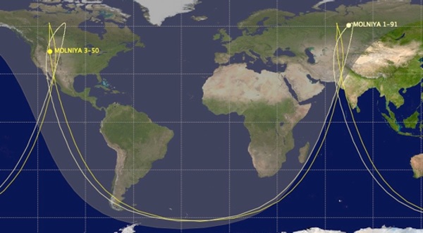
While it was operational, this satellite was in an orbit that had a very low perigee of about 300 kilometers, a very high apogee of about 40,000 kilometers, and a high inclination of about 61.5 degrees. With that orbit, the satellite appears to stay within a small part of the sky for quite a while at apogee, which makes it possible to point an antenna in that direction for communication without having to move the antenna. Alternatively, a satellite in that orbit could stare at the ground below. It is similar to having a geosynchronous satellite but one that is over the polar regions, so it could observe the polar regions or communicate with stations in those regions. This is often called a “Molniya” orbit after the first Soviet (now Russian) satellites that used it. This ground trace shows the orbital paths of two Molniya satellites.
 |
Apogee is in the Northern Hemisphere and you can see that this satellite is not going to reenter over an inhabited area. The earliest SDS satellites were 630 kilograms and the second version was 2,335 kilograms, and so significant components could be expected to survive reentry. It is possible that people below the reentry point could be alarmed or possibly even injured. The US government alerts the community about many impending reentries but does not for these “off the books” satellites.
Orbital terminology
A common format to exchange orbital parameters is the now-ancient Two Line Element set, or TLE. These were created a long time ago when we entered information into computers in Hollerith cards, each with 80 characters encoded. I shudder to think of how many of those I typed. Today the “default” official world satellite catalog is maintained by the US Air Force and they do an adequate (let’s be generous) job, as they provide TLEs for most satellites. But for some satellites that are considered sensitive for various reasons, the TLEs are left blank.
| From looking at the SDS satellites that were flown, 90020 almost certainly was object 20167, USA 40, which was launched by STS-28—a Space Shuttle flight in 1989. |
As I said in a previous article about applying common sense to the default official satellite catalog, our friend 90020 has a cataloged counterpart, but the orbit was not released (see “Time for common sense with the satellite catalog”, The Space Review, April 10, 2017). For the cataloged counterpart, the US Air Force has not released the mission.
In the case of 90020, it was discovered by an amateur astronomer, Peter Birtwhistle, in February 2004 and its radio transmissions were recorded as early as 2006. The amateur communities tracked it for many years. While it was operational the ground controllers kept it in an operational orbit, but at some point it was retired and it probably ran out of fuel. At that point, the orbit began to drift and also began to take the satellite nearer to atmospheric reentry. Had this been an object in the satellite catalog, the Aerospace Corporation would have eventually started to include it in the list of pending reentries.
From looking at the SDS satellites that were flown, 90020 almost certainly was object 20167, USA 40, which was launched by STS-28—a Space Shuttle flight in 1989. The next SDS satellite that was launched went to geosynchronous orbit, so it would not have been in that inclination, and the third one was launched in December 1992. So there were other satellites that could have been 90020—none of which are listed as having reentered in the satellite catalog.
Let’s tell people about satellite reentries
After 90020 retired, and as it approached reentry, its orbital parameters could have been released; the TLE for 20167 (or whichever one it was) could have been shown. The satellite in the catalog that was probably 90020 also might never be officially declared as decayed, as those off-the-books satellites are frequently never officially updated. The satellite was certainly retired before it reentered and the US Air Force could have just continued to identify it as USA 40 or whatever it was; there would be no reason to release any information about its mission. But at least then it would have been included on routine warnings of reentering satellites, joininh the ones in the official warnings. And the official satellite catalog would be that much closer to being correct.
For this satellite, few people were in a place to even see the reentry, but in a case reported by a member of the optical astronomer community, Ted Molczan, an off-the-books satellite reentered over Spain without warning and could have caused damage on the ground. (See “Re-Entry Sightings and Debris Recovery of 2008-010B Spain - 2015 November 03 UTC” Ted Molczan, Journal of Space Safety Engineering, Vol 2, Number 2, December 2015.) Satellites whose orbital information are left out of the satellite catalog have reentered and will continue to reenter.
| The US government can continue to conceal the missions of important satellites but it is being irresponsible in concealing the orbits of satellites in this situation. We are better than that. |
Even though the official reentry warnings did not mention this satellite, some of us here were watching and are continuing to watch other satellites. We also made some futile attempts to contact people in the South Pacific, but fortunately the risk has always been minimal.
Predicting satellite reentries
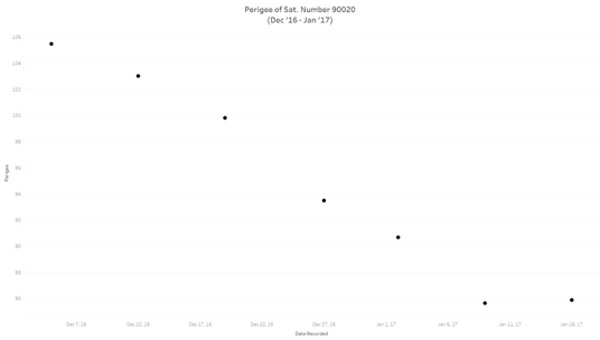
One fascinating puzzle is predicting when these satellites might reenter. Over time, the low perigee will cause the apogee to come down and make the satellite less useful. However, with satellites like this, the eccentricity is perturbed (changed) due to solar and lunar effects, and this causes the perigee to rise and fall. It is unusual to find satellites where the perigee will ever rise. These satellites have a very high velocity relative to the atmosphere at perigee and so tend to build up a “bow wave” of air that can significantly slow them down even when they are above 200 kilometers. The fact that 90020 survived this low perigee indicates that it was fairly dense. The plot below shows the final predicted perigees of 90020 and it is clear that there is a trend - the perigee drops rapidly towards the end of its life.
 |
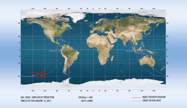
Of course, these satellites will reenter near perigee, but that point moves around the Southern Hemisphere on each orbit, so the trick is to determine which perigee it will not be able to survive. Even for satellites in circular orbits, they are considered to be decayed when their perigee dips to 80 kilometers. Joseph Remis has software and experience that allow him to produce a fairly accurate decay point. The following map shows where 90020 probably reentered the atmosphere, in a very unpopulated area.
 |
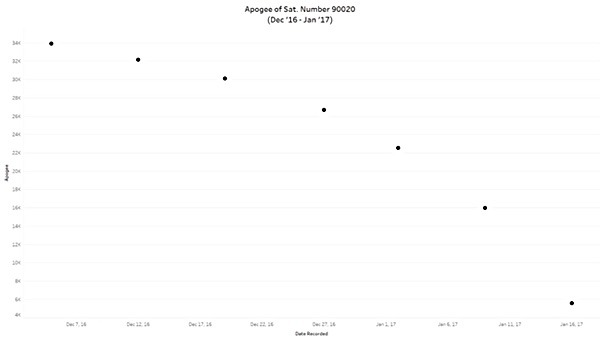
It is also instructional to look at the plot of apogee and see how quickly it changed. Every time the satellite went through perigee it lost a lot of energy and so had a lower apogee.
 |
By the time that 90020 was close to reentry its ground trace looked far more like that of a satellite in a circular orbit, but the perigee remained in the Southern Hemisphere.
The TLEs of these satellites are not updated as often as the cataloged ones and so reentry predictions are done with less information than for many objects. If anyone with better information (like the people who owned the satellite) would like to add a comment below and correct us, please feel free!
Conclusion and postscript
In this case no one was threatened by this reentry, but this is not the only satellite in this situation. The US government can continue to conceal the missions of important satellites but it is being irresponsible in concealing the orbits of satellites in this situation. We are better than that.
Doing this analysis is a lot of fun but it is amazing to think of how it works. A retired astronomer, Greg Roberts, in South Africa who is a well-known amateur satellite tracker contributed most of the orbital information (the TLEs) and shared his recorded radio information, the amateur optical observer community was the source of two additional TLEs. Joseph Remis, who predicts many reentries, in France used that information to get an approximate entry time and location. He used both the TLEs from Roberts and from the amateur astronomer community separately and mixed, to get as accurate a prediction as possible. Brian Chambers, an amazingly talented programmer and data analyst in Houston, wrote some software and used it to generate the plot of the perigee and apogee. This article required quite a few electrons to cross many kilometers. Fortunately these people happily contributed their expertise. Much of the amateur optical observing community and the amateur radio community can be difficult communities to work with! We plan to continue looking at reentries of these satellites that no one else is providing information about.