Letter: The problems with tactical IR satellitesby Ryan Caron
|
| A month ago south Lebanon wasn’t a hotspot: the region had seen nearly six years of relative peace. If we had tactical satellites, would we have had considered coverage of that region important enough to deploy a constellation? Maybe, maybe not. |
Probably not even then. With five satellites dedicated just to that hot spot, you have only IR imagery about 2.7 percent of the time (coverage is in part a function of the hot spot’s latitude). That’s less than two minutes of coverage every hour. If one was using only a single satellite you would have coverage 0.5 percent of the time: a five hour gap between those short coverage windows. These numbers are based on a circular 500 kilometer orbit, a reference common in tactical satellite literature.
This is hardly usable for tactical use, where operations last minutes, not hours. Events on the ground can’t be scheduled around satellite availability. Lt. Col. Tomme’s more elaborate report, “The Strategic Nature of the Tactical Satellite”, explains in great detail how these coverage numbers are calculated and optimized. The Air Force has thought long and hard how to accomplish this—I’d take their word on it.
In comparison, a signal intelligence constellation would be providing coverage of the region 27.8 percent of the time. This is because such a satellite can gather radio signals from horizon-to-horizon, and is not constrained to the narrow field of view of imaging satellites. Unfortunately, signals intelligence is of limited utility in the asymmetric warfare that many military operations face today. Imagery is most prized info for asymmetric warfare, and unfortunately satellites are not well suited to this task. (High altitude UAVs such as the Global Hawk, which can loiter over an idea, are much more ideal for these applications.)
Third, the article outlines the requirements for a tactical IR satellite:
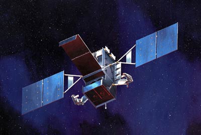
An operationally responsive tactical IR satellite system would have to be both affordable and based on proven and reliable technology… To make the program affordable it would have to be designed to use already existing bus and power supply systems and probably also an in-service communications architecture.
A pair of STSS satellites is being launched in 2008 despite being mothballed from the now-defunct SBIRS-Low program. They are to provide a testbed for the Missile Defense Agency to explore IR missile tracking. They certainly fit the bill for existing technology, but their overhaul has been less than affordable (due to, amongst other things, significant wiring degradation). These sensors fall woefully short of what is required to be operationally useful, but new sensors are expensive and unproven. Northrop Grumman also had to upgrade the power busses on these satellites to provide more power—even now the satellites can only be operating a small fraction of the time.
| Every infrared satellite program for over a decade, from “Brilliant Eyes” to SBIRS, has suffered significant delays and cost overruns. Some have been management blunders, while others have been technical in nature. |
Using existing communications systems sounds great, except earlier in the article Dinerman stated the “troops on the ground need information they can use in a timely and easily understood format.” The communications system to provide near-real-time imagery to a soldier in the field on a laptop or PDA simply doesn’t exist yet. The DoD wants such a capability very badly though, that’s why the Pentagon is building the Transformational Satellite Communications program. The backbone of the system, however, won’t be available until 2013 (and since it requires a lot of new technology delays are to be expected).
There is no in-service communications architecture available to the military that can do what Mr. Dinerman asking for. Indeed, a great majority of the DoD’s bandwidth-hungry operations are being served on commercial satellites, which certainly don’t have the capability yet either.
Fourth, Dinerman loathes the current budget environment:
Most important of all, the funding stream—no matter how much or how little—would have to be predictable so that the contractors would have the incentive to plan for the long term. This would be the most difficult part of the program since it would mean asking Congress to give up part of its power over the annual budget cycle.
Congress is demanding more control over space related appropriations, not less. Every infrared satellite program for over a decade, from “Brilliant Eyes” to SBIRS, has suffered significant delays and cost overruns. Some have been management blunders, while others have been technical in nature. When space programs such as NPOESS have violated the have Nunn-Mccurdy amendment due to cost growths of over 25 percent, Congress should be demanding more control over space-related appropriations. Indeed, even after NPOESS, neither the DoD as a whole nor the individual managers of these programs have proven themselves fiscally responsible. The damage that could be caused by less congressional oversight and control could be catastrophic.
Fifth, Dinerman recommends initial satellites starting with supposedly minimal requirements:
Another way to keep the program affordable would be to keep the early requirements to a minimum. The first versions should be strictly for ground force use only, with perhaps some applications for Marine Corps amphibious warfare requirements. Only after the system has proven itself should the program be allowed to move on to develop air-to-ground sensor-to-shooter loops.
Unfortunately “ground-use-only,” as used in the context of this article, is not less challenging than other applications. You still need satellites with sensors better than those that currently exist, a large constellation to provide sufficient coverage, and a non-existent communications network to quickly get the information to the troops that need it. The sensor-to-shooter loop is actually a mild extension beyond those requirements, mainly focusing on the ground-based segment of the system and not the satellites themselves. For the record, infrared is not good for amphibious and naval warfare, with most guidance systems for those applications using microwave instead.
Lastly, Dinerman claims how the system could be quite modest:
Ultimately a constellation of a dozen or so spacecraft in orbit, backed up by a similar number on the ground, would be ideal for the early versions of the full system. The ground segments will have to be as simple and as inexpensive as possible since it will need to be deployed with more than fifty Army and Marine brigade-sized units as well as with higher headquarters.
A dozen satellites, covering a single hot spot, would provide two minutes of coverage every half hour or so. This represents coverage roughly seven percent of the time. This is not nearly enough for tactical use, and one would assume that this small constellation would have to be covering multiple hot spots. In that case the coverage would only get worse.