Radar love: the tortured history of American space radar programsby Dwayne A. Day
|
| Satellite radar imaging is among the most classified activities conducted by the US intelligence community. The NRO will not even acknowledge the “fact of” the existence of such a capability. However, it is no secret that space radar is possible. |
The possibility of using radar from space was first discussed in the US Air Force during the Eisenhower administration. However, President Eisenhower placed very strict controls on satellite intelligence collection and at first insisted on personally approving every photographic satellite intelligence mission that the United States conducted. In this environment, the Air Force space leadership determined that radar transmissions from a satellite might be too provocative for a president already concerned about passively taking pictures and collecting electronic transmissions, and so they did not start the program at that time.
Although details remain sketchy, it appears as if an experimental radar satellite program was started during the Kennedy administration. This program, known as Quill, produced three satellites: two flight models and a test model. One satellite was launched in 1964. It used a radar that was probably built by Raytheon to take images of the ground which were stored on magnetic tape. Quill used the same recovery system as the Corona reconnaissance satellite, returning the magnetic tape to Earth in a recoverable capsule that was caught in mid-air by an aircraft.
According to someone who talked to Quill’s program manager, as well as another researcher who talked to a former senior intelligence official, the flight and the mission were successful, but the program was not continued. It is easy to speculate why. The satellite’s relatively low power and early technology undoubtedly limited its capabilities, particularly the size of objects it could spot. Quill could probably not spot anything smaller than a naval vessel. In addition, the data retrieval technique meant that information was not processed until long after it had been collected. The intelligence value was therefore probably too limited to justify further efforts.
By the early 1970s, the US Navy was considering a program known as Clipper Bow (i.e. the bow of a clipper ship). Clipper Bow was intended to detect ships at sea so the information could be transmitted to naval vessels, a technique employed by the Soviet Union with their Radar Ocean Reconnaissance Satellite (RORSAT). But Clipper Bow was soon canceled, apparently for cost and utility reasons.
From sea to ground to air
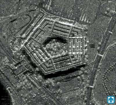
By the mid-1970s a new proposal emerged for a radar imaging satellite. Although details are scarce, this was apparently a controversial battle within the intelligence community. At the time, CIA officials wanted to add a radar capability to their new KH-11 real-time reconnaissance satellite. Department of Defense officials, though, wanted a dedicated radar satellite. Eventually the Air Force component of the NRO obtained approval to start a new program to develop a radar imaging satellite called Indigo. The name of this program was later changed to Lacrosse (apparently spelled “Lacros” in official documents) and then to Onyx.
In 1988 the Space Shuttle launched the first Onyx radar satellite (although a press leak referred to the satellite by its earlier name, Lacrosse and the program might still have had this name at the time.) More satellites were launched in 1991, 1997, 2000, and 2005. In 1998 the NRO even released images of one of these satellites under construction. The satellite is a large rectangular frame to which are attached numerous electronics boxes covered in gold-colored kapton insulating foil. According to amateur astronomers who have observed the actual spacecraft in orbit, the satellite has a large dish and two large solar panels sticking off the main body.
The satellite’s average radar resolution was reported to be about one meter, probably in the standard “pushbroom” mode where the radar essentially looks straight down and takes a continuous image, like a push broom being pushed across a floor. However, synthetic aperture radars have a mode called “spotlighting” whereby they spend several seconds taking repeated images of the same small area to improve resolution. By taking images for up to 17 seconds, Onyx reportedly could obtain a resolution of about 0.3 meters for a small area. Onyx remains the only operational American radar satellite system.
Articles by independent analysts contained some inaccurate speculation about radar satellites during this period. In 1977, NASA launched a radar satellite known as Seasat and used to observe the oceans. Seasat failed early in its mission, and there has long been speculation that the satellite had successfully detected American submarines at sea and this was so alarming that it prompted the Navy and/or the intelligence community to demand that the satellite be shut off. However, this story seems highly unlikely. If the satellite had been so successful, it seems more likely that the military and intelligence communities would have wanted it to continue in order to gather more data. At the very least, they would have wanted to try and track Soviet submarines. They could have easily classified the data while keeping the satellite in operation. There has been enough information released on Seasat’s failure to make it clear that a simple malfunction, and not a government conspiracy, was the real problem.
| By taking images for up to 17 seconds, Onyx reportedly could obtain a resolution of about 0.3 meters for a small area. It remains the only operational American radar satellite system. |
Another claim, originally made by the late British writer Anthony Kenden, was that in January 1982 the US tested an experimental radar satellite named Indigo. However, it is now clear that this launch was actually a modified photoreconnaissance satellite, part of a program called Higher Boy, and not a radar satellite. Indigo was in fact the name for the initial program to develop a radar satellite, but no actual spacecraft flew under the Indigo name. However, it seems unlikely that the NRO would have committed to a major new program without at least conducting some experimental tests first. Whether these were space-based, airborne, or simply conducted in a laboratory is unknown.
By the early 1980s, the Air Force was interested in a new project then designated Space Based Radar, or SBR. This was a project championed by Air Force Space Command, not the Air Force office that was part of the NRO. The purpose of Space Based Radar was to detect aircraft in flight. The justification was that such a satellite could act as a kind of space-based airborne warning and control, or AWACS, system, detecting Soviet bombers and tactical aircraft in flight long before they could be spotted by ground-based radars in Europe and elsewhere.
Throughout the 1980s, various Air Force generals declared that Space Based Radar was their highest priority new program. Despite this constant endorsement, the proposal was never adopted by the Air Force leadership or the Secretary of Defense for actual development. When the Cold War ended, the fundamental justification for the program evaporated and Space Based Radar was dead.
Discoverer II, Space Based Radar (again), and FIA
By 1998 a new satellite radar project emerged. The Defense Advanced Research Projects Agency (DARPA) proposed a project known as Starlite. This proposal actually broke a gentlemen’s agreement that DARPA would not intrude on the National Reconnaissance Office’s satellite intelligence turf by building experimental intelligence collection spacecraft. Eventually both the National Reconnaissance Office and the Air Force were included in what became a joint program soon designated as Space Based Radar.
Although the program shared the same name as the late 1980s radar program, it had a different focus. Instead of detecting aircraft, the target of this new satellite system was ground vehicles. During the Persian Gulf War in 1991 the Air Force had pressed into service a prototype aircraft system known as the Joint Surveillance Target Attack Radar System, or JSTARS. JSTARS was a large synthetic aperture radar mounted on a modified C-135 aircraft. JSTARS was a refined version of traditional synthetic aperture radar. JSTARS looked for the strong radar returns from metallic objects on the battlefield, which were most likely vehicles. JSTARS also had a capability known as moving target indicator, which tracked moving vehicles. But because it was a large aircraft, JSTARS was limited in where it could go. Even if the United States controlled the airspace, Air Force commanders were reluctant to take JSTARS too far behind enemy lines because of its vulnerability to missiles and aircraft. In addition, JSTARS was limited by the curvature of the Earth and any terrain such as mountains that could block its signal from reaching farther distances.
The new Space Based Radar would take JSTARS into orbit. The initial joint plan was for two experimental satellites as part of a program known as Discoverer II. But the Discoverer II program languished for years for reasons that are complex and also somewhat murky. At least part of the problem was high cost and poor management. But the NRO had also never been fond of the project and there have been rumors that the intelligence organization’s leadership fought Discoverer II at every opportunity. By early this decade the NRO withdrew from Discoverer II and the joint project was canceled.
Around the same time that Starlite had started, the NRO had also signed a contract with Boeing to develop the Future Imagery Architecture, or FIA. FIA was to involve a constellation of both photographic imaging and radar satellites. These would replace both the current fleet of photographic satellites and Onyx. When FIA was first unveiled—albeit with little detail due to classification concerns—outside observers questioned whether FIA rendered the Discoverer II program moot. After all, if the NRO was already starting to build a new class of radar imaging satellites, did it really need to support Discoverer II? The FIA radar satellites and Discoverer II were intended to perform similar but distinct missions. Independent observers, as well as members of Congress and some military officials, questioned if these two missions could be merged. There was no inherent technical reason that they could not be merged, although the requirements for the two systems are different.
| The Discoverer II program languished for years for reasons that are complex and also somewhat murky. At least part of the problem was high cost and poor management. |
Although Discoverer II was dead, the Air Force continued its advocacy of Space Based Radar. For the next several years, the United States appeared to have had two separate radar satellite programs: the radar component of FIA and Space Based Radar. Congress officially ordered the NRO and the Air Force to merge their efforts into a single platform, and in January 2005 the NRO and the Air Force signed an agreement to make Space Based Radar the radar component of FIA. However, with SBR not scheduled to become operational until 2015, one unanswered question was how the NRO would meet its radar intelligence needs during the next decade without building new satellites.
Another question was just how much the NRO was actually cooperating. One possibility is that the NRO converted its existing FIA radar program into a “demonstration project” with the intention of developing a satellite that could later be declared operational once the Air Force’s Space Based Radar program failed—as many people both within and outside of NRO expected that it surely would.
As if this story was not convoluted enough, by 2005 the photographic part of FIA was in major trouble. Ever since the late 1950s Lockheed had built America’s photographic reconnaissance satellites. The Onyx was built by Martin Marietta. When the two companies merged, the expertise for building both of these kinds of satellites resided within a single company, and Lockheed Martin lost the FIA contract in a stunning upset. Boeing later lost the photographic imagery portion of the FIA contract, but reportedly maintained the radar imaging portion.
Space Radar redux
By 2006 the Air Force had renamed its program as simply “Space Radar” with an estimated operational date of 2015. Space Radar would consist of a constellation of satellites, but just how many and how powerful has not been determined. The goal is to obtain near-continuous coverage of important areas of the Earth without gaps in coverage that could allow important events to go unobserved. The more satellites, the fewer gaps in coverage and the quicker the response time. However, both the intelligence community and the military may have different requirements for how much coverage is necessary.
Intelligence community requirements and military requirements apparently primarily diverge over the issue of moving target indicator capability, and it is this issue that also has a major impact on the size and cost of the satellites. A synthetic aperture radar capability for the intelligence mission can utilize a relatively small antenna of approximately 40 square meters. However, such an antenna would be hard pressed to detect relatively slow moving targets on the ground. According to a recent estimate, successfully detecting ground vehicles traveling under about 30 kilometers per hour might require an antenna as big as 100 square meters, thus driving up cost and size, for a mission that the intelligence community does not need.
The Space Radar program has been in funding limbo for years—for fiscal 2006 the administration requested $228 million for Space Radar. Congress only gave the Air Force $103 million. In 2007 the Air Force’s request was similarly chopped back.
| To call Space Radar expensive is like calling the Pacific Ocean a body of water—it doesn’t exactly convey the enormity of the issue. |
There are several reasons for this. One is the lack of a clear justification. The Air Force has not been able to make the case that Space Radar is necessary for its most important missions. Its utility in the war on terror is highly questionable. Osama bin Laden isn’t made of metal and therefore won’t show up on radar, even if he does travel faster than 30 kilometers per hour. Closely related to this is the Air Force’s inability to demonstrate how such a system would be used and whether it would be better than a mixed fleet of radars mounted on various aircraft, including large platforms like JSTARS and small drones.
However, above all, is the overriding issue of cost.
To call Space Radar expensive is like calling the Pacific Ocean a body of water—it doesn’t exactly convey the enormity of the issue. The Air Force repeatedly refused to put a cost estimate on the program, saying that it would be premature. However, the Air Force did want Congress to commit to building it. One early estimate for Space Radar put the cost at $34 billion for a nine-satellite constellation. But the Air Force disavowed this estimate at the same time it refused to provide another one. The cost is driven by several factors, not only the number of satellites required for the constellation, but also the amount of processing power required for the satellites and their ground stations, and of course the size of the radar antenna. Space Radar would also dwarf current transmission bandwidth and signal processing requirements for the military.
Considering the fact that the Air Force had long refused to provide a clear cost estimate of the program, it was inevitable that Congress would seek an independent estimate. In early January the Congressional Budget Office released a report on alternatives for space radar, and the information it contained was rather startling. For a 20-year lifetime, the CBO determined that such a system could cost between $25 and $90 billion depending upon the size of the system. CBO determined that for its reference architecture of nine satellites with 40-square meter radar arrays—essentially the system that the Air Force has advocated—total costs would range from $35–50 billion.
To put this in context, consider that the largest current space program that the Air Force has underway has a cost estimate of around $12 billion. Other large projects have cost estimates of around $10 billion. Simply put, even the simplest version of Space Radar would cost twice as much as any other military space program on the drawing board, and the baseline version the Air Force is seeking will cost three to four times as much as the most expensive current space project.
However, what makes the situation more severe is the fact that many of the most expensive military space programs now in development were originally estimated to cost far less than their current estimates. The NPOESS weather satellite, for instance, was supposed to cost $6 billion and will now cost $12 billion—with a significant reduction in its capabilities. The SBIRS missile warning satellite was supposed to cost $4 billion and will now cost over $11 billion. Even though the Space Radar cost estimates were done by the CBO, Congress has little reason to believe that costs will not spiral out of control. Does Congress really want to fund a program that would start costing three times as much as the most expensive current space program, and could end up costing many times greater?
Beams in the sky
Whether or not the December launch from Vandenberg was an experimental radar satellite (and there are still substantial questions about that), its failure can only exacerbate the overall recent woes of military space programs, contributing to the bad reputation that the military space program has acquired. That is unfortunate, because the American military space program is vital to American defense, and its recent troubles have been extremely disconcerting.