Dark Clouds: The secret meteorological satellite program (part 4)The Air Force finally gets its weather satelliteby Dwayne A. Day
|
| The road to disaster is often paved with bad decisions. Many bad decisions had led the Air Force space program to the unfortunate situation it found itself in by summer 1980. |
To ground controllers back at Vandenberg, the numbers on their computer screens started to look wrong. The second stage engine was firing, but the rocket was not gaining the required velocity. And soon it was all over: the satellite began to lose altitude until it fell into the ocean far downrange. The loss was a big deal, because the satellite on board was heading to space to replace the Air Force’s only remaining weather satellite, a satellite that had been badly malfunctioning for months and was on its last legs. A month later that sick satellite in orbit failed completely, and with the replacement satellite smashed to pieces in the ocean, the US military was without a weather satellite for the first time in a decade and a half.
The road to disaster is often paved with bad decisions. Many bad decisions had led the Air Force space program to the unfortunate situation it found itself in by summer 1980. But those decisions had compounded by the late 1970s to produce a situation that was not inevitable, but certainly was not surprising.
 Launch preparation for a Program 417 Block 4A satellite at Vandenberg Air Force Base in February 1967. At this time the program had been transferred from the National Reconnaissance Office to the Air Force, but it was still classified. (credit: Peter Hunter Collection) |
From black to blue
By the mid-1960s, the National Reconnaissance Office’s (NRO) Program 417 polar orbiting weather satellites, created to provide data for reconnaissance satellites flying over the Soviet Union so that they could take cloud-free photographs, had matured into a reliable source of weather data. The satellites were now regularly reaching orbit after launching from Space Launch Complex 10 at Vandenberg Air Force Base. Although the NRO procured and managed the satellites, the Air Force played a substantial role in launching and operating the satellites as well as interpreting their weather data, which was then passed on to the ground stations that commanded the NRO’s reconnaissance satellites. The Program 417 satellites did not yet provide global weather data, but their capabilities were improving with each launch, and the demand for their data was definitely increasing.
In July 1965, Program 417 was transferred from the NRO to the US Air Force.[1] This bureaucratic move involved a relatively modest physical move as well: in Los Angeles, the program office moved from the NRO’s Secretary of the Air Force Special Projects Office—the deliberately obscure cover name for the main NRO office on the West Coast—to the Air Force’s Space Systems Division located next door.[2]
The change in the management of the military weather satellite program from NRO to Air Force control resulted in a more complex management chain. According to an official history, overall management responsibility devolved from the Undersecretary of the Air Force to the Deputy Chief of Staff for Research and Development. Because it had started within the National Reconnaissance Office, the NRO Director (who also held the title of Undersecretary of the Air Force) also maintained interest in the program. The NRO still issued requirements for the satellites, which went through the Air Weather Service. The Deputy Chief of Staff for Research and Development also issued technical guidance. According to NRO historian Cargill Hall, “the program office, the focal point at Space Systems Division, exercised authority for planning, directing, contracting, and system engineering. Making the change to a permanent program complete, a few months later, on September 28, 1965, officials of the Defense Department and the Department of Commerce signed an agreement that eliminated the requirement for prior coordination of ‘aeronomy’ and ‘meteorological reconnaissance programs.’”[3] The Air Force could now operate its own military weather satellite program without having to coordinate with civilian agencies. (See “Dark Clouds: the secret meteorological satellite program, (part 1),” The Space Review, March 28, 2022; part 2, April 4, 2022; and part 3, June 13, 2022.)
 The Program 417 Block 4 ("Block IV") satellites had been started while the National Reconnaissance Office had still been in charge of the program, but they were developed, launched, and operated by the U.S. Air Force. (credit: USAF) |
Transitioning from the black to the blue
Lieutenant Colonel Thomas Haig, who had started the program in 1961 and managed it through development and production of over a dozen satellites, turned over management to Major John E. “Jack” Kulpa, Jr., a graduate of the US Military Academy who had recently run an NRO small satellite program. Kulpa reported to General Bernard Schriever at Air Force Systems Command Headquarters, as well as the commander of the Space Systems Division. Both the new NRO director Alexander Flax, and the director of the NRO’s Los Angeles-based Air Force Special Projects Office—Kulpa’s most recent boss—also wanted to be kept informed. Despite the fact that Kulpa found himself reporting to four bosses instead of two, he benefitted from residual confusion about who was actually in charge of the program. Kulpa explained that “each of them thought that one of the others was my real reporting official, and I was left pretty much alone to prosecute the effort.”[4]
| But there was also a downside to having Program 417 be part of the Air Force instead of the NRO: it was now subject to the Air Force’s procurement regulations, which were far more onerous than the NRO’s streamlined bureaucracy. |
Air Force space programs operated differently than aircraft programs. Air Force officers flew the planes and enlisted men maintained them. But for space, contractors assembled the satellites, integrated them atop launch vehicles, launched the rockets, and often operated the ground stations—Air Force personnel barely touched them. But for Program 417, the Air Force had assumed greater service control over the program than other space programs: Air Force personnel launched the rockets and operated the ground stations, and for the first few years the NRO had kept the program office small by not including many civilians or contractor support. Tom Haig did not like the fact that the Aerospace Corporation played such a major role in providing engineering support for Air Force missile and space programs and he kept them out of Program 417.
By the mid-1960s, although contractors still built the Program 417 satellites and rockets, and despite the transfer from NRO to the regular Air Force, there was an attitude among those involved in the program bordering on pride and ownership over the satellites that was greater than many other satellite programs that the Air Force oversaw.
But there was also a downside to having Program 417 be part of the Air Force instead of the NRO: it was now subject to the Air Force’s procurement regulations, which were far more onerous than the NRO’s streamlined bureaucracy. Over time, it would also become subject to external political pressures that the NRO and its projects were otherwise immune to.
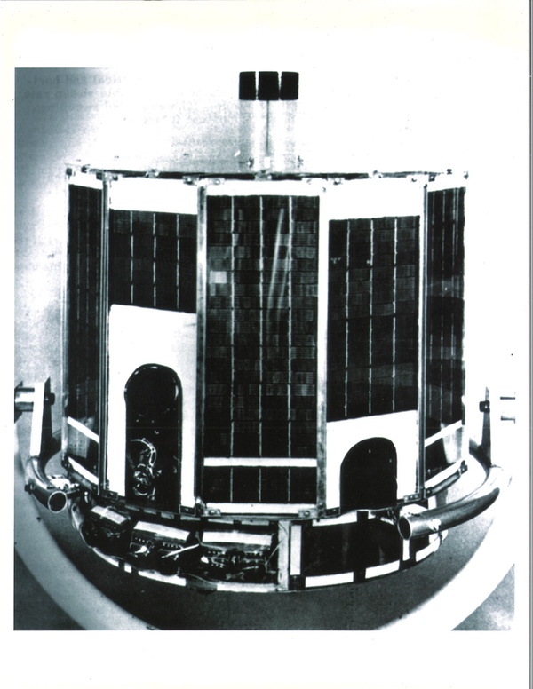
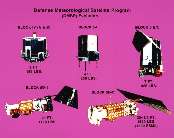 The military weather satellite program consisted of Blocks 1-3, developed and managed by the National Reconnaissance Office. Starting in the mid-1960s, the Air Force developed the Block 4A and 4B, Block 5A, 5B, and 5C satellites. The Block 5D-1 and later Block 5D-2 satellites were significantly different than their predecessors, but the Air Force chose to keep the Block 5 number to avoid scrutiny from the executive and legislative branches. (credit: USAF) |
The Civilian Program Stumbles On
The story of the military weather satellite program is intimately intertwined with the civilian weather satellite program. NASA’s Tiros grew out of a military program. The NRO’s first weather satellite was developed as an “interim” program to bridge the gap until the National Operational Meteorological Satellite System (NOMSS) was developed to serve civil and military users. In 1961 and 1962, military officials expected that eventually the military would not operate its own weather satellites, but would use the data from civilian-operated satellites, possibly with some military sensors onboard.
NOMSS was a NASA and Department of Commerce system with limited military involvement. As it progressed, it was renamed Nimbus. NASA, the agency with experience developing satellites, was in charge. By the mid-1960s, the Department of Commerce, which included the Weather Bureau, was increasingly unhappy with the delays in the program and decided to pursue the Tiros Operational System (TOS) as an “interim polar-orbiting weather satellite.” Tiros 9 was a near-copy of the Program 417 Block 2 satellite—although a little larger—and launched in January 1965. Tiros 10, launched in July 1965, was one of the older series Tiros satellites. In February 1966, NASA launched Tiros 11, officially designated ESSA 1, after the Environmental Science Services Administration. Tiros 11 was nearly identical to Tiros 9, and more satellites of this type were launched thru February 1969.[5]
The Defense Department ended its involvement in NOMSS. NASA leaders converted Nimbus into a research and development satellite. The DoD decision to withdraw the military from NOMSS, and the Weather Bureau’s decision to emulate the military weather satellite technology, led to an obvious question: why did there have to be separate military and civilian systems? This question was hidden behind security barriers throughout the 1960s. But by the early 1970s, as knowledge of the military weather satellite became more well-known, the question started to get asked in unclassified settings.
 In 1967 Air Defense Command took over responsibility for launching Program 417 satellites from Space Launch Complex 10 at Vandenberg Air Force Base. In 1968 it was redesignated Aerospace Defense Command. The 10th Aerospace Defense Squadron launched the Thor Burner launch vehicles at Slick-10. (credit: USAF) |
The new satellite: the Block 4
Before he left command of the program in early 1965, Lt. Col. Haig secured permission to begin development of Block 4 (“Block IV”), a more powerful and capable satellite than its predecessors.[6] The satellites were larger, heavier, and carried more instruments.
| Because of the satellite’s widespread use in Vietnam, word of the program’s existence leaked. |
The Blocks 1–3 satellites weighed 45 kilograms (100 pounds) and were 53.3 centimeters (21 inches) high and 58.4 centimeters (23 inches) across. In contrast, the Block 4 satellites were 73.6 centimeters (29 inches) high, 76.2 centimeters (30 inches) in diameter, and weighed 79 kilograms (175 pounds). The earlier satellites had used a single 1.27-centimeter (0.5-inch) video camera and two infrared systems, the medium-resolution “C” system with 16 sensors in the 0.2 to 5 micron and the 5 to 30 micron bands. They also had a high-resolution radiometer working in the 7 to 14 micron band.[7]
The Block 4 satellites carried updated versions of the original sensors, consisting of two 2.54-centimeter (1-inch) vidicon cameras and tape recorders. The satellite spin was decreased compared to their predecessors, reducing image smear and providing better television picture quality and higher resolution. The satellite was also equipped with two infrared systems.[8]
The satellites used a tape recorder to record images of the entire northern hemisphere, primarily servicing strategic users like the NRO, while they provided direct local tactical weather coverage to small mobile and shipboard terminals. The first four satellites were designated Block 4A and the remaining four were designated Block 4B.
By the later 1960s, Program 417 was serving more tactical users, something that had started when the NRO created the Block 3 spacecraft in 1965 to serve weather needs for forces in South Vietnam. This increasing tactical use of the satellite data attracted attention to the still-secret program. The official story from the Air Force was that the program started in the “mid-1960s,” with the first launch being the September 1965 mission. Officially, three “early” satellites were launched (including a January 1966 failure and March 1966 success) before the debut of the Block 4 satellites in September 1966.[9] Although the Air Force never stated it until Program 417 was eventually declassified in the late 1990s, outside observers were left to assume that the three early satellites constituted blocks 1-3, whereas there had already been 11 Block 1, 3 Block 2, and 1 Block 3 satellites launched.
The first Block 4 satellite was launched on September 15, 1966, and operated for 780 days. In 1967, Air Defense Command took over launches of the satellites at Space Launch Complex 10 at Vandenberg Air Force Base. Seven of the Block 4 satellites were launched between September 1966 and July 1969, with the last satellite finally ceasing operation in March 1971. The last Block 4 satellite built, which was also designated Flight 23, was not launched. Instead, it was eventually donated to the Chicago Museum of Science and Industry.[10]
Because of the satellite’s widespread use in Vietnam, word of the program’s existence leaked. In January 1969 Aviation Week and Space Technology published a small article about the program, without details.[11]
Better serving the users: Block 5A
After he took over the program, Major Kulpa initiated work on a replacement for the Block 4 that was still in development. He delegated spacecraft design and instrument requirements to two subordinates: Captain Richard Geer and Major James Blankenship. The latter had just obtained a Ph.D. focusing on atmospheric photochemistry. Blankenship played a major role in pushing the capabilities of the satellites even further than before.[12]
Both Geer and Blankenship visited meteorologists and listened to their requirements. They adopted a different approach in how the program responded to users, orienting the system to produce data in a form that was easily adaptable to existing weather charts and maps—attuned to the user’s needs as seamlessly as possible.[13]
Instead of the spin-stabilized spacecraft developed for Tiros and the Blocks 1–4 of the military satellites, the Block 5 (“Block V”) satellite would be stabilized on three axes, with the instruments constantly looking down instead of scanning the face of the Earth. This would allow the primary instrument to take a continuous scan along the line of flight. Satellite height increased to 121.9 centimeters (48 inches), although the diameter remained 76.2 centimeters (30 inches). Weight rose to 104 kilograms (230 pounds). According to historian Cargill Hall, in orbit “it closely resembled an overturned garbage can.”[14]
| Whereas the early satellites developed by the NRO had been small, almost elegant drums covered with solar cells, the “overturned garbage cans” were looking even more clunky. |
Experimental sensors were flown in a T-39 aircraft, proving that the concept could work, and Kulpa, now a lieutenant colonel, obtained approval to begin development of Block 5. The program office held a source selection competition in May 1966. RCA won the contract to provide the spacecraft bus, with Westinghouse winning the contract to provide the constant resolution oscillating telescope sensor and ground display equipment, referred to as the Westinghouse Operational Line Scanner, or OLS for short. “Special sensors” were also added that increased what the satellites could measure.[15]
The Block 5A sensors were designated the Sensor AVE Package, consisting of a radiometer with three main data collection and processing channels: an infrared data channel, a high-resolution visible data channel, and the very-high-resolution visible data channel.[16] The higher resolution system satisfied tactical users. The infrared system provided 3.7-kilometer (2-nautical-mile) resolution at the surface day and night. It also provided cloud-height profile and identification of all clouds above or below a selected altitude, as well as heat-balance data.
The Block 5 satellites satisfied the strategic (NRO) and tactical users, and according to Kulpa, Blankenship took “shameless advantage of that fact, telling tactical and strategic customers, in turn, that Block 5 had been designed entirely for them.”[17]
The spacecraft used a momentum-bias attitude-control system. It consisted of a momentum wheel and horizon scanner and magnetic coils. The wheel and scanner controlled pitch, while the magnetic coils controlled roll and yaw.[18]
Three Block 5A spacecraft were built. The first Block 5A was launched on February 11, 1970, also from SLC-10 at Vandenberg.
Tactical use increases: the Block 5B
By 1969, after the satellites had provided weather data for several years to forces in Vietnam, and after the deployment of ground stations in other locations such as South Korea and Hawaii, there was greatly increased interest from tactical users. But continued secrecy limited the distribution of the data. The Navy was also interested in receiving information directly onboard ship rather than relayed from a ground station.[19] The demand from military users was increasing as the usefulness of the satellite data also increased. According to an official history, “in December 1972, meteorological data also began to be furnished routinely to the Department of Commerce/National Oceanic and Atmospheric Administration and its National Weather Service at Suitland, Maryland. At that time, security restrictions on tactical applications were removed. Program classification was reduced from Secret Special Access Required to Secret.”[20]
A few months later in March 1973, Under Secretary of the Air Force and NRO director John L. McLucas publicly announced the existence of the Defense Meteorological Satellite Program (DMSP) in a Pentagon press conference.[21] For several years, the program had operated under the deliberately obscure designation Defense Satellite Application Program, now replaced by the new name. An unclassified DMSP mission statement was issued June 8, 1973, and work began on a new program classification guide.[22]
The Block 5B (“Block VB”) DMSP satellites added a high-resolution infrared channel and had additional sensors. Each satellite normally carried two special sensors, although these varied depending upon specific needs as well as the condition of sensors on older satellites already in orbit.[23]
Block 5B spacecraft added a large sunshade on the satellites that flew over their targets in the early morning, referred to as the “morning birds,” which was unnecessary for the satellites that overflew their targets in mid-day, known as the “noon birds.”[24] Whereas the early satellites developed by the NRO had been small, almost elegant drums covered with solar cells, the “overturned garbage cans” were looking even more clunky. Five Block 5B satellites were launched.
 A Block 5C satellite and its launch vehicle in 1975. In this image the top side of the satellite (the side facing the ceiling) would have faced the Earth, with its instruments near the base pointing toward the Earth's surface resembling what one person called "an overturned garbage can" in orbit. This was the last successful Block 5C satellite. A launch in 1976 failed to place the satellite in orbit due to an error loading propellant in the launch vehicle. (credit: Joseph T. Page II/Peter Hunter Collection) |
DMSP Block 5C
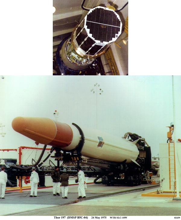
The Block 5C added a vertical temperature/moisture profile sensor. It also included an improved infrared sensor with a resolution of 3 microns at the Earth’s surface. Various other special sensors were added to the satellites over the years.[25] Three Block 5C satellites were eventually launched. The second-last Block 5 satellite was launched on May 23, 1975, and operated until November 30, 1977, a record 922 days.[26]
The last of the Block 5C satellites was launched on February 18, 1976, but failed to achieve orbit due to a rather embarrassing mistake: somebody made an error in calculating the fuel loading for the rocket and its upper stage engine burned out too soon. The satellite could not reach orbit and fell back into the atmosphere. This loss proved to be an omen of further problems to plague the DMSP office for the rest of the decade, and beyond.
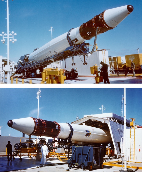
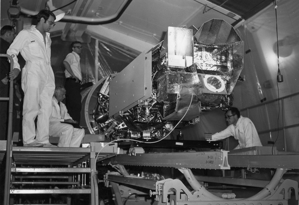 A DMSP Block 5D-1 satellite being prepared for launch at Space Launch Complex 10 at Vandenberg Air Force Base in the latter 1970s. The Block 5D-1 was larger and more complex than its predecessor, but underfunding and mismanagement led to problems with the satellites during their era of service. (credit: Joseph T. Page II) |
Going big: the DMSP Block 5D-1
By the early 1970s. it was clear that the Block 5 satellites were reaching the limits of their growth potential. More users were taking advantage of the data and wanted greater accuracy and additional sensors. Providing this would require a substantially larger satellite. In addition, the Air Force wanted to significantly increase satellite lifetime, but this would require adding redundant systems that could take over when one failed. A bigger satellite was needed.
| The last of the Block 5C satellites failed to achieve orbit due to a rather embarrassing mistake: somebody made an error in calculating the fuel loading for the rocket and its upper stage engine burned out too soon. This loss proved to be an omen of further problems to plague the DMSP office for the rest of the decade, and beyond. |
This new satellite was initially referred to as the Block 6. All the previous block updates to the satellites had been managed in a classified environment, but this was the first that would occur with limited classification. The Air Force became concerned that an entirely new block change number would indicate a new program start, which would naturally invite congressional scrutiny and oversight from the Office of Management and Budget. To avoid that, the Air Force decided to name the new satellite Block 5D. Prior to this, the earlier satellites had received Roman numerals—Block I, II, III, IVA and IVB, and VA, VB, and VC. Perhaps to further confuse potential overseers, someone decided to change the designation to 5D using an Arabic number.[27]
The Block 5D satellites were very different than their predecessors.[28] Block 5D added redundancy to increase lifetime to a 18-month goal, double the lifetime of the 5C.[29] They also had a much higher requirement for Earth-oriented pointing accuracy. In fall 1972, RCA won the competition to produce the new satellites and signed a contract to build five Block 5D satellites. The launch date was set for fall 1974. But the higher complexity of the satellites increased their cost, and resulted in a two-year delay during development.
The earlier blocks had all been drum-shaped, but the 5D would have a different configuration. The Block 5D design was substantially larger than the 5C. It was 1.52 meters (5 feet) in diameter and 6.1 meters (20 feet) long, weighing 552 kilograms (1,150 pounds), five times as long and more than twice as heavy as the satellite it replaced. It was composed of three sections. These consisted of a circular reaction and control-equipment support structure that included the spent third stage solid-propellant rocket motor as well as reaction control equipment. The aft section also included a deployable 1.8-by-4.9-meter (6-by-16 foot) sun-tracking solar array. The middle section was a five-sided equipment-support module containing most of the electronics. It also featured one or two pinwheel louvers on four sides. These louvers could be opened or closed to provide the proper internal temperature for the electronics. The forward section was a precision-mounting platform that supported the sensors and other equipment that provided precise alignment of them.[30]
The satellite now had a modified Burner II-type rocket motor integrated into its rear section. It was mounted above another modified Burner II-type second stage atop the Thor. The attached solid rocket motor was used during ascent to perform the final injection into the circular, sun-synchronous 833-kilometer (450-nautical-mile) orbit.[31]
The new satellites were equipped with an improved Westinghouse electro-optical Operational Linescan System. This included a scanning optical telescope and moved side-to-side. It covered a swath width of 2,963 kilometers (1,600 nautical miles) with a resolution at nadir (straight down) of 0.6 kilometers (0.3 nautical miles) in the visual and infrared spectra and 0.9 kilometers (0.5 nautical miles) at the edges. The satellite had three tape recorders to record this data, as well as providing direct readout to tactical users. The satellites recorded so much data that it strained the existing leased land lines from the ground stations to Offutt Air Force Base’s Air Force Global Weather Central, so the Air Force leased commercial communications satellites to transmit the data from the ground stations to Offutt.[32]
The Block 5D satellites added new sensors such as an atmospheric density sensor that measured nitrogen, oxygen, and ozone in the Earth’s thermosphere during daylight passes. They also carried a precipitating electron spectrometer to count ambient electrons. A scanning infrared radiometer provided vertical temperature profiles and vertical water vapor profiles and the total ozone concentration. A passive microwave-scanning radiometer produced global atmospheric temperatures from the Earth’s surface to altitudes above 30 kilometers. The sensors were used to improve weather forecasting models. The satellites also added an entirely new sensor, a gamma-radiation sensor that could detect nuclear explosions and was part of the Integrated Operations NUDET Detection System.[33]
The secondary sensors were not important for the primary mission of supporting satellite reconnaissance missions. However, their incorporation into the satellite increased complexity and slowed integration.[34] This was only one of numerous problems that began to accumulate for the DMSP office.
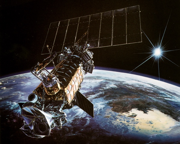 he Block 5D-2 satellites entered service in 1982, over four years behind schedule. They were larger than the 5D-1 satellites, and had 2-3 thermal control louvers on their sides compared to the 1-2 on the Block 5D-1. They successfully operated for the next several decades. (credit: USAF) |
Block 5D-2
Even before the first of the 5D satellites was launched, the program office began work on their successors. The first five satellites were then designated Block 5D-1 and the follow-on satellites were designated Block 5D-2. The 5D-2 satellites were an evolutionary improvement over their predecessors and the plan was that they would begin entering service by 1978. They were designed to have a two-year lifetime and other upgrades. One of the solar arrays produced 25 percent more power, and the computers were more capable and the sensors more advanced. Whereas the 5D-1 had one or two louvers on each side for reducing the interior temperature, the 5D-2 now had two to three louvers on each side. The satellite was also heavier than the 5D-1.[35]
The increase in satellite weight resulted in the payload being too big for the existing Thor-Burner launch vehicle. But there was a delay in selecting a new vehicle, in part because Thor was the only launch vehicle that was still launched by Air Force personnel. The satellites were also equipped to encrypt their telemetry to the ground, but this required development of a new ground station, which also resulted in delays that had pushed out the first launch.
Despite the external pressure on the program—real or imagined—parochial interests within the Air Force itself had led to delays that eventually came back to bite the Air Force.[36]
page 2: going higher, and Lazarus >>