Not necessarily for the NRP: Final thoughts on the Casa Grande crossesby Joseph T. Page II
|
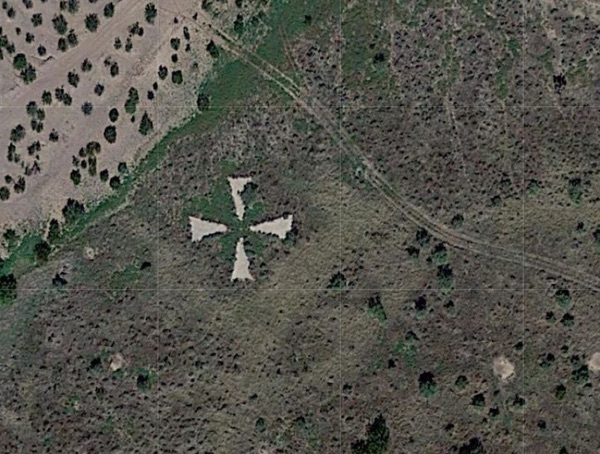
 Image 1: Cover of the 1975 Proceedings of the American Society of Photogrammetry |
Exhibit #1: Proceedings of the American Society of Photogrammetry
From October 26 to 31, 1975, the American Society of Photogrammetry held a symposium in Phoenix, Arizona, under the tagline “Saddle to Satellite: Progress in Our Profession.” A representative of the Defense Mapping Agency, Mr. David D. Byars, spoke about the Casa Grande Photogrammetric Test Range outside of Tucson. Based on his previous job as the Chief of the Americas Division inside the Department of Geodesy, Army Mapping Service (AMS), and his position at the Defense Mapping Agency in 1975 and previous AMS experience, I consider Byars’ words authoritative.
The abstract for Byars’ talk reads:
The Casa Grande Photogrammatic (sic) Test Range was established· in the mid-sixties to test the dynamic performance of aerial cartographic cameras. A discussion of-the test range design and the field surveys required to establish it is presented. In addition, the photogrammetric procedures normally used to test aerial mapping cameras using the range are presented. [1]
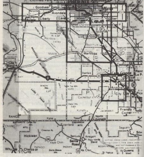 Image 2: Location comparison of Arizona Test Range and Casa Grande Photogrammetric Test Range |
In 1947, the Army Map Service established the Arizona Test Area, covering an area of approximately 1,000 square miles (2,600 square kilometers) encompassing Phoenix. The range was enlarged in 1960, however, and by 1965 an expanded, more accurate range was required for performance and evaluation of dynamic camera systems. A range in Ohio—the McClure Range—offered the accuracy required but was deemed too small. The Arizona Test Range provided the size but with decreased accuracy. With the limiting factors of overflight restrictions, terrain, weather, and land lease costs, the Casa Grande, Arizona, area was selected, with the range encompassing a perimeter of 16 by 16 miles (26 by 26 kilometers) and holding large concrete panels in the shape of a Maltese cross.
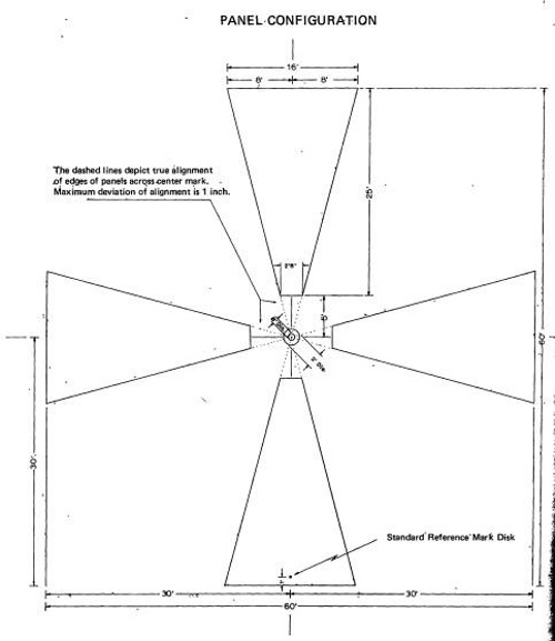 Image 3: Dimensions of Casa Grande Cross panels |
Across the Arizona desert, the concrete panels were built at every location where the terrain permitted. The target’s Maltese cross shape was selected to be compatible with associated aerial mapping camera reticles that were common to stereo mensuration and other types of plotting equipment at various altitudes. The size of the panels—16 feet (4.9 meters) across the large end of each wing—was selected to provide the best compatibility with operational altitudes of aerial cameras, ranging from low (called “on-deck” in the paper) to typical heights from reconnaissance aircraft. The wings were oriented to match the cardinal directions, and a center concrete post held a bronze survey marker, as shown in Image 3.
| Two authoritative primary source documents plainly stated the range was used by the United States government to test dynamic performance of aerial cartographic cameras. |
Local agricultural activities caused subsidence problems with the surveyed markers. Since the subsidence was not continuous, but cyclic based on the growing season’s use of groundwater for irrigation, the Defense Mapping Agency attempted releveling of the sites from 1968 to 1971 but did not include every panel on the range. By 1971, DMA ceased performing any remedial releveling or repairs to the crossed due to budget cutbacks, and found no extensive problems with the elevations when testing aerial cameras.
Byars’ paper noted the types of systems that were tested at Casa Grande:
- Dynamic tests of the Wild RC-9 camera inside a RC-130
- Dynamic tests of a KC-6A camera inside a RC-135
- Color film tests
- High altitude reconnaissance aircraft (no types were specified)
- Terrain profile recorders and laser altimeters
Up to the 1975 publication date of the paper, the US Air Force had tested around 25 aerial cameras per year over Casa Grande. Of special note was the inclusion of cameras to be employed by the Earth Resources Technology Satellite (ERTS, later renamed Landsat.) The future tense of Byars’ statement leads to a presumed conclusion of an airborne test of the ERTS camera, which provided an 80-meter (262-foot) ground resolution.[1]
 Image 4: Cover of the 1965 Controlled Range Network Manual |
Exhibit #2: The 1965 Controlled Range Network (CORN) Manual
Starting with Corona KH-4A Mission 1001 (August 1963), the Air Force Special Projects Production Facility (AFSPPF) at Westover Air Force Base, Massachusetts, became the primary processing and duplication facility for the NRP. Prior to this switch, the Eastman Kodak Company had been processing reconnaissance imagery at a Rochester, New York, facility for the Central Intelligence Agency (CIA) since the first clandestine flight of the U-2 and from the first successes within the Corona program in August 1960. [3]
During the summer of 1962, AFSPPF contracted a research study with the Mead Corporation to create methods for assessing on-orbit reconnaissance camera system performance. In October 1963, Mead was awarded a contract to maintain and operate a ground target system—the Controlled Range Network (CORN)—to provide valuable information on image analysis, edge analysis, micro-densitometry, and negative evaluation techniques. CORN consisted of a mixture of fixed and mobile sites, using military standardized (MIL-STD-150A) tri-bar targets and gray scale targets at specified geographic locations. [3] (Note: there were CORN targets in Arizona: one fixed site near Sierra Vista and temporary mobile sites near Luke AFB, which will be described in a future article.)
| I can reasonably conclude that the Casa Grande/Arizona Test Range had no significant, if any, role in the NRP. |
Conferences were held to bring interested parties together to be briefed on the current operational procedures and capabilities of the program’s resources. In July 1965, a large CORN symposium was held at Wright-Patterson AFB in Dayton, Ohio, with 250 people from the different military services, government agencies, and photometric, infrared, and radar equipment manufacturers attending, as well as the operational users. Attendees were informed about the network’s capabilities through a reference book called the CORN Manual, while they were briefed on the network’s function as test facilities/capabilities for fixed wing and helicopter aircraft systems. This allowed the symposium to act as a cover for CORN’s connection to the NRP. (An additional symposium held in 1968 at AFSPPF would have all attendees be read into the compartment detailing the support to the NRP.) [4]
The CORN Manual described the unclassified operation of the program, each fixed site, each type of mobile target, the mobile multisensory targets, and the different target ranges (photogrammetric, radar, and infrared) available around the US. [2]
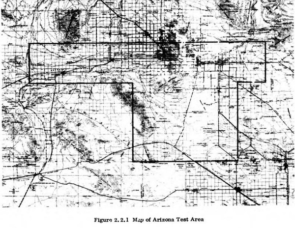 Image 5: Map of Arizona Test Area inside 1965 CORN Manual |
The 1965 CORN Manual’s adjunct ranges (those not directly associated with CORN, but available to DoD users) includes an entry for the Arizona Test Area, listed as a “photogrametric [sic] range with a large area extending East, West, and South of Phoenix.” The narrative description states this Arizona Test Area was:
“…Designed for the test and evaluation of aerial cameras and mapping techniques, this range is based on existing road networks and utilizes precision ground surveys to achieve a high degree of accuracy in the knowledge of point position.” [2]
Notably missing from the description is the inclusion of the Casa Grande area as a stand-alone range. The range entry provides an image of a “T-shaped area,” which was denoted in Byars’ paper as the 1947 range, along with the 1960 additional expansion.
The rest of the CORN manual provided details for the many other optical test ranges around the United States, include descriptions of the fixed CORN sites with the tri-bar panels, which have been identified inside NRO literature as being part of the NRP and used within the Corona, Gambit, and Hexagon programs.
Based on the evidence of both Arizona Test Range and CORN targets being described in the CORN manual, yet only CORN tri-bar targets descriptions are included in many Photographic Evaluation Team (PET) reports for Corona, Gambit, and Hexagon missions, I can reasonably conclude that the Casa Grande/Arizona Test Range had no significant, if any, role in the NRP.
Additionally, the AFSPPF’s declassified history clearly states:
“Initially, CORN was the only performance measure used for [the CORONA] program. As this was the first program to use CORN, no experience existed for this resource to support a satellite reconnaissance system, thus operating procedures, targets, and analysis methods had to be developed and tested. CORN provided system performance data for CORONA, which consisted primarily of tri-bar resolution readings.” [4]
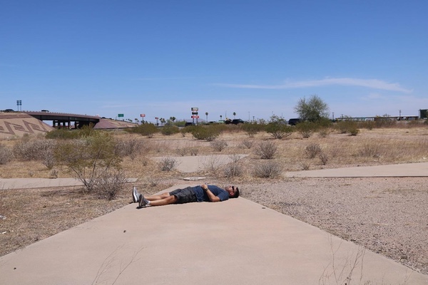 Image 6: Author at one remaining Casa Grande Cross. Individual’s height is six feet (1.8 meters) for size comparison.
|
“Concrete” Conclusions
Being a conscientious space and missile historian, I recently visited one concrete cross near a truck stop off Interstate 8 (N32.8075823275429, W111.67042465065327). [5] I took photos of the concrete wings and the center bronze marker during a balmy 110 degree Fahrenheit (43 degrees Celsius) afternoon. After returning home, I decided to load the above “silver bullet” references and fire off this article, considering the topic closed and the myth of a Corona connection to the Arizona concrete crosses dead.
References
- Byars, David D. The Casa Grande Photogrammetric Test Range. Proceedings of the American Society of Photogrammetry. Phoenix, AZ, Oct 26-31, 1975.
- Air Force Systems Command. The 1965 Controlled Range Network Manual. Photographic Branch, Research and Technology Division, June 1965.
- Office of the Secretary of the Air Force (SAF/SP). Air Force Special Projects Production Facility History Volume I: Overview. Westover AFB, MA: Directorate of Special Projects, 1976.
- Office of the Secretary of the Air Force (SAF/SP). Air Force Special Projects Production Facility History Volume II: Resources. Westover AFB, MA: Directorate of Special Projects, 1976
- Written communications with Mr. Mark White.
Note: we are using a new commenting system, which may require you to create a new account.