Mapping the dark side of the world (part 2): supplementing, and supplanting, the ARGON geodetic satellite programby Dwayne A. Day
|
| But even before the first ARGON mission failures, both the Army and the Air Force were considering replacements for ARGON. |
This effort, led by people like Chris Mares and John Cain of the newly created National Photographic Interpretation Center (NPIC), and William Mahoney of the Air Force’s Aeronautical Chart and Information Center (ACIC), became more urgent after the Soviets detonated a 58-megaton nuclear device in October 1961. The Soviet test prompted US defense analysts to look closely at American nuclear weapon targeting policy.[1] US defense planners wanted to know the exact distances between nuclear targets in the Soviet Union. This would allow them to determine if a target required more than one bomb to destroy it, or if multiple targets could be destroyed with a single weapon. CORONA reconnaissance photographs could be used to employ American nuclear weapons more economically.
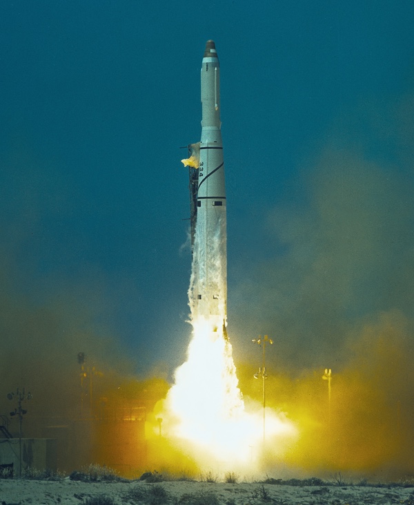 Launch of the fifth ARGON mapping mission from Vandenberg Air Force Base in May 1962. This was the first successful ARGON mission after four failures. (credit: Peter Hunter) |
Unfortunately, CORONA photographic material was not ideally suited to this purpose. Its panoramic geometry, though very precise, did not represent the same amount of ground area at different points on the image.[2] The intelligence analysts had to develop special equipment and techniques to correct for such scale change. The most important of these was the Ashenbrenner printer, an optical device that rectified panoramic imagery into equivalent frame geometry.[3] Once they performed this rectification, the strategic planners could more easily decide where to target their missiles.
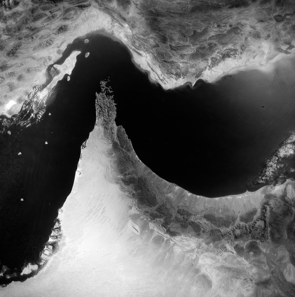
 This ARGON image of Istanbul was returned from the first successful ARGON mission in May 1962. (credit: Via Harry Stranger) |
Geodetics and the Bombing Encyclopedia
In addition to mensuration, there was another high priority for reconnaissance satellites: geodetic positioning of targets in a unified world geodetic system (WGS). In more simple terms, this meant precisely locating targets in relation to other known Earth features. American geodesists already had several existing interconnected national geodetic reference systems in their libraries. These relied upon sometimes extremely outdated surveys, and stretched over the continents. The continents in turn were connected over bodies of water such as the Atlantic Ocean and the Bering Strait by astronomic measurement.
However, these geodetic nets were not referenced to a single WGS. Much of the data, particularly for northern and western China, was very sketchy. In the mid-1960s, when NPIC intelligence analyst Dino Brugioni was attempting to help some photo-interpreters locate the site of the Chinese nuclear weapons test facility at Lop Nor, the best he could come up with was a survey that had been done in the 1930s, and an account by Marco Polo, who had travelled through the area.[4] The exact geodetic location of many geographic positions in these areas was known to a distance of no better than 20–30 nautical miles (37–56 kilometers), and no better than 2–3 nautical miles (3.7–5.6 kilometers) for many parts of the Soviet Union. If the United States wanted to send an ICBM over the North Pole and hit one of these places, military planners needed a much better set of WGS target coordinates. The KH-5 ARGON geodetic satellite, and its camera manufactured by the Fairchild Camera and Instrument Company, was supposed to correct this. But after the first four ARGON missions were unsuccessful, there were no additional ARGON cameras ready for launch before the onset of winter. Mapping the Earth’s northern regions is virtually impossible during winter due to snow, cloud cover and other atmospheric effects. The next ARGON launch would not take place until May 1962.
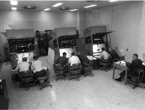 Photo-interpreters at Strategic Air Command looking at U-2 and other imagery during the Cuban Missile Crisis. Often while looking at higher resolution reconnaissance images, the interpreters would also consult lower resolution “index” images that showed a larger area, enabling them to determine what areas they were looking at. (credit: NRO) |
In the meantime, several CORONA missions flew and successfully returned panoramic imagery to photo-interpreters. This imagery, although it had medium ground resolution (by 1962 standards) and excellent local geometry and was currently being used for mensuration, was not calibrated for geodetic positioning. But it was the only thing available until ARGON could get flying, and because of its availability and the need for the data, Mapping, Charting and Geodesy (MC&G) experts at the Air Force’s Aeronautical Chart and Information Center attempted to do the most with it. Although this type of work is best done from separate mapping cameras, ACIC’s experts had gained experience adapting the U-2 aircraft photography for similar purposes and felt confident that they could do the same with the CORONA images.
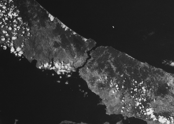
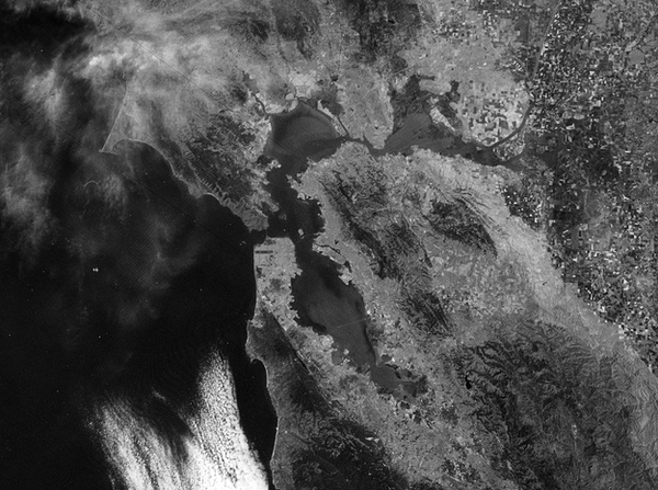 An ARGON mapping satellite image of San Francisco taken in 1964. Although ARGON was a good mapping camera, it required an entire rocket and spacecraft. By the mid-1960s, the National Reconnaissance Office was considering ways to incorporate the mapping camera into reconnaissance missions to improve efficiency. (credit: Via Harry Stranger) |
As CORONA gathered data on new targets within the Soviet Union—and new targets were showing up by the dozens with each mission—the location of the targets had to be fixed by connecting them to the existing geodetic data systems. Once this was done, the target was added to the BE, or Bombing Encyclopedia, used for strategic targeting. The next step, from a MC&G point of view, was to develop charts for the bomber crews that would attack the targets. So, CORONA data was used to map ingress and egress routes to the target. Over time, the photogrammetrists and geodesists developed a better mapping picture of the Soviet Union, while at the same time working towards achieving the ideal reference WGS.
| Carrying additional payloads was a typical occurrence for CORONA. “Any spare room in the satellite and we’d squeeze something in,” said one CIA official. |
This was very much an ad-hoc approach to the problem, because the systematic approach to developing mapping systems was not progressing very well. But even before the first ARGON mission failures, both the Army and the Air Force were considering replacements for ARGON. In September 1959, the Army had initiated a feasibility study for an “Army Satellite Mapping System.” In June 1960, it published the report and in January 1961 the Army submitted its plan to Herbert York, the Department of Defense’s Deputy Director of Research and Engineering (DDR&E), who was responsible for approving all new technology development. In April, the DDR&E approved the Army plan but halted the program a month later in response to Air Force proposals to satisfy Army requirements with either its revived 6-inch (15-centimeter) focal length SAMOS E-4 mapping camera, or with CORONA panoramic photography. The first successful ARGON mission occurred in May 1962, and this mission might have prompted the DDR&E to issue Directive No. 74, formalizing the Army’s project. The Army program proceeded on schedule until August 1962, when York stopped all work on the program once again, stating that a “new mapping satellite program [is] not warranted at this time.”[5] It was a frustrating time for the Army mapping community.
 The KH-4A CORONA had two Stellar-Index cameras, the small boxes at the bottom left, below the reentry vehicles. Each camera fed its film into its own reentry vehicle. (credit: NRO) |
The Index camera
In July of 1960, both Itek and Lockheed, two of the prime contractors for the CORONA reconnaissance satellite program, proposed an upgraded version of the KH-3 CORONA satellite, which itself was still in the development phase. Instead of using one C’’’ (“C Triple Prime”) camera, the system would use two, mounted at an angle to each other. Both cameras would operate while over a target and this would provide two images, at slightly different angles, which could be viewed stereoscopically and provide better height information of the target. The overall value of the imagery to various users would be dramatically enhanced by this new development. The companies made this proposal even before a single CORONA satellite had successfully returned film, but received tentative approval from the CIA to proceed with development. The CIA named the new camera MURAL.
The first MURAL camera, KH-4 CORONA Mission 9031, was launched on February 27, 1962. In addition to the far bigger main camera payload compared to the earlier KH-3 CORONA spacecraft, this mission also included an Index camera.
While the KH-3 was flying in 1961 and 1962, photo-interpreters at NPIC who studied the CORONA photography and MC&G experts at ACIC had suggested adding an Index camera to the spacecraft. Although CORONA imagery was getting steadily better, its inherent errors and the small area it covered made it difficult to connect one image to another and to existing geodetic nets. The location of objects could only be determined to several miles based upon the orbital track, altitude and attitude of the spacecraft, and the precise time that the photograph was taken. This was not accurate enough for ICBM targeting purposes. Furthermore, the photo-interpreter’s job would be made much easier if he had a way of determining what general area of the Earth each individual frame showed and matching the images up to a smaller scale photographic reference system was the way to achieve this.
William C. Mahoney, a CORONA photogrammetrist with ACIC, suggested to the NPIC representatives, Chris Mares and John Cain, that while the MURAL camera was in development, NPIC should approach the CORONA camera’s manufacturer, Itek, about the extra camera. Mares and Cain mentioned it to Ron Ondrejka of Itek, who came back about a month later and said: “You know, I think we can get that camera you want because we’ve found a hole in the CORONA vehicle where we can pack it.”[6]
 The family of CORONA reconnaissance systems. ARGON and LANYARD used many of CORONA’s equipment. The red circles indicate where Index and Stellar-Index cameras were added to CORONA spacecraft. The Index camera was not a dedicated mapping camera, but it provided some mapping capability. (credit: NRO) |
This was a typical occurrence for CORONA. “Any spare room in the satellite and we’d squeeze something in,” said one CIA official.[7] Extra experiments were carried on the Agena “aft rack” and occasionally flown as separate payloads. Small experiments were also sometimes stuffed into the reentry vehicles.
The “hole” the spacecraft designers found was between the Satellite Recovery Vehicle (SRV) and the forward CORONA panoramic camera. It was just big enough to fit a small additional camera. The new camera was named the “Index” camera.
Mahoney had argued for including the Index camera on the CORONA. As he stated “It didn’t have all the bells and whistles that we would’ve liked to have on it, but the KH-4 ‘bird,’ as we called it, was the first bird that was adapted to support MC&G mapping and target location requirements.”[8] It was a way to start getting some of the data they needed fast, even if it wasn’t as good as ARGON was supposed to be.
 GAMBIT-3 satellites under construction at Eastman Kodak in Rochester, New York. Although most Index cameras were carried on CORONA satellites, a few were carried on GAMBIT missions. (credit: NRO) |
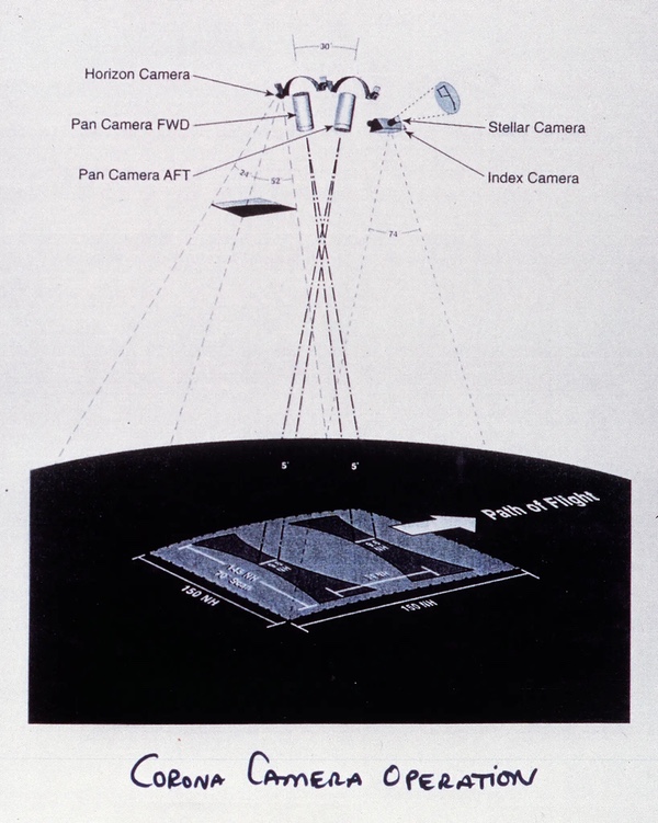
ltek’s engineers chose a commercially available Hasselblad camera to serve as the Index camera. The Index camera had a 1.5-inch (3.8-centimeter) focal length and a ground resolution of 400–500 feet (121–152 meters). It imaged an area approximately 166 miles (267 kilometers) on a side, the same swath width of the panoramic imagery.
The Swedish-manufactured Hasselblad with its German Zeiss optics was a very high quality camera long used by professional photographers. Hasselblad cameras were carried on most American space missions and were used on the Moon by the Apollo astronauts. But in 1961 the Hasselblad was intended for use in a photography studio, taking photographs of fashion models and moodily-lit tubes of toothpaste. It was not designed for use in a weightless vacuum, taking photographs of Earth. In the zero-gravity vacuum of outer space it was possible that lubricants and sealants could evaporate and condense on a cold lens surface, thereby fogging the image. The camera was also not designed to carry the heavy amount of film required for use in space. It therefore required considerable redesign, and Itek established a special team led by project engineer Rick Manent to accomplish this.
The film for the Index camera was supplied by a new film cassette. After each image was taken with the Index camera, two things had to happen: the film had to advance by one frame, and the shutter had to be re-cocked for the next shot. ltek’s original design accomplished both tasks nearly simultaneously and very quickly. But this created a problem: the film sometimes moved so fast that the mechanical device for stopping it did not have enough time to move back into position. As a result, more than one frame would advance through the camera and waste film. Eventually, the mechanism would become damaged and the film would no longer advance at all.[9]
The problem was solved shortly before the first launch in February 1962, but Manent, who was responsible for the Index camera, had to travel to the West Coast to verify the readiness of the camera already awaiting launch. He determined that a few minor corrections should be made. But there was a proble:- once a spacecraft had been designated “flight certified,” no one was officially allowed to make any more changes to the vehicle. So, while two Itek employees (Grant Ross, the Field Service Manager, and Ed Sinram, the Field Service Technician) kept the Lockheed payload engineer occupied, Manent made his minor changes.[10]
Despite these last-minute adjustments, Manent and Ross were nervous about the operation of the Index camera. They phoned Itek management back in Massachusetts for guidance. Management informed them that if the Index camera was either not flown or if it failed, the government was likely to cancel the contract. They also, exercising management’s prerogative to avoid responsibility if possible, informed the men that the decision was entirely up to their on-the-spot judgement. The engineers, faced with this dilemma, decided to have a few drinks in their hotel room and deliberate. The beer did not help them reach a decision and ultimately they decided to toss a coin. It came up heads and the unit flew. It worked perfectly.[11] In operation, it took one image for every seven panoramic exposures, allowing the photo-interpreters to better fit their panoramic imagery together based upon the larger image. It also enabled the MC&G experts to crudely connect the images to the existing geodetic data nets, but still better than nothing.[12]
| The engineers decided to have a few drinks in their hotel room and deliberate. The beer did not help them reach a decision and ultimately they decided to toss a coin. It came up heads and the unit flew. It worked perfectly. |
A few months later ARGON returned its first image and late in the fall, after another failure, a second successful ARGON mission returned even more film. But Index cameras were flying on every single CORONA mission and did not require their own dedicated satellite and launch vehicle. The Index camera imagery returned from the KH-4 CORONA missions was less than ideal for geodetic work, but it was prolific, and flying it piggyback on another vehicle was more efficient than using an entire rocket and spacecraft for each ARGON mapping mission. While there were only three ARGON missions in 1962, there were 17 CORONA missions.[13]
The MC&G experts’ growing experience with using both the CORONA and Index cameras from 1962 to 1964 was subtly wearing away at the arguments for dedicated mapping missions like ARGON.
 Launch of the eighth ARGON mission in April 1963. (credit: Peter Hunter) |
The Stellar-Index camera
While this struggle over a dedicated successor to ARGON continued, the contractors worked on improving the limited Index camera. As Fairchild engineers had done with ARGON, Itek engineers soon added a Stellar camera to take a simultaneous starfield image with the Index camera. As part of this new design, the operation of the Index camera was also slowed down. It still took Images at the same rate, but the mechanical operation of the different parts was spread out so several functions of the camera took place sequentially instead of simultaneously. This reduced the wear and tear on the camera and increased its reliability.[14]
Early versions of the Index camera had a slight distortion problem caused by the camera’s shutter. The camera used a focal plane shutter which pulled a curtain with a narrow slit across the film. As the exposure slit moved across the film, one part of the film was exposed before the other while the satellite moved over the Earth. Thus, the image was not square, but slightly skewed, like a trapezoid.
 The Stellar-Index camera on CORONA missions took a photo of a large area of Earth, which enabled photo-interpreters to look at the higher resolution panoramic images and situate them within the overall area. (credit: NRO) |
To solve this problem, Itek engineers chose to incorporate a between-the-lens shutter into the Stellar-Index cameras. This shutter was located between the front and rear lens element groups so that the entire film was exposed at the same time. A precision flat glass plate with a reseau grid was also installed at the focal plane. The grid was precisely scribed and measured. By measuring the grid lines on the recovered film, the photo-interpreters could compensate for film distortions induced by temperature changes and film processing.[15]
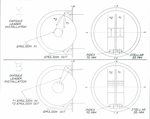 KH-4 CORONA satellites had a single reentry vehicle and KH-4A CORONA satellites had two. They included takeup reels for the reconnaissance film. They also included smaller takeup reels for the film from Index and Stellar-Index films. (credit: NRO) |
The new shutter presented a problem. It was manufactured by the Wollensak Optical Company of Rochester, New York, a commercial firm which was not cleared for the high security CORONA program and could not be told that the cameras were going to fly in space. Wollensak chose talcum powder as a shutter blade lubricant. This was not acceptable for space use and Itek engineers suggested the use of whale oil instead. But whale oil cost approximately $11,000 per gallon (3.78 litres) at the time and Wollensak Optical refused to use it. Itek therefore accepted the new shutters with talcum, disassembled them, cleaned and lubricated them with whale oil, and reassembled them. Only a drop of whale oil was used for each shutter. Years later, Frank Madden, who was ltek’s CORONA program manager, wrote: “Somewhere, sitting in ltek’s basement, is a gallon of leftover whale oil.”[16]
The Stellar-Index camera also suffered a problem with static buildup that fogged the more sensitive film used to capture the faint star images. If the problem was not fixed, it would have obliterated the stars.[17] This was solved through a complex trial-and-error process Frank Madden had used to solve similar problems with the CORONA cameras: the film rollers were steamed in a pressure cooker, and then fitted in a camera and tested. If they produced static, they were rejected. If they did not, they were tested again and then accepted. Other minor problems were also solved as they arose.
| Only a drop of whale oil was used for each shutter. Years later, Frank Madden, who was ltek’s CORONA program manager, wrote: “Somewhere, sitting in ltek’s basement, is a gallon of leftover whale oil.” |
Like ARGON, the precise angular relationship between the Index and Stellar cameras had to be calibrated. This was done at ltek’s Boston manufacturing site in the early morning darkness. Boston is not known for its clear weather, and cloudy days plagued these tests, resulting in several cameras being qualified and shipped simultaneously. After they were shipped to the West Coast and installed in the spacecraft with the panoramic cameras, a group of targets were positioned so that they could be photographed simultaneously by the panoramic and Stellar-Index cameras. This determined the geometric relationship between the cameras and the Agena spacecraft.
The film from the Index and Stellar-Index cameras was taken up on a spool in the Satellite Recovery Vehicle just below the main spools for the panoramic film. When a second SRV was added to make the KH-4A CORONA system, a second Stellar-Index camera was added as well—one for each SRV. This was simpler than trying to re-route the film in flight.
The redesigned camera incorporating the new shutter and other changes was approved on April 1, 1966. It had to launch by the end of July. In that time, the Itek team designed and fabricated the parts, performed various qualification tests, and shipped the flight unit to the West Coast. ltek’s engineers worked overtime, deferred their vacations and were ultimately able to deliver on the contract. By the end of the program, Itek had manufactured a total of 180 Index and Stellar-Index cameras. Nearly all flew on CORONA, although a few were diverted to GAMBIT high-resolution satellite missions.
Acknowledgements
The author would like to acknowledge the assistance of the following people in the preparation of this account, many of whom are sadly now-deceased: Charles Ruzek, Frank Madden, Amrom Katz, William Harris, Dick Buenneke, Bill King, Dino Brugioni, and Charlie Murphy. Thanks as well to Harry Stranger for the ARGON photos.
Endnotes
- Krzysztof Dabrowski, Tsar Bomba: Live Testing of Soviet Nuclear Bombs, Helion and Company, 2021.
- Author’s note: The United States has rather stubbornly refused to convert to the metric system and all measurements on American reconnaissance programs are in English units of measurement, which I have preserved here. To convert the measures to metric, I am providing the following figures: One statute mile equals 5,280 feet or 1.609 kilometers. One nautical mile equals 6076 feet or 1.852 kilometers. One foot equals twelve inches or 0.3 meters. One inch equals 2.54 centimeters. My apologies for the absurdity of this situation.
- Frank Madden, The CORONA Camera System: Itek’s Contribution to World Security, 1996 (self-published monograph), pp.45-46.
- Dino Brugioni, telephone interview with Dwayne A. Day, March 2, 1997.
- Chronological History of Army Satellite Mapping System, 23 August 1962, NRO Reading Room Files (NRRF) 2/A/0013.
- William C. Mahoney, comments at “Piercing the Curtain: CORONA and the Revolution in Intelligence” symposium at the George Washington University, May 24- 25, 1995.
- Dino Brugioni telephone interview with Dwayne A. Day, May 14, 1997.
- Mahoney, Ibid.
- Madden, Ibid., p.44.
- Madden, Ibid. 10. Madden, Ibid., pp.44-45.
- Letter from Frank Madden to Dwayne A. Day, March 25, 1997.
- Not all CORONA missions flew with an Index camera. In some cases no camera was available at the time and the intelligence mission was deemed so vital that it was flown without an Index camera.
- Joseph V. Charyk, Memorandum for Assistant Secretary of the Army (R&O), “ARGON Follow-On (A’) Proposal,” December 14, 1962, with attached: “A’ System Characteristics,” NRRF 1/A/0035.
- Madden, Ibid., p.45. Because the panoramic images were curved, one square inch at the center of the photograph represented a different ground distance than at the ends of the photograph. Itek manufactured optical rectifiers to enable the use of the panoramic photographs for mapping purposes along with the dedicated Index camera. An optical rectifier was essentially a photographic enlarger that reversed the original process whereby the “flat” Earth was imaged on the cylindrical film surface. In the optical rectifier, the film was held in cylindrical form just like in the camera) and a light behind it projected an Image via a lens onto a flat sheet of photographic paper which represented the flat Earth (the rectifier also compensated for the Earth’s curvature). The result was that the print which was produced removed the distortion inherent in the film process and so one square inch on the print represented the same ground distance no matter where it was measured.
- Madden, Ibid., p.46.
- Note: Itek became part of Hughes-Danbury Optical Systems.
- Letter from Frank Madden to Dwayne A. Day, March 25, 1997.
Note: we are now moderating comments. There will be a delay in posting comments and no guarantee that all submitted comments will be posted.