At the corner of No and Where: the cold Cold War mystery of Aspidnoye airfieldby Harry Stranger and Dwayne A. Day
|
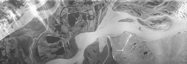
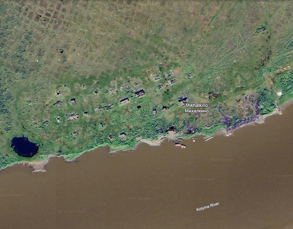 The village of Mikhalkino was located across the river from the airfield. It has long been abandoned, as seen in this contemporary Google Earth image which also reveals multiple sunken boats on the shore. (credit: Google Earth) |
A 1965 intelligence report indicated that the runway was first detected by CORONA satellite photography and not in earlier aerial photography, if there was any of that area. The runway probably first appeared in CORONA satellite photography in 1960 or 1961, although there is no indication that the United States detected the airfield during its construction. It is possible that any report mentioning the airfield from 1960 to 1963 has not been declassified; the first available report referring to it is from June 1963. That report indicated that there were no aircraft detected at Aspidnoye.
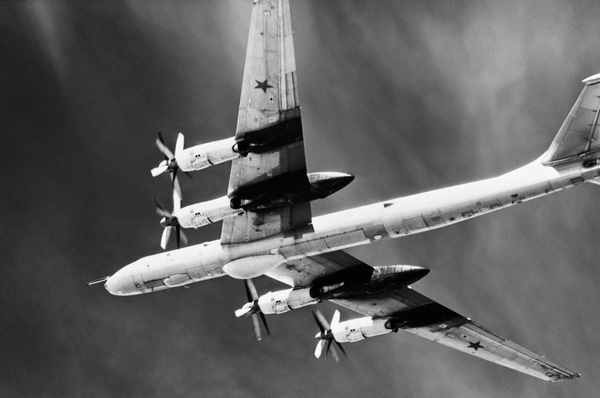 A Soviet Tu-95 Bear strategic bomber. The Bear first flew in the 1950s and was the primary Soviet long-range strategic bomber by the early 1960s. Aspidnoye airfield was built to handle large aircraft like the Bear. (credit: US Navy) |
Declassified imagery reports refer to Aspidnoye as both an airbase and an airfield, but it was actually little more than an unusually long 15,000-foot (4,600-meter) runway with a large overrun area at the end, and a large taxiway alongside. The length indicated that the runway was intended for the largest and heaviest aircraft, strategic bombers, and the large taxiway could have been used to park many aircraft. At the time, the Soviet Union’s main long-range strategic bomber was the Tu-95 Bear, which had first flown in 1952. The plane’s large size required large airfields.
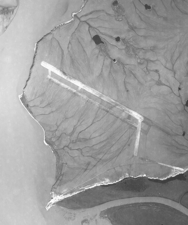 This image of the Aspidnoye airfield taken by a LANYARD satellite in July 1963 revealed that the runway was graded earth and not paved. No aircraft were detected. A partially-graded area running off from the extension off the end of the runway runs most of the way towards the river. Its purpose is unknown, but it appears unfinished. Were more extensive construction plans abandoned? (credit: Harry Stranger) |
In late July 1963, the only successful LANYARD reconnaissance satellite mission photographed Aspidnoye at higher resolution than previous CORONA missions, although no aircraft were spotted then either. What may have been a support facility near the river was too blurry and over-exposed to reveal much detail other than several buildings, located far from the runway. LANYARD’s better photography compared to earlier CORONA photos may have revealed that the runway was made of graded earth and not paved. Intelligence analysts determined the airfield was probably not usable during the summer due to mud and drainage across the surfaces (see “Lemons to bitter lemonade: from the Samos E-5 to the LANYARD reconnaissance satellite (part 2),” The Space Review, August 3, 2026.)
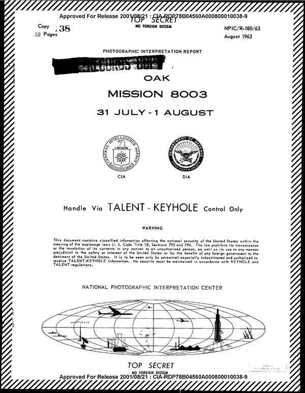 An imagery report produced from the only successful KH-6 LANYARD reconnaissance mission in summer 1963 indicated that the Aspidnoye airfield was probably not useable during the short summer months because it would have been too muddy. (credit: CIA) |
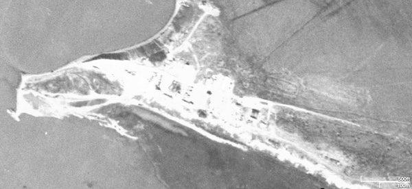 No major structures were located near the runway, but a support area was located a few kilometers away near the Kolyma River. This 1963 LANYARD photo did not provide enough detail to assess the structures, but later satellite photos did. A small object offshore is a boat that ran aground. (credit: Harry Stranger) |
Calling Aspidnoye a facility or an airbase was a stretch. Other than the long runway and a long taxiway, there were only about a dozen buildings nearby, at the end of a road and near the river, not near the runway. A few of them were larger, perhaps troop barracks. Facilities for maintaining aircraft would naturally be closer to the airfield, not at the end of a long road. No other obvious infrastructure is apparent: no control tower, no roads, port facility, hangars, barracks, maintenance buildings, snow plows, fuel trucks, or fuel depots.
Large Soviet military facilities like airbases received constant attention from American satellites, and intelligence analysts created regular reports on them, identifying all of their structures, even those as banal as sewer treatment facilities. For Aspidnoye, there was never any activity underway when it was photographed from above, and thus there was probably no intelligence report dedicated to it. American satellites flew over the area throughout the 1960s, and analysts noted that the airfield was covered in snow during the winter months, an indication that it was not operational.
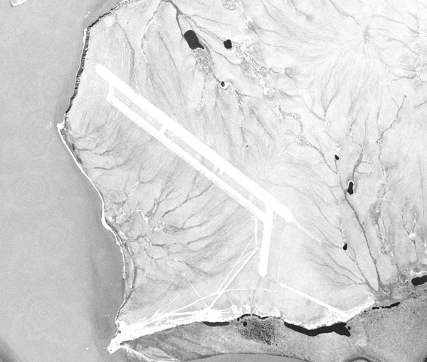 This July 1965 CORONA satellite photo was lower quality than the 1963 LANYARD photograph, but again no aircraft were at the airfield. The grounded boat visible in the 1963 photo has still not moved. (credit: Harry Stranger) |
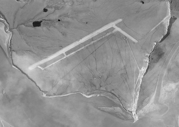 In August 1966 a GAMBIT reconnaissance satellite overflew Aspidnoye and took a better quality photo. No aircraft were detected, and no new construction has occurred at the runway. (credit: Harry Stranger) |
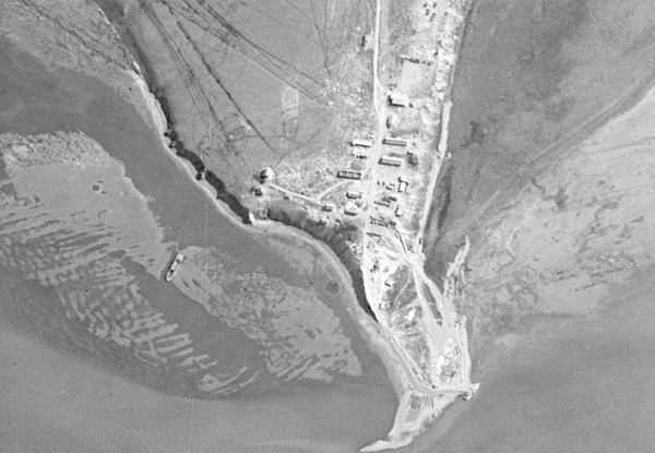 The GAMBIT satellite photographed the support area near the river. Several buildings are visible, including one with a missing roof. The long buildings were approximately 50 meters long and possibly barracks. The grounded boat is still visible. (credit: Harry Stranger) |
GAMBIT satellite photos taken in July 1965, August 1966, and May and June 1967 revealed no aircraft at the airfield and no obvious signs of activity. Although only a few declassified intelligence reports referring to Aspidnoye exist, they all indicate that no aircraft were detected at the airfield when satellites photographed it. A couple of photos on the internet show American-made twin-engine DC-3 transports in Soviet markings reportedly at Aspidnoye, but that aircraft did not require a long runway for operations.
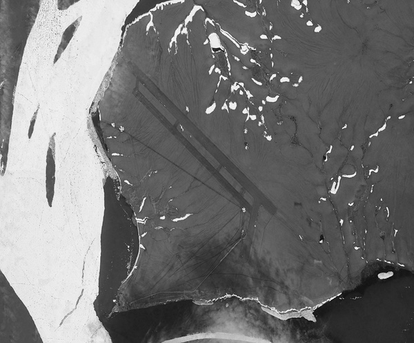 In May 1967 a GAMBIT satellite overflew the airfield. Some snow was still on the ground. No aircraft are visible, and the runway is crisscrossed with cracks. (credit: Harry Stranger) |
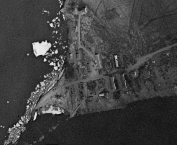 Ice is still present in the river near the support area in this May 1967 GAMBIT photo. The long building previously missing a roof in August 1966 now has one, indicating that the facility has not been abandoned. (credit: Harry Stranger) |
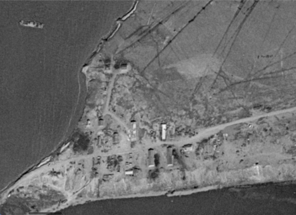 This June 1967 GAMBIT photo shows the support area near the river. What may be vehicles are near some of the buildings. The grounded boat first spotted in July 1963 has not moved. (credit: Harry Stranger) |
The last declassified intelligence report that mentions the airfield was from a spring 1973 overflight by the fifth HEXAGON reconnaissance satellite. That report indicated that the airfield was “not operational.” It had probably never been operational, raising the question of why the Soviet Union never fully developed the airfield. A 1980 HEXAGON Mapping Camera photographed the entire area and there was no indication that anything had changed.
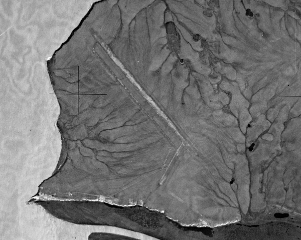 By 1973, the CIA had declared Aspidnoye as “non-operational.” This 1980 photo was taken by a HEXAGON Mapping Camera. It was much lower resolution than other photos, but still reveals no aircraft are present. (credit: Harry Stranger) |
The faint outlines of the runway are still visible today in satellite photos, as is a road leading from the runway to the remains of a few large structures and down to the river. If anybody was actually assigned there after its construction, they must have done something bad to deserve it, like made a drunken pass at a general’s daughter. It was bad enough to be sent to Siberia; it must have been worse to be sent to Aspidnoye.
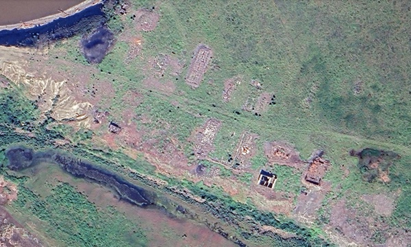 Today most of the buildings in the support area near the river have collapsed or burned to the ground, like so many Soviet Cold War-era military facilities. (credit: Google Earth) |
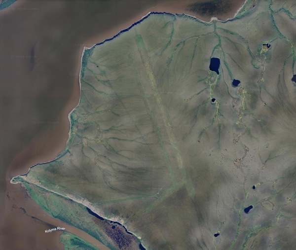 Aspidnoye is visible on Google Earth. It has long been abandoned and there is no sign of activity anywhere near the mysterious airfield in the middle of nowhere. (credit: Google Earth) |
Note: we are now moderating comments. There will be a delay in posting comments and no guarantee that all submitted comments will be posted.