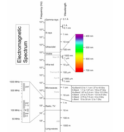
Dealing with Galaxy 15: Zombiesats and on-orbit servicing<< page 1: the big racetrack in the sky 3. Beeps and squeaks: Electromagnetic and radiofrequency interferenceThe orbital mechanics of the physical environment discussed above is only part of the picture to fully understanding the scope of the Galaxy 15 challenge. There is another side to the GEO environment that is invisible to our eyes and even optical telescopes. It is the electromagnetic (EM) environment, and it is here that Galaxy 15 poses the biggest short-term challenge. In addition to being the most physically congested region, the GEO belt is also a region in space that suffers from significant electromagnetic and more specifically radiofrequency (RF) inference. This is partly because, as discussed above, the satellites in GEO are all in relative close proximity to each other, as seen from the Earth. More importantly, though, many of the satellites in GEO broadcast on the same frequencies. To understand why this is, we need to examine the electromagnetic spectrum and talk about more physics. The electromagnetic spectrum is the range of all possible frequencies of electromagnetic radiation. Figure 3 shows the EM spectrum, which stretches from very low frequency waves (radio and TV) to very high frequency waves (gamma and X-rays).
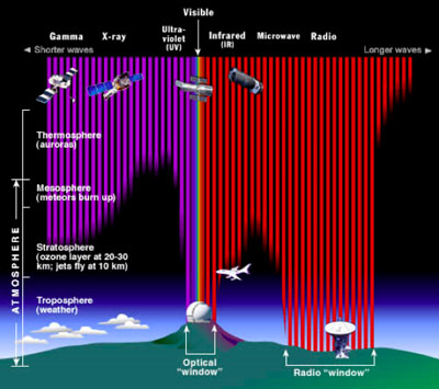
In theory, any of these wavelengths can be used to carry information. However, if you need to transmit from space to the ground there is a catch: the Earth’s atmosphere absorbs large portions of the EM spectrum, meaning that entire ranges of the spectrum are ill-suited for this function. Figure 4 shows the wavelengths that are absorbed by the Earth’s atmosphere and about how far the various types can reach. There are only two “windows” in the atmosphere that permit EM waves to travel without attenuation: the optical window and the radio window.
The optical window played a massive role in plant and animal evolution on planet Earth and is the reason why our eyes have evolved to perceive the “visible” portion of the spectrum that we do. And while optical frequencies are used extensively for communications through fiber optic links, those frequencies are ill suited for satellite communications applications. Transmitted through free space, incoherent optical frequencies disperse quickly. Coherent optical signals—lasers—can carry large amounts of information but can only carry it point-to-point and not over a large area. Additionally, the technology to create and utilize lasers for communication has only recently been developed. Optical wavelengths are also blocked by physical barriers such as walls and ceilings. Radio waves, on the other hand, are very useful for space-to-ground communications. They can be generated fairly easily and reliably using just electrical power, and can be used to broadcast a signal over either a very wide or very narrow area.
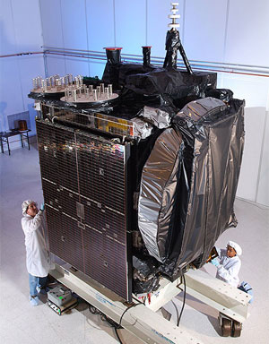
Calculating the bandwidth (or information carrying) potential for a given frequency is a complicated matter, but essentially the higher the frequency used for a communications channel, the more information a signal can carry and thus the higher bandwidth of that channel. Figure 3 also shows some of the frequency allocations, called bands, which are within the radio window. Most current communications satellites use what is called C-Band, between 2 and 4 Ghz. Recent advances in technology and engineering have allowed satellites to be built which use high frequencies such as Ku (12.5 to 18 Ghz) and most recently Ka (27 to 40 Ghz). However, given that commercial communications satellites are expensive investments, they are usually engineered to last several years or more. Thus, many of the current satellites in use, including Galaxy 15, operate in the C-Band. A communications satellite is essentially a giant relay. Transmissions are sent to it via an uplink channel and the satellite re-broadcasts these transmissions via one or more downlink channels. The geographic area on the Earth these downlinks can cover is called the footprint, and they can cover the entire portion of the planet under the satellite, a technique known as broad beaming, or just a very small region, known as spot beaming. Galaxy 15’s users have been shifted to other satellites, meaning that there is no longer anyone deliberately sending signals for it to re-broadcast and thus it is not actively transmitting. However, because all of its receive and transmit gear is still working, Galaxy 15 is essentially an open microphone which could accidently pickup and re-broadcast C-band signals it comes across as it drifts through the GEO belt. This is the primary concern as it drifts past other active C-Band satellites, the first of which is the aforementioned AMC 11. As it drifts past, Galaxy 15 could pickup and re-broadcast C-band emissions intended for AMC 11, potentially causing multi-path interference. 4. Is that a tow truck coming towards me? Recommended steps to deal with future situationsHaving discussed the physical and electromagnetic problems that Galaxy 15 is creating, we can now talk about what can be done to mitigate this problem or perhaps even prevent it from happening again. Unfortunately, the answer for right now is not much. First, it cannot be understated how important space situational awareness is to this situation. SSA provides the critical information about what is happening in Earth orbit and the possible negative impacts events might have. A satellite operator such as Intelsat has excellent information about the locations of their satellites, but no accurate information about the locations of other objects in orbit, including satellites operated by others and debris. The United States military operates global networks of ground and space-based radars and optical telescopes which are used to build catalogs of objects in orbit (see “The Numbers Game”, The Space Review, July 13, 2009, for more details). These catalogs are the best sources of information about space debris, but generally do not have as good information about actives satellites as those satellites’ owners do. This means that the key to establishing good SSA is data sharing between the states that operate sensor networks, and thus have the best data on locations of space debris, and the satellite operators, which have the best data on the locations their satellites. This positional data also needs to be combined with space weather forecasts, modeling, and warning. In this regard, the Iridium-Cosmos collision in February 2009 prompted the US to begin to offer SSA sharing services to nations and commercial operators through its Shared Space Situational Awareness program (formerly known as CFE). Intelsat and other members of the GEO satellite operator community have also come together to form the Space Data Association to share data among participating operators and potentially other entities. Both of these are significant developments toward solving some of the issues associated providing SSA and data sharing and should be applauded, but much more still needs to be done.
From all the known evidence, Intelsat should not be blamed for this incident. Unfortunately, satellites fail in the active GEO belt regularly—on average about one per year. In February 2010, another Intelsat satellite, IS-4, also failed in the active GEO belt at its operational slot of 72° E, although it was close to the end of its expected service life. On May 17, 2010, a Russian communications satellite, Express-AM1, apparently had an on-orbit failure of its attitude-control system in its operational slot at 40° E over Europe. At this time it is unknown if it can be moved to a disposal orbit. There can be a variety of reasons for these failures. The two most likely scenarios are a severe space weather event, for which manufacturing or operational solutions that mitigate the threat are not presently available, or an equipment failure on the satellite, perhaps the result of a problem with design or manufacturing. What is unusual in the case of Galaxy 15 is that the failure did not damage its communications payload. However, this situation could have happened to any of the satellite operators—it just happened to be Intelsat this time, and it is almost certain that similar failures will occur again with another spacecraft. Through its actions during this event, Intelsat is setting a new enhanced standard for how a satellite operator should respond when situations like this happen. Intelsat has been working feverishly not only to try and regain control or turn off the satellite, but also to notify their fellow satellite operators (and competitors) and work with them to try and find ways to mitigate the problem. Intelsat’s actions with regard to communication and cooperation in this situation should be considered the standard of care by all satellite operators for future situations of this nature. This is in stark contrast to what happened with another recent failure, that of DSP Flight 23 in the fall of 2008 (see “The ongoing saga of DSP Flight 23”, The Space Review, January 19, 2009, for more details). DSP-23 was a US military satellite which was placed into GEO in November 2007 as part of an existing constellation which provides global missile warning. The first reports of DSP-23’s failure came not from the US government but from amateur satellite observers who had noticed that it had stopped station-keeping in its assigned slot and had also stopped broadcasting as powerfully as before. DSP-23 was originally located over Europe and drifted towards the libration point at 75° E over India, going right through a cluster of three operational satellites operated by Eutelsat and then a cluster of six satellites operated by SES Astra. Sadly, it was the same amateur observers who provided SES Astra with the first warning that DSP-23 would drift through their constellation, and it was only after it broke in the media that the US government provided assistance to SES Astra. It is not just the United States that has acted with undue secrecy when it comes to its sensitive satellites adrift in the active GEO belt. There are numerous Russian military satellites that either failed or were intentionally left in the active GEO belt, along with many Russian rocket bodies. And while the United States has made significant strides recently in providing conjunction assessment assistance for all space actors, the Russian government still does not even provide basic catalog data on debris to the public. Although SSA, communication, and cooperation are critical to responsibly dealing with a “zombiesat” situation, they do not solve the problem. This leads one to consider the core problems of placing objects into space, particularly in the GEO orbit: What do we do when a spacecraft “breaks”? Satellite engineers put a lot of time and effort into designing systems that are redundant on multiple levels and can withstand the harsh space environment. However, satellites are complex machines and do fail, and when they do so in orbit, their operator can’t just pull over into a pit-stop to the side of the road and call for a tow to the nearest repair shop. That may soon be changing. Recently, there has been renewed interest in the concept of on-orbit servicing (OOS), the ability to refuel, move, or even fix satellites in orbit. In 2007, a student group from the International Space University produced a detailed report on the topic, outlining which missions have the most viability from a technical and economic standpoint and what the challenges are to making OOS a reality.
In March 2007, the Defense Advanced Research Projects Agency (DARPA) conducted an experimental mission in low Earth orbit to test some OOS technologies. Dubbed Orbital Express, it consisted of two spacecraft: the Autonomous Space Transport Robotic Operations (ASTRO) vehicle and a prototype next-generation serviceable satellite called NEXTSat. Over the course of three months, the two spacecraft conducted a series of operations, including docking and transfer of fuel and a battery change. Recently, MacDonald, Dettwiler and Associates (MDA), a major Canadian space contractor, announced that it saw increased evidence of a business case for OOS, especially in the GEO region, and that it is currently working on further developing the Orbital Express technology for GEO applications. Development of OOS technologies could potentially allow for several beneficial capabilities. The first would be placing an on-orbit “tow truck” in the GEO belt (or in low Earth orbit) that could be used to move malfunctioning satellites such as Galaxy 15 back to their assigned slots. If everything else is working except for their ability to maneuver, the tow truck or other system could attach an auxiliary maneuvering system to the satellite to repair and allow it to resume operation. An orbital tow truck could also be used to boost satellites out of the active GEO belt at the end of their service life. This tow truck function could also be expanded to include all the dead spacecraft, rocket bodies, and other large pieces of debris already littering GEO. Known as orbital debris removal (ODR), this process of actively removing objects is the only known way to clean out the legacy debris that exists in GEO and is a topic that has received a lot of attention lately. Currently, one of the biggest issues with this is accurately estimating the amount of fuel remaining onboard a satellite. This is very difficult to do, with potentially serious cost implications for the operator. If they err on the side of caution and dispose of the satellite early, it could mean forgoing months or years of revenue generated by the satellite. But if they wait too long, they might not have enough fuel to move the satellite out of the way. In either case, hiring an OOS satellite to perform the disposal maneuver for them could be very beneficial. At the 5th European Space Debris Conference in spring 2009, scientists and debris researchers concluded that simply reducing the amount of space debris we create is not going to solve the problem. There is enough existing debris that even with no new launches, debris-on-debris collisions will continue to create more debris. The researchers concluded that ODR is necessary to ensure the long term sustainability of Earth orbit, and that removing a few as five or ten of the most massive debris objects each year might be enough to stabilize the growth in debris population. These conclusions prompted DARPA and NASA to jointly sponsor the first International Conference on Orbital Debris Removal, held in December 2009.
There is a downside to developing these OOS capabilities: most of the technologies and capabilities that provide OOS could also be used to intentionally harm satellites and could be considered offensive counterspace capabilities. This is not a new concept: it dates back to almost the dawn of the Space Age with the original proposal by the American military for Project SAINT (short for SAtellite INTerceptor), a satellite consisting of a television camera and radar mounted in the nose of an Agena B upper stage. After being placed in orbit, SAINT would then maneuver close to an unfriendly target satellite, photograph and analyze it, and report back all the details to the US military. The US Air Force wanted to also give SAINT the ability to destroy or disable the target satellite, but such efforts were blocked by the Eisenhower and Kennedy administrations and the program was eventually canceled before it became reality. Recently the US military has funded a series of technology demonstration missions and experiments to develop different technology concepts similar to those found on the original non-destructive SAINT program. On April 11, 2005, the US Air Force launched XSS-11 (USA 165), which demonstrated the capability to rendezvous and inspect satellites in low Earth orbit using onboard cameras and LIDAR (Light Detection and Ranging). And on June 21, 2006, the launch of the MiTEx satellites provided this same capability in geosynchronous orbit (see “Mysterious microsatellites in GEO: is MiTEx a possible anti-satellite capability demonstration?”, The Space Review, July 31, 2006). Both XSS-11 and MiTEx were officially labeled technology demonstrators and limited to rendezvous and inspection of other pieces from their respective launches or other American satellites. However, the unofficial possibilities are obvious, and while XSS-11’s position was published in the public Space Track catalog, the MiTEx satellites (cataloged under their cover names of USA 187 and USA 188) have never had their position listed publicly by the U.S. military. NASA’s Demonstration for Autonomous Rendezvous Technology (DART) satellite was launched in 2005 and was intended to maneuver close to and conduct proximity operations around the defunct US Navy MUBLCOM satellite. A navigation error that occurred when DART and MUBLCOM were about 200 meters apart resulted in the two objects bumping at a speed of around 1.5 meters per second, slow enough that neither object generated debris nor was destroyed but fast enough to change the orbit of MUBLCOM significantly. Most recently, the United States launched the X-37B Orbital Test Vehicle 1 (OTV-1) on April 22, 2010. The X-37B is a miniature version of the space shuttle that is launched on top of a conventional space launch vehicle. It is intended to have the ability to stay on orbit for up to 270 days, with significant maneuverability within low Earth orbit and a rumored altitude ceiling of 800 kilometers. Although the OTV-1 was not equipped with a robotic arm, it could be launched with that capability in the future. Certainly, it could be equipped with sensors in its payload bay to examine other satellites. All that said, there is no evidence that the United States has developed any of these new programs with the goal of using them for offensive counterspace purposes. All of these programs are critical milestones in developing and advancing OOS technology and the lessons learned from them could be of great benefit in situations such as another Galaxy 15 or to eventually serve as orbital debris removal vehicles. However, the continued military funding of these programs coupled with the secrecy surrounding their activities in orbit and/or orbital position serves to garner objections from military space competitors such as Russia and China and promote paranoia and fear from global peace activists. This lack of transparency may cause other states to treat these programs as if they are space weapons. This will invariably lead them to pursue policies and programs that could destabilize the space security situation, which in the long run may be detrimental to the security of US space assets and long term sustainability of Earth orbit. Thus, it is within the interest of all space actors to continue the development of on-orbit servicing technologies that could be very beneficial to the diagnosis, recovery, or disposal of failed satellites and to remove existing space debris. But it is crucial that this development take place in as open and transparent a manner as possible to provide the necessary confidence that it is being done consistent with the peaceful uses of outer space, as laid down in the Outer Space Treaty. Essential to developing OOS capabilities and using them to reduce space debris and operational problems is the need to foster enhanced and integrated global space situational awareness capabilities in as many states as possible, potentially through participation in regional or international data sharing activities. The ability of states to have multiple, independent, and potentially indigenous sources of information about activities in orbit would be a major step towards alleviating many of the concerns regarding developing of OOS capabilities, and to de-conflict OOS capabilities and dual use technologies in general, including the need to service a particular satellite or remove a specific debris object. The satellite and space technology export controls that are currently in place in many countries will make it impossible to have full participation by all states in the technology development and operational testing of these capabilities. However, that does not mean that certain countries should be completely excluded from them. Transparency and confidence building can still be done through briefings on planned activities, openness in regard to the orbital location of potential dual-use spacecraft, and international participation in the selection of debris objects for removal and objects to be serviced. Some of the core elements of these policy recommendations do appear to have support within the US government. At a recent conference hosted by the Center for Strategic and International Studies, the Vice Chairman of the Joint Chiefs of Staff, General James Cartwright, warned that the US and other countries could no longer keep the vast numbers of orbiting satellites a secret, and that in some cases secrecy is hampering the competitiveness of the American space industry. He also called for some level of international rules and management for space traffic to increase safety and stability in space. Some of this thinking may be reflected in the forthcoming changes to US national space policy, which is expected to increase emphasis on international cooperation and establishment of norms of behavior in space. In the end, all states need to remember that outer space is the domain of no individual state, and the actions of any one actor in space can have consequences for the orbital environment and on the operations of all other space actors. There is a shared incentive to create stability and sustainability into the environment to ensure that all states can continue to have access to and use space for benefits here on Earth. Home |
|